Winnipeg Route 125

Last updated

Winnipeg city route 125.svg

Winnipeg Route 125
Jubilee Avenue
Route information
Maintained by City of Winnipeg
Length1.6 km [1] (1.0 mi)
Existed1966–present
Major junctions
West end Route 42 (Pembina Hwy)
East end Route 62 (Osborne St)
Highway system
Manitoba provincial highways
Winnipeg City Routes
Winnipeg city route 115.svg Route 115 Route 135 Winnipeg city route 135.svg

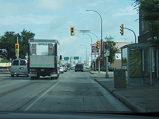
Route 125 (Jubilee Avenue) is a city route in Winnipeg, Manitoba, Canada. At only 1.6 kilometers in length, it is the shortest designated city route, running from an interchange with Route 42 (Pembina Highway) to Route 62 (Osborne Street).

Winnipeg Provincial capital city in Manitoba, Canada

Winnipeg is the capital and largest city of the province of Manitoba in Canada. Centred on the confluence of the Red and Assiniboine rivers, it is near the longitudinal centre of North America, approximately 110 kilometres (70 mi) north of the Canada–United States border.

Manitoba Province of Canada

Manitoba is a province at the longitudinal centre of Canada. It is often considered one of the three prairie provinces and is Canada's fifth-most populous province with its estimated 1.3 million people. Manitoba covers 649,950 square kilometres (250,900 sq mi) with a widely varied landscape, stretching from the northern oceanic coastline to the southern border with the United States. The province is bordered by the provinces of Ontario to the east and Saskatchewan to the west, the territories of Nunavut to the north, and Northwest Territories to the northwest, and the U.S. states of North Dakota and Minnesota to the south.

Canada Country in North America

Canada is a country in the northern part of North America. Its ten provinces and three territories extend from the Atlantic to the Pacific and northward into the Arctic Ocean, covering 9.98 million square kilometres, making it the world's second-largest country by total area. Canada's southern border with the United States, stretching some 8,891 kilometres (5,525 mi), is the world's longest bi-national land border. Its capital is Ottawa, and its three largest metropolitan areas are Toronto, Montreal, and Vancouver. As a whole, Canada is sparsely populated, the majority of its land area being dominated by forest and tundra. Consequently, its population is highly urbanized, with over 80 percent of its inhabitants concentrated in large and medium-sized cities, with 70% of citizens residing within 100 kilometres (62 mi) of the southern border. Canada's climate varies widely across its vast area, ranging from arctic weather in the north, to hot summers in the southern regions, with four distinct seasons.

Contents

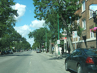
Jubilee Avenue is a collector road with two lanes in each direction, running through residential areas in Fort Garry and Fort Rouge. The speed limit is 50 km/h (30 mph) for the entire length of the route. The street is named in commemoration of Queen Victoria's Diamond Jubilee in 1897. [2]

Collector road low-to-moderate-capacity road which serves to move traffic from local streets to arterial roads

A collector road or distributor road is a low-to-moderate-capacity road which serves to move traffic from local streets to arterial roads. Unlike arterials, collector roads are designed to provide access to residential properties. Rarely, jurisdictions differentiate major and minor collector roads, the former being generally wider and busier.

Fort Garry, Winnipeg human settlement in Manitoba, Canada

Fort Garry is a district of the Canadian city of Winnipeg, Manitoba, located in the southwestern part of the city south of the district of Fort Rouge and east of the former town of Tuxedo. It was named for the historical fortification in Downtown Winnipeg known as Upper Fort Garry, although the nearest (northernmost) point of the district is actually 3.75 km from the site of the fort.

Fort Rouge, Winnipeg human settlement in Manitoba, Canada

Fort Rouge is a district of Winnipeg, Manitoba. Located in the south-central part of the city, it is bounded on the north by the Assiniboine River, on the east and south by the Red River, and on the west by Stafford Street and Pembina Highway. Fort Rouge is not a discrete census district, so its population cannot be easily obtained through census records; the 2006 combined population of Fort Rouge and the neighbouring district of River Heights was 56,505.

Major intersections

The entire route is in Winnipeg.

km [1] miDestinationsNotes
0.00.0Winnipeg city route 42.svg Pembina Highway ( Route 42 )Interchange
1.60.99Winnipeg city route 62.svg Osborne Street ( Route 62 )
1.000 mi = 1.609 km; 1.000 km = 0.621 mi

Notable Locations

Related Research Articles

Route 17, also known as Chief Peguis Trail, or CPT, is a major highway in Winnipeg, Manitoba, Canada. The highway connects Routes 52 and 20.

Route 20 is a major north-south arterial route in the city of Winnipeg, Manitoba, Canada. It is also part of Manitoba Highway 59, the only Provincial Trunk Highway that crosses through the city.

Route 23 is a city route in Winnipeg, Manitoba, connecting Route 180 and Route 52.

Route 96 is a city route in Winnipeg, Manitoba, Canada. The route commences at Portage Avenue and ends at Wilkes Avenue.

Route 145 is an arterial road in Winnipeg, Manitoba, Canada. It follows Wilkes Avenue and the Sterling Lyon Parkway, running east from an interchange at the Perimeter Highway to Waverley Street. Heading west from Winnipeg, it continues as Provincial Road 427 into the Rural Municipality of Headingley. Wilkes Avenue runs parallel to the main Canadian National Railway line.

Route 30 is a city route in Winnipeg, Manitoba. It runs from Highway 1/Route 135 to Route 37.

Route 47, locally known as Logan Avenue, is a city route in Winnipeg, Manitoba, Canada. It runs from Route 90 to Route 42. It is primarily a collector road through industrial and older residential areas of north-central Winnipeg. The speed limit is 50 km/h (30 mph).

Route 25 is a city route in the Canadian city of Winnipeg, Manitoba. It follows Inkster Boulevard from Route 90 to Route 180. West of Route 90, Inkster Boulevard becomes PTH 190 as it leaves Winnipeg and enters the Rural Municipality of Rosser. East of McPhillips, Inkster continues to Route 52, but this is not part of Route 25.

Winnipeg Route 70 city route in Winnipeg

Route 70 is a city route in Winnipeg, Manitoba, Canada. It runs from Route 57 to Route 42.

Winnipeg Route 85 city route in Winnipeg

Route 85, also known as Portage Avenue, is a major arterial route in the Canadian city of Winnipeg, Manitoba. It is one of the city's oldest and most important roads and is part of both the Trans-Canada and Yellowhead Highways.

Route 80, locally known as Waverley Street, is a city route in the southwest portion of Winnipeg, Manitoba, Canada. It runs from Kenaston Boulevard to Grant Avenue.

Alberta Highway 28A

Alberta Provincial Highway No. 28A, commonly referred to as Highway 28A, is an 18-kilometre (11 mi) highway in Alberta, Canada that connects Highway 15 in northeast Edmonton to Highway 28 near Gibbons. It is numbered 17 Street NE within Edmonton and forms an alternate route to Highway 28 into the city from the north. As the southernmost component of the Edmonton–Fort McMurray corridor, the highway is designated as a core route of Canada's National Highway System for its entire length.

Winnipeg Route 95 city route in Winnipeg

Route 95 is a city route located in Winnipeg, Manitoba. It runs in the southwest part of the city from Route 105 east to Route 42. It is named Roblin Boulevard west of Assiniboine Park, where it then becomes Corydon Avenue for the remainder of its route. It meets Route 42 near the Confusion Corner intersection.

Provincial Road 204 is a provincial road in the Canadian province of Manitoba. PR 204 stretches from the Province's capital, Winnipeg to Selkirk, running under the name Henderson Highway between Winnipeg and PR 202. It has a short concurrency with PTH 44 in Lockport. PR 204 is part of the La Vérendrye Trail between Winnipeg and PR 212 in East Selkirk.

Route 90 is a major north-south arterial route in Winnipeg, Manitoba, Canada. It begins at the South Perimeter Highway and ends at the city's northwest limit, where it continues north as PTH 7. Route 90 is designated as the city's airport route, as it passes by Winnipeg James Armstrong Richardson International Airport.

Route 42 is a major arterial road located in Winnipeg, Manitoba. It connects the suburbs of North Kildonan, East Kildonan, Fort Rouge, Fort Garry, and St. Norbert with the city's downtown core. In the north, it is a continuation of Manitoba Provincial Road 204; in the south, it is a continuation of PTH 75, also known as the Lord Selkirk Highway.

Route 52 is a major north-south arterial route in Winnipeg, Manitoba, Canada. It comprises all of Main Street, Queen Elizabeth Way, and St. Mary's Road.

Victoria Trail

Victoria Trail is an arterial road under construction in northeast Edmonton, Alberta, Canada. It begins at the same Yellowhead Trail interchange as 118 Avenue, travels north through a number of neighbourhoods, and currently ends at 153 Avenue. The City of Edmonton plans to expand the residential area north, this new neighbourhood will be called Gorman, and a new LRT station will be opened in the future, also called Gorman. The current construction schedule has the Anthony Henday Drive constructed after the LRT tracks and Victoria Trail extended north.

Fort Road, Edmonton

Fort Road was a major route in connecting Edmonton and Fort Saskatchewan, Alberta, Canada. It was formed on the west side of the CN Rail tracks that formerly connected the two cities, and crossed the North Saskatchewan River just south of the current Highway 15 bridge. As the city of Edmonton expanded its grid street system, and realigned the highway to Manning Drive, portions of Fort Road ceased to exist. At the intersection of Fort Road and 66th street stands the Transit Hotel, which opened in 1908.

Yellowhead Trail

Yellowhead Trail is a 24.6-kilometre (15.3 mi) expressway segment of the Yellowhead Highway in northern Edmonton, Alberta, Canada. It carries a significant amount of truck traffic to and from the industrial areas of north Edmonton and serves as a key commuter route for the bedroom communities of Stony Plain, Spruce Grove, and Sherwood Park, carrying nearly 80,000 vehicles per weekday in 2015. A suburban bypass of the route was completed when the northeast leg of Anthony Henday Drive (Highway 216) opened in late 2016, providing an alternate route through north Edmonton.

References

  1. 1 2 Google (January 22, 2019). "Route 125 in Winnipeg" (Map). Google Maps . Google. Retrieved January 22, 2019.
  2. History in Winnipeg Streets

Route map:

KML file (edithelp)
    KML is from Wikidata