Wivenhoe Gravel Pit

Last updated
Wivenhoe Gravel Pit
Site of Special Scientific Interest
Wivenhoe Gravel Pit 3.JPG
Area of Search Essex
Grid reference TM050236
Interest Geological
Area 2.1 hectares
Notification 1992
Location map Magic Map

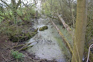
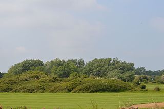
Wivenhoe Gravel Pit is a 2.1 hectare geological Site of Special Scientific Interest north of Wivenhoe in Essex. [1] [2] It is a Geological Conservation Review site. [3]

Site of Special Scientific Interest Conservation designation denoting a protected area in the United Kingdom

A Site of Special Scientific Interest (SSSI) in Great Britain or an Area of Special Scientific Interest (ASSI) in the Isle of Man and Northern Ireland is a conservation designation denoting a protected area in the United Kingdom and Isle of Man. SSSI/ASSIs are the basic building block of site-based nature conservation legislation and most other legal nature/geological conservation designations in the United Kingdom are based upon them, including national nature reserves, Ramsar sites, Special Protection Areas, and Special Areas of Conservation. The acronym "SSSI" is often pronounced "triple-S I".

Wivenhoe town in north eastern Essex, England, United Kingdom

Wivenhoe is a town and civil parish in north eastern Essex, England, approximately 3 miles (4.8 km) south east of Colchester. Historically Wivenhoe village, on the banks of the River Colne, and Wivenhoe Cross, on the higher ground to the north, were two separate settlements but with considerable development in the 19th century the two have merged.

Essex County of England

Essex is a county in the south-east of England, north-east of London. One of the home counties, it borders Suffolk and Cambridgeshire to the north, Hertfordshire to the west, Kent across the estuary of the River Thames to the south, and London to the south-west. The county town is Chelmsford, the only city in the county. For government statistical purposes Essex is placed in the East of England region.

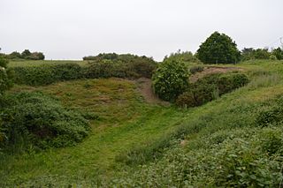
The site is the type locality for the Wivenhoe Gravel, which was laid down by the River Thames before it was diverted south to its present course by the Anglian glaciation around 450,000 years ago. The gravel was laid down during two cold stages with an intervening interglacial, but the fossils in from this warmer period are not distinctive enough to identify which interglacial they come from. The site is important for establishing the previous course of the Thames. Two worked flints may be evidence of occupation by Homo heidelbergensis around half a million years ago. [4]

River Thames river in southern England

The River Thames, known alternatively in parts as the Isis, is a river that flows through southern England including London. At 215 miles (346 km), it is the longest river entirely in England and the second longest in the United Kingdom, after the River Severn.

Interglacial interval of time within an ice age that is marked by warmer temperatures

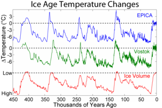
An interglacial period is a geological interval of warmer global average temperature lasting thousands of years that separates consecutive glacial periods within an ice age. The current Holocene interglacial began at the end of the Pleistocene, about 11,700 years ago.

<i>Homo heidelbergensis</i> Extinct species of the genus Homo

Homo heidelbergensis is an extinct species or subspecies of archaic humans in the genus Homo, which radiated in the Middle Pleistocene from about 700,000 to 300,000 years ago, known from fossils found in Southern Africa, East Africa and Europe. African H. heidelbergensis has several subspecies. The subspecies are Homo heidelbergensis heidelbergensis, Homo heidelbergensis daliensis, Homo rhodesiensis, and Homo heidelbergensis steinheimensi. The derivation of Homo sapiens from Homo rhodesiensis has often been proposed, but is obscured by a fossil gap from 400–260 kya. The species was originally named Homo heidelbergensis due to the skeleton's first discovery near Heidelberg, Germany.

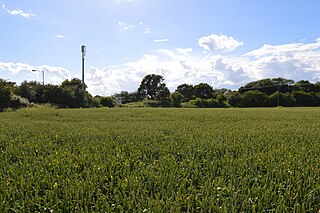
The pit, which is now water filled, is in a field off Brightlingsea Road opposite Broad Lanes.

Related Research Articles

Colne Estuary biological and geological Site of Special Scientific Interest near Brightlingsea in Essex

Colne Estuary is a 2915 hectare biological and geological Site of Special Scientific Interest near Brightlingsea in Essex. It is also a Nature Conservation Review site, a National Nature Reserve, a Ramsar wetland site of international importance, a Special Protection Area, a Special Area of Conservation, and a Geological Conservation Review site. Three areas in the site are managed by the Essex Wildlife Trust, Colne Point, Fingringhoe Wick and Howlands Marsh.

Swanscombe Heritage Park

Swanscombe Skull Site or Swanscombe Heritage Park is a 3.9 hectares geological Site of Special Scientific Interest in Swanscombe in north-west Kent. It contains two Geological Conservation Review sites, and a National Nature Reserve. The park lies in a former gravel quarry, Barnfield Pit.

Hornchurch Cutting

Hornchurch Cutting is an 0.8-hectare geological Site of Special Scientific Interest in Hornchurch in the London Borough of Havering. It is also a Geological Conservation Review site.

Wansunt Pit

Wansunt Pit is a 1.9 hectare geological Site of Special Scientific Interest in Dartford Heath between Crayford in the London Borough of Bexley and Dartford in Kent. It is also a Geological Conservation Review site. It is important geologically because it exposes the Dartford Heath Gravel, and the relationship of this exposure to the Swanscombe sequence and the Thames Terraces is a controversial issue in Thames Pleistocene studies. The site is part of Braeburn Park, a nature reserve managed by the London Wildlife Trust.

Downfield Pit

Downfield Pit is a 3.6 hectare geological Site of Special Scientific Interest near Ware in Hertfordshire. It is in the Geological Conservation Review in the Thames Pleistocene section, and the local planning authority is East Hertfordshire District Council.

Hillcollins Pit

Hillcollins Pit or Furneux Pelham Gravel Pit is a 0.2 hectare geological Site of Special Scientific Interest near Furneux Pelham in Hertfordshire. The local planning authority is East Hertfordshire District Council. it was identified as a site of national importance in the Geological Conservation Review in 1988.

Little Heath Pit

Little Heath Pit is a 0.3 hectare geological Site of Special Scientific Interest near Potten End in Hertfordshire. It is part of the Ashridge Estate, owned by the National Trust, and the local planning authority is Dacorum Borough Council. It is listed in the Geological Conservation Review.

Fern House Gravel Pit

Fern House Gravel Pit is a 1.3 hectare geological Site of Special Scientific Interest in Fern, near Bourne End in Buckinghamshire. It is also a Geological Conservation Review site.

Halls Quarry

Hall's Quarry is a 0.8 hectare geological Site of Special Scientific Interest north-west of Ugley Green in Essex. It is a Geological Conservation Review site.

Purfleet Chalk Pits

Purfleet Chalk Pits is a 10.7 hectare geological Site of Special Scientific Interest in Purfleet in Essex. It is a Geological Conservation Review site.

Ardleigh Gravel Pit

Ardleigh Gravel Pit is a 1.2 hectare geological Site of Special Scientific Interest south of Ardleigh in Essex. It is a Geological Conservation Review site.

Clacton Cliffs and Foreshore

Clacton Cliffs and Foreshore is a 26.1 hectare geological Site of Special Scientific Interest in Clacton-on-Sea in Essex. It is a Geological Conservation Review site.

Holland-on-Sea Cliff

Holland-on-Sea Cliff is a 0.1 hectare geological Site of Special Scientific Interest in Holland-on-Sea, north-west of Clacton-on-Sea in Essex. It is a Geological Conservation Review site.

St Osyth Pit

St Osyth Pit is a 0.1 hectare geological Site of Special Scientific Interest north of St Osyth in Essex. It is a Geological Conservation Review site.

Little Oakley Channel Deposit

Little Oakley Channel Deposit is a 3 hectare geological Site of Special Scientific Interest in Little Oakley in Essex. It is a Geological Conservation Review site.

Marks Tey Brickpit

Marks Tey Brickpit is a 29.5 hectare geological Site of Special Scientific Interest in Marks Tey in Essex. It is a Geological Conservation Review site.

Lofts Farm Pit

Lofts Farm Pit is a 4.5 hectare geological Site of Special Scientific Interest in Heybridge, a suburb of Maldon in Essex. It is a Geological Conservation Review site.

Goldsands Road Pit

Goldsands Road Pit is a 1.3 hectare geological Site of Special Scientific Interest in Southminster in Essex. It is a Geological Conservation Review site.

Newney Green Pit

Newney Green Pit is a 0.07 hectare geological Site of Special Scientific Interest west of Writtle in Essex. It is a Geological Conservation Review site.

References

  1. "Wivenhoe Gravel Pit citation" (PDF). Sites of Special Scientific Interest. Natural England. Retrieved 8 May 2016.
  2. "Map of Wivenhoe Gravel Pit". Sites of Special Scientific Interest. Natural England. Retrieved 8 May 2016.
  3. "Wivenhoe Gravel Pit (Quaternary of the Thames)". Joint Nature Conservation Committee. Retrieved 8 May 2016.
  4. "Wivenhoe Gravel Pit SSSI, WIVENHOE, Tendring District, TM050235, Site of Special Scientific Interest". The Essex Field Club. Retrieved 8 May 2016.

Coordinates: 51°52′19″N0°58′37″E / 51.872°N 0.977°E / 51.872; 0.977

Geographic coordinate system Coordinate system

A geographic coordinate system is a coordinate system that enables every location on Earth to be specified by a set of numbers, letters or symbols. The coordinates are often chosen such that one of the numbers represents a vertical position and two or three of the numbers represent a horizontal position; alternatively, a geographic position may be expressed in a combined three-dimensional Cartesian vector. A common choice of coordinates is latitude, longitude and elevation. To specify a location on a plane requires a map projection.