Lee County is located in Southwest Florida on the Gulf Coast. As of the 2020 census, the population was 750,822. The county seat is Fort Myers, and the largest city is Cape Coral with an estimated 2018 population of 189,343. Lee County comprises the Cape Coral–Fort Myers, FL Metropolitan Statistical Area.

Patrick County is a county located on the central southern border of the Commonwealth of Virginia. As of the 2020 census, the population was 17,608. Its county seat is Stuart. It is located within both the rolling hills and valleys of the Piedmont Region and the more mountainous Southwest Virginia.

Buena Vista is an independent city located in the Blue Ridge Mountains region of Virginia in the United States. As of the 2020 census, the population was 6,641. The Bureau of Economic Analysis combines the independent cities of Buena Vista and Lexington, along with surrounding Rockbridge County, for statistical purposes.

Clarendon is a city in, and the county seat of, Monroe County, Arkansas, United States. Located in the Arkansas Delta, the city's position on the White River at the mouth of the Cache River has defined the community since first incorporating in 1859. Although the river has brought devastation and disaster to the city occasionally throughout history, it has also provided economic opportunities, transportation, recreation and tourism to the city.

Louisa is a home rule-class city located at the merger of the Levisa and Tug Forks into the Big Sandy River. It is located in Lawrence County, Kentucky, in the United States, and is the seat of its county. The population was 2,467 at the 2010 census and an estimated 2,375 in 2018.

Copperhill is a city in Polk County, Tennessee, United States. The population was 354 at the 2010 census. It is included in the Cleveland Metropolitan Statistical Area.

Buchanan is a town in Botetourt County, Virginia, United States. The population was 1,196 at the 2020 census. It is part of the Roanoke Metropolitan Statistical Area. It was the western terminus of the James River and Kanawha Canal when construction on the canal ended.

Purcellville is a town in Loudoun County, Virginia. The population was 8,929 according to the 2020 Census. Purcellville is the major population center for Western Loudoun and the Loudoun Valley. Many of the older structures remaining in Purcellville reflect the Victorian architecture popular during the early-20th century.

Broadway is a town in Rockingham County, Virginia, United States. The population was 3,691 at the 2010 census. It is included in the Harrisonburg Metropolitan Statistical Area.

Bluemont is an unincorporated village in Loudoun County, Virginia located at the eastern base of Snickers Gap in the Blue Ridge Mountains. The village's center is located along Snickersville Turnpike, 4 miles (6.4 km) west of the incorporated town of Round Hill. The village borders Virginia's fox hunting country and is within 1 mile (1.6 km) of the Appalachian Trail and the Bears Den and Raven Rocks formations in the Blue Ridge.
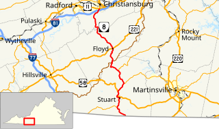
State Route 8 is a primary state highway in the U.S. state of Virginia. The state highway runs 55.88 miles (89.93 km) from the North Carolina state line near Palmetto, where the highway continues south as North Carolina Highway 8, north to U.S. Route 11 in Christiansburg. SR 8 is part of a 151-mile (243 km) two-state highway 8 system and is the main north–south highway of Patrick County, Floyd County, and southern Montgomery County, connecting their respective county seats of Stuart, Floyd, and Christiansburg with each other and with the Blue Ridge Parkway. The state highway also links the New River Valley region of Virginia with Southside Virginia via US 58 and the Piedmont Triad of North Carolina via NC 8.

State Route 57 is a primary state highway in the U.S. state of Virginia. The state highway runs 88.70 miles (142.75 km) from SR 8 near Woolwine east to SR 360 near Halifax. SR 57 connects the independent city of Martinsville with Chatham and Halifax, the county seats of Pittsylvania and Halifax counties, respectively. The state highway also connects the city to Fairy Stone State Park.

Syria is an unincorporated village in Madison County, Virginia, United States. It lies along the Old Blue Ridge Turnpike, adjoining the southeast border of the Shenandoah National Park. Its ZIP Code is 22743.
Mouth of Wilson is an unincorporated community, in Grayson County in the U.S. state of Virginia, just north of the North Carolina state line. The community lies in the Blue Ridge Highlands section of the Blue Ridge Mountains which are part of what is considered the 'Middle Appalachian Mountains' on the western banks of the New River, where the Big Wilson Creek empties its waters. The main road through the area is U.S. Route 58; other major roads include Virginia Route 16 and Virginia Route 93.

The Bob White Covered Bridge, also known as the Lower Covered Bridge or Woolwine Covered Bridge, was a county-owned wooden covered bridge that spanned the Smith River in Patrick County, Virginia, United States. It was located on the old portion of Bob White Road off State Route 8 southeast of the community of Woolwine, about 13 miles north of Stuart. Coordinates were 36°46′44.82″N80°14′51.26″W.

The Jack's Creek Covered Bridge, also known as the Upper Covered Bridge, is a county-owned wooden covered bridge that spans the Smith River in Patrick County, Virginia, United States. It is located on Jack's Creek Road (SR 615) off State Route 8 just south of the community of Woolwine, about 11 miles (18 km) north of Stuart.
Ivy is a census-designated place (CDP) in Albemarle County, Virginia, United States. The population as of the 2010 Census was 905. It is a small unincorporated community located on U.S. Route 250, just west of Charlottesville.

The natural environment of Virginia encompasses the physical geography and biology of the U.S. state of Virginia. Virginia has a total area of 42,774.2 square miles (110,784.67 km2), including 3,180.13 square miles (8,236.5 km2) of water, making it the 35th-largest state by area. Forests cover 65% of the state, wetlands and water cover 6% of the land in the state, while 5% of the state is a mixture of commercial, residential, and transitional.

Dante is a census-designated place in Russell and Dickenson counties, Virginia, in the United States. The population as of the 2010 Census was 649.

The Capon Lake Whipple Truss Bridge, formerly known as South Branch Bridge or Romney Bridge, is a historic Whipple truss bridge in Capon Lake, West Virginia. It is located off Carpers Pike and crosses the Cacapon River. The bridge formerly carried Capon Springs Road over the river, connecting Capon Springs and Capon Lake.


