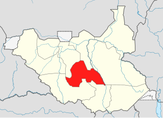
Lakes State is a state in South Sudan. It has an area of 43,595.08 km2. Rumbek is the capital of the state. Lakes is in the Bahr el Ghazal region of South Sudan, in addition to Northern Bahr el Ghazal, Western Bahr el Ghazal, and Warrap states. Bahr el Ghazal itself was a former province which was split from the Anglo-Egyptian mudiriyat, or province of Equatoria in 1948. The eastern border was the White Nile with Jonglei State on the opposite bank. To the northeast lied the Unity State. Other borders included Warrap State towards the northwest, Western Equatoria to the south and west, and Central Equatoria to the south.
The Province of the Episcopal Church of South Sudan, formerly known as the Episcopal Church of Sudan, is a province of the Anglican Communion located in South Sudan. The province consists of eight Internal Provinces and 61 dioceses. The current archbishop and primate is Justin Badi Arama. It received the current naming after the inception of the Province of the Episcopal Church of Sudan, on 30 July 2017.

The States of South Sudan were created out of the three historic former provinces of Bahr el Ghazal (northwest), Equatoria (southern), and Greater Upper Nile (northeast). The states are further divided into 79 counties.

South Sudan, officially the Republic of South Sudan, is a landlocked country in eastern Central Africa. It is bordered by Ethiopia, Sudan, the Central African Republic, the Democratic Republic of the Congo, Uganda, and Kenya, and includes the vast swamp region of the Sudd, formed by the White Nile and known locally as the Bahr al Jabal, meaning "Mountain Sea". The population was 11,088,796 in 2023, and Juba is the capital and largest city. South Sudan gained independence from Sudan on 9 July 2011, making it the most recent sovereign state or country with widespread recognition as of 2024.
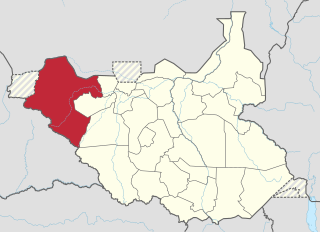
The Lol State was a state of South Sudan with the capital in Raga, that existed between 2 October 2015 and 22 February 2020. It was located in the Bahr el Ghazal region, which is in the northwest section of the country. Lol state bordered Haut-Mbomou and Haute-Kotto in the Central African Republic to the west, South Darfur and East Darfur in Sudan to the north, the disputed region of Kafia Kingi to the northwest, Aweil East State to the northeast, Aweil State to the east, Gbudwe State to the south, and Wau State to the southeast. The state was created alongside 27 other states after a decree issuing the creation of 28 states took place. It was dissolved at the conclusion of the South Sudanese Civil War.

Eastern Lakes State was a state in South Sudan that existed between 2 October 2015 and 22 February 2020. It was located in the Bahr el Ghazal region and it bordered Southern Liech to the north, Western States to the west, Amadi to the southwest, Terekeka to the southeast, and Jonglei to the east.
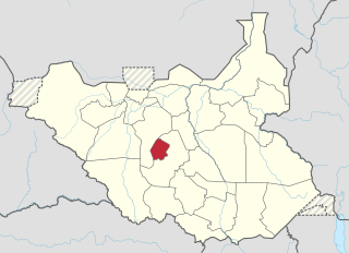
Gok was a state in South Sudan that existed between 2 October 2015 and 22 February 2020. It was located in the Bahr el Ghazal region, and was formerly part of the Lakes State. Gok State bordered Tonj to the west and Western Lakes to the east. The state had a population of 117,755 in 2008 and an estimated population of 174,460 in 2014.

Western Lakes was a state in South Sudan that existed between 2 October 2015 and 22 February 2020. It was located in the Bahr el Ghazal region and was part of the former state of Lakes State. It bordered Amadi State, Eastern Lakes State, Gbudwe State, Gok, Maridi State, Southern Liech State, and Tonj State.

Amadi State was a state in South Sudan that existed between 2 October 2015 and 22 February 2020. Amadi state formed from Western Equatoria state on 2 October 2015, following a decree that established the state along with 27 other states. It was located in the Equatoria region. Amadi State bordered Eastern Lakes State, Jubek State, Maridi State, Terekeka State, Western Lakes State, Yei River State.

Gbudwe State was a state of South Sudan that existed between 2 October 2015 and 22 February 2020. It was created from Western Equatoria state. Tambura State was split from Gbudwe State on January 14, 2017. Gbudwe State was located in the Equatoria region. Gbudwe bordered the states of Lol, Maridi, Tambura, and Western Lakes, and also the province of Haut-Uélé in the Democratic Republic of the Congo and Haut-Mbomou in the Central African Republic. The state had a population of 364,272 in 2008.

Maridi State was a state in South Sudan that existed between 2 October 2015 and 22 February 2020. It was formed on 2 October 2015 from Western Equatoria state. It was located in the Equatoria region. Maridi State bordered the states of Amadi State, Gbudwe State, Western Lakes State, and Yei River State.

Terekeka State was a state in South Sudan that existed between 2 October 2015 and 22 February 2020. It was located in the Equatoria region and it bordered Amadi, Eastern Lakes, Imatong, Jonglei, and Jubek. It has an estimated population of 176,030 in 2014, and the capital and largest city of the state is Terekeka, South Sudan.

The Ruweng Administrative Area is an administrative area in South Sudan. The area was known as Ruweng State between 2 October 2015 and 22 February 2020 when it was a state of South Sudan.

Akobo was a state in South Sudan that existed between 14 January 2017 and 22 February 2020.
Rumbek North County is an administrative area (county) located in Lakes State, South Sudan. In August 2016, the former Rumbek North County had split to create Aloor County and Malueth County.
Rumbek East County is an administrative area (county) located in Lakes State, South Sudan. In August 2016, the former Rumbek East County had split to create Eastern Bhar Naam County and Western Bhar Naam County. Headquarter of Rumbek East is located at Thon-Aduel
Rumbek Center County is an administrative area (county) located in Lakes State, South Sudan. In August 2016, the former Rumbek Center County had split to create Amongping County, Malek County and Rumbek County.
Maridi County is an administrative area in Western Equatoria, South Sudan. It borders Mvolo County to the north-east, Mundri West County to the east and Ibba County to the west. It also borders Lakes State to the north-west, Central Equatoria State to the south-east and the Democratic Republic of Congo to the south-west. The major ethnic groups in Maridi County are Baka, Mundu, Avukaya, Zande, Moro Kodo, and Wetu.
This article lists events from the year 2019 in South Sudan

Nzara County is a county in Western Equatoria State, South Sudan. And was part of Yambio county before South Sudan's independence.