
Cottage Grove is a city in Lane County, Oregon, United States. The population was 9,686 at the 2010 census. Cottage Grove is the third largest city in Lane County. The city is located on Interstate 5, Oregon Route 99, and the main Willamette Valley line of the CORP railroad.

The Mohawk River is the largest tributary of the McKenzie River, approximately 30 miles (48 km) long, in west central Oregon in the United States. It drains part of the foothills of the Cascade Range on the southeast end of the Willamette Valley northeast of Springfield.

The John Day River is a tributary of the Columbia River, approximately 6 miles (10 km) long, in northwestern Oregon in the United States. The river rises in the Northern Oregon Coast Range in Clatsop County at 46.138889°N 123.704722°W.

Goshen is an unincorporated community in Lane County, Oregon, United States. It is located at the junction of Oregon Route 58, Oregon Route 99, and Interstate 5.

Marcola is an unincorporated community in Lane County, Oregon, United States, northeast of Springfield on the Mohawk River.

Jasper is an unincorporated community in Lane County, Oregon, United States. It is southeast of Springfield on Oregon Route 222, at the confluence of Hills Creek and the Middle Fork Willamette River.

Walden is an unincorporated community in Lane County, Oregon, United States. It is about 3 miles (5 km) southeast of Cottage Grove, near the confluence of the Row River and Mosby Creek.

Wendling is an unincorporated community in Lane County, Oregon, United States, located northeast of Marcola. Wendling's post office operated from 1899 to 1952. It was named for George X. Wendling, a local lumberman.

Disston is an unincorporated community in Lane County, Oregon, United States, southeast of Cottage Grove where Brice Creek and Layng Creek join to form the Row River. It is about a mile west of the Umpqua National Forest. Its post office opened in 1906 and ran until 1974. Cranston Jones—the first postmaster—was also one of the founders of the first sawmill in Disston and the name of the town came from the famous Disston saws.

Mohawk is an unincorporated community in Lane County, Oregon, United States, on the Mohawk River, about seven miles upstream from Springfield.
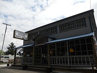
Cushman is an unincorporated community in Lane County, Oregon, United States. It is located on the north bank of the Siuslaw River on Oregon Route 126, between Tiernan and Florence.

Dolph is an unincorporated community in Tillamook County, Oregon, United States, near the Yamhill County line. It lies at the junction of Oregon Route 22 and Oregon Route 130 between Grande Ronde and Hebo, on the Little Nestucca River. It is within the Siuslaw National Forest in the Northern Oregon Coast Range.
Linslaw is an unincorporated community in Lane County, Oregon, United States. It is located about eight miles west of Walton on Oregon Route 126 next to the Siuslaw River.
Tiernan is an unincorporated community in Lane County, Oregon, United States. It is about five miles west of Mapleton on Oregon Route 126 near the Siuslaw River and within the Siuslaw National Forest.
Bridge is an unincorporated community in Coos County, Oregon, United States. It is about 9 miles (14 km) east of Myrtle Point on Oregon Route 42 near the Middle Fork Coquille River.
Suver is an unincorporated community in Polk County, Oregon, United States. It is located about 10 miles north of Corvallis and about 8 miles south of Monmouth, 1 mile east of Oregon Route 99W.

Mosby Creek is a 21-mile (34 km) tributary of the Row River in Lane County, in the U.S. state of Oregon. It begins at the confluence of the east and west forks of the creek near the Calapooia Divide and the border with Douglas County. From its source it flows generally north-northwest to meet the river slightly east of Cottage Grove and about 4 miles (6 km) from the larger stream's confluence with the Coast Fork Willamette River.

Tenmile Creek is a stream in Lane County, in the U.S. state of Oregon. It flows west from the Siuslaw National Forest in the Oregon Coast Range into the Pacific Ocean at Stonefield Beach State Recreation Site, about 6 miles (10 km) south of Yachats.
Ritner Creek is a tributary of the Luckiamute River in Polk County in the U.S. state of Oregon. The creek begins near Bald Mountain in the Central Oregon Coast Range and flows generally southeast to meet the Luckiamute southwest of Pedee and north of Kings Valley. The confluence is 31 miles (50 km) upstream of the Luckiamute's mouth on the Willamette River. Named tributaries of Ritner Creek from source to mouth are Sheythe, Love, Clayton, and Kinsey creeks.

Lost Creek is a tributary of the Middle Fork Willamette River in the U.S. state of Oregon. It begins in the Cascade Range foothills between Dorena Lake and Lookout Point Lake and flows generally north to meet the river downstream of Lowell. Along the way, it passes by the rural community of Dexter, then under Oregon Route 58, and through part of Elijah Bristow State Park. Named tributaries of Lost Creek from source to mouth are Guiley, Gossage, Carr, Middle, Anthony, and Wagner creeks.


