History
Prior to the late 1990s Yenga was a small fishing village. However, after occupation by the Revolutionary United Front (RUF), alluvial diamonds were discovered in the Makona River. [6] Mining [3] and agriculture [7] have replaced fishing as the major economic activity.
In 2001, during Sierra Leone’s civil war, the Republic of Guinea sent troops into Yenga [3] to help the army of Sierra Leone suppress the rebel RUF. After the rebels were quashed, the Guinean soldiers remained in Yenga. Prior to the civil war Yenga was administered by the Kailahun District of Sierra Leone. [8] In 2002 Sierra Leone and Guinea signed an agreement than Yenga would be returned to Sierra Leone, as soon as Guinea's border could be secured. [3] In 2005 Sierra Leone and Guinea signed an agreement that Yenga belonged to Sierra Leone. [9] The dispute was officially "resolved" in 2019 when President Ahmad Tejan Kabbah announced that "Conakry has now affirmed that Yenga is a part of Sierra Leone". [10] However, in early 2021, President Julius Maada Bio reported to the 58th Ecowas summit that "The issue remains unresolved and our Guinean counterparts have continued to encroach on Sierra Leone's land and sea borders". [11]

Foday Saybana Sankoh was the founder of the Sierra Leone rebel group Revolutionary United Front (RUF), which was supported by Charles Taylor-led NPFL in the 11-year-long Sierra Leone Civil War, starting in 1991 and ending in 2002. An estimated 50,000 people were killed during the war, and over 500,000 people were displaced in neighboring countries.

The Revolutionary United Front (RUF) was a rebel group that fought a failed eleven-year war in Sierra Leone, beginning in 1991 and ending in 2002. It later transformed into a political party, which still exists today. The three most senior surviving leaders, Issa Sesay, Morris Kallon and Augustine Gbao, were convicted in February 2009 of war crimes and crimes against humanity.

Alhaji Ahmad Tejan Kabbah was a Sierra Leonean politician who served twice as the 3rd President of Sierra Leone, from 1996 to 1997 and again from 1998 to 2007. An economist and attorney by profession, Kabbah spent many years working for the United Nations Development Programme. He retired from the United Nations and returned to Sierra Leone in 1992.
Major Johnny Paul Koroma was a Sierra Leonean military officer who was the head of state of Sierra Leone from May 1997 to February 1998.

The United Nations Mission in Sierra Leone (UNAMSIL) was a United Nations peacekeeping operation in Sierra Leone from 1999 to 2006. It was created by the United Nations Security Council in October 1999 to help with the implementation of the Lomé Peace Accord, an agreement intended to end the Sierra Leonean civil war. UNAMSIL expanded in size several times in 2000 and 2001. It concluded its mandate at the end of 2005, the Security Council having declared that its mission was complete.

The Mano River is a river in West Africa. It originates in the Guinea Highlands in Liberia and forms part of the Liberia-Sierra Leone border.
The Sierra Leone Civil War (1991–2002), or the Sierra Leonean Civil War, was a civil war in Sierra Leone that began on 23 March 1991 when the Revolutionary United Front (RUF), with support from the special forces of Liberian dictator Charles Taylor's National Patriotic Front of Liberia (NPFL), intervened in Sierra Leone in an attempt to overthrow the Joseph Momoh government. The resulting civil war lasted 11 years, enveloping the country. It left over 50,000 dead.
Kangama is a town in Kailahun District in the Eastern Province of Sierra Leone, near the border of Liberia. It is the headquarters of the Kissi Teng Chiefdom.
Samuel Sam Bockarie, widely known as Mosquito, was a Sierra Leonean politician and army commander who served as a leader of the Revolutionary United Front (RUF). Bockarie was infamous during the Sierra Leone Civil War for his brutal tactics, which included amputation, mutilation, and rape. He earned the nickname "Mosquito" for his ability to attack when his enemies were off-guard, mainly during the night. During his service in the RUF, he befriended future Liberian president Charles Taylor, and RUF commander Foday Sankoh. When Sankoh was imprisoned from March 1997 until April 1999, Bockarie served as commander of the RUF in his place.

Kailahun District is a district in the Eastern Province of Sierra Leone. Its capital and largest city is the town of Kailahun. The second most populous city in the district is Segbwema. Other major towns in Kailahun District include Koindu, Pendembu and Daru. As of the 2015 census, the district had a population of 525,372. Kailahun District is subdivided into fourteen chiefdoms.
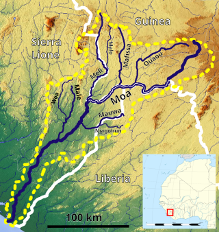
The Moa River is a river in west Africa. It arises in the highlands of Guinea and flows southwest, forming parts of the Guinea–Liberia and the Guinea – Sierra Leone borders. It flows into the Southern Province of Sierra Leone. Yenga, Tiwai Island and Sulima are located on the Moa.

The Kissi people are a West African ethnolinguistic group. They are the fourth largest ethnic group in Guinea, making up 6.2% of the population. Kissi people are also found in Liberia and Sierra Leone. They speak the Kissi language, which belongs to the Mel branch of the Niger–Congo language family. The Kissi are well known for making baskets and weaving on vertical looms. In past times they were also famous for their ironworking skills, as the country and its neighbors possess rich deposits of iron. Kissi smiths produced the famous "Kissi penny,"

United Nations Security Council resolution 1343, adopted unanimously on 7 March 2001, after recalling resolutions on Sierra Leone and the region, including resolutions 1132 (1997), 1171 (1998) and 1306 (2000), the Council demanded that Liberia end its support for rebels in Sierra Leone and threatened the imposition of wide-ranging sanctions unless the country complied with the Security Council.
Kissi Teng Chiefdom is a chiefdom in Kailahun District of Sierra Leone with a population of 30,455. Its largest town is Koindu, but its headquarters is in Kangama. The major industry in Kissi Teng Chiefdom is farming. The population of Kissi Teng Chiefdom is largely from the Kissi ethnic group.
Jawei Chiefdom is a chiefdom in Kailahun District of Sierra Leone with a population of 42,635. Its largest town and headquarters is Daru.
The United Nations Observer Mission in Sierra Leone (UNOMSIL) was a United Nations peacekeeping operation in Sierra Leone from 1998 to 1999 that was established with the passage of United Nations Security Council Resolution 1181. Its mission was to monitor the military and security situation in Sierra Leone. The mission was terminated in October 1999, when the Security Council authorized deployment of a new, and significantly larger peacekeeping operation, the United Nations Mission in Sierra Leone (UNAMSIL).

The Guinea–Sierra Leone border is 794 km in length and runs from the Atlantic Ocean in the west to the tripoint with Liberia in the east.

The Liberia–Sierra Leone border is 299 km in length and runs from the tripoint with Guinea in the north-east to the Atlantic Ocean in the south-west.
The RFDG Insurgency was an insurgency in Guinea by the RFDG, a rebel group supported by Liberia and the Sierra Leonean rebel group RUF. The fighting was closely connected to the Second Liberian Civil War and the Sierra Leone Civil War and primarily occurred on Guinea's borders with Liberia and Sierra Leone. Beginning in September 2000, some of the most intense fighting took place around the city of Guéckédou in December, before the level of violence decreased in 2001.

The Guinea–Sierra Leone relations are foreign relations between two neighbouring West African nations. After gaining independence initial relations between the two countries in the Cold War context turned to be tense due to conservative strategy of Sierra Leone and much more Pan-African and pro-socialist leanings of Guinea.
