
Micromeria douglasii, synonym Clinopodium douglasii, or yerba buena, is a rambling aromatic herb of western and northwestern North America, ranging from maritime Alaska southwards to California. The plant takes the form of a sprawling, mat-forming perennial, and is especially abundant close to the coast. The name "yerba buena" derives from Spanish for "good herb" and is applied to various other plants. In 2010, molecular evidence placed the species within the Clinopodium complex rather than Micromeria.

Yerba Buena Island sits in San Francisco Bay within the borders of the City and County of San Francisco. The Yerba Buena Tunnel runs through its center and connects the western and eastern spans of the San Francisco–Oakland Bay Bridge, linking the city with Oakland, California. Treasure Island is connected by a causeway to Yerba Buena Island. According to the United States Census Bureau, Yerba Buena Island and Treasure Island together have a land area of 0.901 square miles (2.33 km2) with a total population of 2,500 as of the 2010 census.

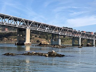
The San Francisco–Oakland Bay Bridge, known locally as the Bay Bridge, is a complex of bridges spanning San Francisco Bay in California. As part of Interstate 80 and the direct road between San Francisco and Oakland, it carries about 260,000 vehicles a day on its two decks. It has one of the longest spans in the United States.

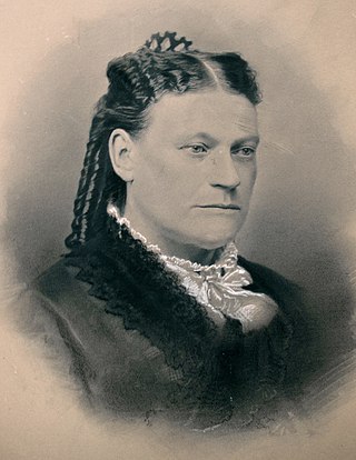
Samuel Brannan was an American settler, businessman, journalist, and prominent Mormon who founded the California Star, the first newspaper in San Francisco, California. He is considered the first to publicize the California Gold Rush and was its first millionaire. He used the profits from his stores to buy large tracts of real estate. He helped form the first vigilance committee in San Francisco and was disfellowshiped from the Church of Jesus Christ of Latter-day Saints because of his actions within the vigilance committee. Brannan's wife divorced him and he was forced to liquidate much of his real estate to pay her one-half of their assets. He died poor and in relative obscurity.

Yerba Buena Gardens is the name for two blocks of public parks located between Third and Fourth, Mission and Folsom Streets in downtown San Francisco, California. The first block bordered by Mission and Howard Streets was opened on October 11, 1993. The second block, between Howard and Folsom Streets, was opened in 1998, with a dedication to Martin Luther King Jr. by Mayor Willie Brown. A pedestrian bridge over Howard Street connects the two blocks, sitting on top of part of the Moscone Center convention center. The Yerba Buena Gardens were planned and built as the final centerpiece of the Yerba Buena Redevelopment Area which includes the Yerba Buena Center for the Arts. Yerba Buena Gardens Conservancy operates, manages, programs, and elevates the property on behalf of the City and County of San Francisco.
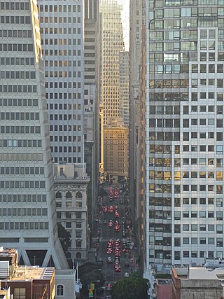
The Financial District is a neighborhood in San Francisco, California, United States, that serves as its main central business district and had 372,829 jobs according to U.S. census tracts as of 2012-2016. It is home to the city's largest concentration of corporate headquarters, law firms, insurance companies, real estate firms, savings and loan banks, and other financial institutions. Multiple Fortune 500 companies headquartered in San Francisco have their offices in the Financial District, including Wells Fargo, Salesforce, Uber, Gap, and Williams-Sonoma.

William Alexander Leidesdorff, Jr. was one of the earliest biracial-black U.S. citizens in California and one of the founders of the city that became San Francisco. A highly successful, enterprising businessman, he was a West Indian immigrant of African Cuban, possibly Carib, Danish/Swedish and Jewish ancestry. Leidesdorff became a United States citizen in New Orleans in 1834. He migrated to Alta California in 1841, then under Mexican rule, settling in Yerba Buena, a village of about 30 Mexican and European families.
Juana Briones de Miranda was a Californio ranchera, medical practitioner, and merchant, often remembered as the "Founding Mother of San Francisco", for her noted involvement in the early development of the city of San Francisco. Later in her life, she also played an important role in developing modern Palo Alto.

The Port of San Francisco is a semi-independent organization that oversees the port facilities at San Francisco, California, United States. It is run by a five-member commission, appointed by the Mayor and approved by the Board of Supervisors. The Port is responsible for managing the larger waterfront area that extends from the anchorage of the Golden Gate Bridge, along the Marina district, all the way around the north and east shores of the city of San Francisco including Fisherman's Wharf and the Embarcadero, and southward to the city line just beyond Candlestick Point. In 1968 the State of California, via the California State Lands Commission for the State-operated San Francisco Port Authority, transferred its responsibilities for the Harbor of San Francisco waterfront to the City and County of San Francisco / San Francisco Harbor Commission through the Burton Act AB2649. All eligible State port authority employees had the option to become employees of the City and County of San Francisco to maintain consistent operation of the Port of San Francisco.
The Castro Rocks are several rocks in Richmond, California protruding from the waters in San Francisco Bay between Castro Point and Red Rock Island.The rocks lie almost directly under the Richmond-San Rafael Bridge (I-580).

The Treasure Island Development is a 405-acre (164 ha) major redevelopment project under construction on Treasure Island and parts of Yerba Buena Island in San Francisco Bay between San Francisco and Oakland, within San Francisco city limits. The Treasure Island Development Authority (TIDA) is a nonprofit organization formed to oversee the economic development of the former naval station. Treasure Island's development was set to break ground during mid-2012. However, on April 12, 2013, The San Francisco Chronicle reported that the deal has collapsed, with the Chinese investors from China Development Bank and China Railway Construction Corporation withdrawing from the project. The Treasure Island Project is being developed by a joint venture between Lennar and Kenwood Investments. The development is expected to cost US$1.5 billion.

Yerba Buena was the original name of the settlement that later became San Francisco. Located near the northeastern end of the San Francisco Peninsula, between the Presidio of San Francisco and the Mission San Francisco de Asís, it was originally intended as a trading post for ships visiting San Francisco Bay. The settlement was arranged in the Spanish style around a plaza that remains as the present day Portsmouth Square.

The Barbary Coast Trail is a marked trail that connects a series of historic sites and several local history museums in San Francisco, California. Approximately 180 bronze medallions and arrows embedded in the sidewalk mark the 3.8-mile (6.1 km) trail.
Howard Street is a street in San Francisco's South of Market District (SoMa). It begins after branching off from Van Ness Avenue near the Mission District, and then runs parallel to and between of Mission Street and Folsom Street towards The Embarcadero. Howard Street has the Moscone Center, Rincon Plaza, Yerba Buena Center for the Arts, and The University of San Francisco along its corridor.
Domingo Marcucci Jugo, was a Venezuelan born 49er, shipbuilder and shipowner in San Francisco, California. He owned or captained some of the many steamships, steamboats, ferries, and sailing ships he built at San Francisco and elsewhere on the Pacific coast.
Steamboats operated in California on San Francisco Bay and the Sacramento–San Joaquin River Delta, and Sacramento River as early as November 1847, when the Sitka built by William A. Leidesdorff briefly ran on San Francisco Bay and up the Sacramento River to New Helvetia. After the first discovery of gold in California the first shipping on the bays and up the rivers were by ocean going craft that were able to sail close to the wind and of a shallow enough draft to be able to sail up the river channels and sloughs, although they were often abandoned by their crews upon reaching their destination. Regular service up the rivers, was provided primarily by schooners and launches to Sacramento and Stockton, that would take a week or more to make the trip.

Rincon Point, was a cape marking the southern extremity of Yerba Buena Cove in what is now San Francisco, California. Rincón is Spanish for "corner", and the point formed the southern corner of the cove.
Clarks Point was a cape on the north side of Yerba Buena Cove in what is now San Francisco, California.

The Old Ship Saloon is a historic bar dating back to the California gold rush when it operated out of the side of a ship run aground until the wreckage was buried and the current structure was built on top of it. It is located at 298 Pacific Avenue in the Jackson Square neighborhood of San Francisco. The Old Ship Saloon is listed as a stop along the Barbary Coast Trail.

