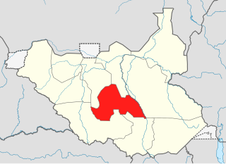
Lakes State is a state in South Sudan. It has an area of 43,595.08 km2. Rumbek is the capital of the state. Lakes is in the Bahr el Ghazal region of South Sudan, in addition to Northern Bahr el Ghazal, Western Bahr el Ghazal, and Warrap states. Bahr el Ghazal itself was a former province which was split from the Anglo-Egyptian mudiriyat, or province of Equatoria in 1948. The eastern border was the White Nile with Jonglei State on the opposite bank. To the northeast lied the Unity State. Other borders included Warrap State towards the northwest, Western Equatoria to the south and west, and Central Equatoria to the south.
Rumbek is the capital of Lakes State, central South Sudan.

Bor is a historic city in South Sudan’s central region, being the epicenter of national liberation revolution with multiple landmarks that tells the story. In Malual-Chaat barrack, statues of liberators and destroyed weapons are conserved and exhibited at historical heritage site. It has also served as the headquarters of Jonglei state. The city is situated on the east side of the White Nile at the southern extent of the sudd, South Sudan's vast central wetlands.
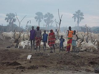
Dinka is a Nilotic dialect cluster spoken by the Dinka people, a major ethnic group of South Sudan. There are several main varieties, such as Padang, Rek, Agaar, Ciec, Apaak, Aliep, Bor, Hol, Nyarweng, Twic East and Twic Mayardit, which are distinct enough to require separate literary standards. Jaang, Jieng or Muonyjieng is used as a general term to cover all Dinka languages. Recently Akutmɛ̈t Latueŋ Thuɔŋjäŋ has proposed a unified written grammar of Dinka.
The Province of the Episcopal Church of South Sudan, formerly known as the Episcopal Church of Sudan, is a province of the Anglican Communion located in South Sudan. The province consists of eight Internal Provinces and 61 dioceses. The current archbishop and primate is Justin Badi Arama. It received the current naming after the inception of the Province of the Episcopal Church of Sudan, on 30 July 2017.

Tonj is a town located in Warrap State, Bahr el Ghazal in South Sudan. It is known by various names, including Kalkuel, Genanyuon, Jurkatac, Madiera, BaburWasaka, Genngeu, and Tonjdit. The town is bordered by Rumbek, Cueibet, Yambio, Bentiu, and Gogrial. As of 2010, its population is 17,340.
Ramciel is a location in South Sudan that will serve as the site of the future national capital. John Garang, the third president of Southern Sudan, allegedly wanted to place the national capital in Ramciel during his administration, but he died before South Sudan achieved independence and its largest city of Juba became the capital instead.
The Angakuei community belong to the people are members of the clan from Baidit Payam, Jonglei, South Sudan. The word Angakuei originates from the word Kuei, which means eagle. Abel Alier, the first South Sudanese to become the first vice President of The Sudan and the first president of the High Executive Council of Southern Sudan, is from the Angakuei clan. The name Alier originates from Lirpiou a deity that was worshipped by Angakueth and their brothers, Gwallɛi who are currently in Kolnyang Payam of Bor County.
Kolnyang is a Payam in Bor County, in Jonglei State, South Sudan. It is situated on the east side of the Bahr al Jabal River, to the south of Bor, South Sudan. Kolnyang’s Malual-Chaat was where the liberation revolution that led to South Sudan independence started. Both 105 Battalion commander Alier NhialMangardit and the first fallen hero of revolt Maker Jool were from Kolnyang. Kolnyang Payam is Bor county’s southernmost payam, bordering Central Equatoria State to southwest, Pibor Administrative Area to the east, Lake State to the west and Eastern Equatoria State to the southeast.
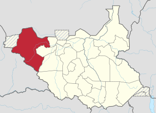
The Lol State was a state of South Sudan with the capital in Raga, that existed between 2 October 2015 and 22 February 2020. It was located in the Bahr el Ghazal region, which is in the northwest section of the country. Lol state bordered Haut-Mbomou and Haute-Kotto in the Central African Republic to the west, South Darfur and East Darfur in Sudan to the north, the disputed region of Kafia Kingi to the northwest, Aweil East State to the northeast, Aweil State to the east, Gbudwe State to the south, and Wau State to the southeast. The state was created alongside 27 other states after a decree issuing the creation of 28 states took place. It was dissolved at the conclusion of the South Sudanese Civil War.

Tonj State was a state in South Sudan that existed between 2 October 2015 and 22 February 2020. It was located in the Bahr el Ghazal region and it bordered Wau to the west, Gbudwe to the southwest, Gogrial to the northwest, Northern Liech to the northeast, Gok and Southern Liech to the east, and Western Lakes to the south and east.
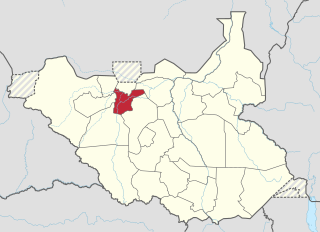
Gogrial State was a state in South Sudan that existed between 2 October 2015 and 22 February 2020. It was located in the Bahr el Ghazal region and it bordered Twic to the north, Aweil East to the northwest, Aweil to the west, Wau to the southwest, Tonj to the southeast, and Northern Liech to the northeast.

Eastern Lakes State was a state in South Sudan that existed between 2 October 2015 and 22 February 2020. It was located in the Bahr el Ghazal region and it bordered Southern Liech to the north, Western States to the west, Amadi to the southwest, Terekeka to the southeast, and Jonglei to the east.

Western Lakes was a state in South Sudan that existed between 2 October 2015 and 22 February 2020. It was located in the Bahr el Ghazal region and was part of the former state of Lakes State. It bordered Amadi State, Eastern Lakes State, Gbudwe State, Gok, Maridi State, Southern Liech State, and Tonj State.
Baidit is a Payam in Bor West County, in Jonglei State, South Sudan. It is situated on the east side of the Bahr al Jabal River a short distance north of Bor, South Sudan. Baidit is the county headquarters for Bor West County.

Tonj North County is an administrative area in Warrap State, South Sudan.
Tonj East County is an administrative area in Warrap State, South Sudan.
Tonj South County is an administrative area in Warrap State, South Sudan.
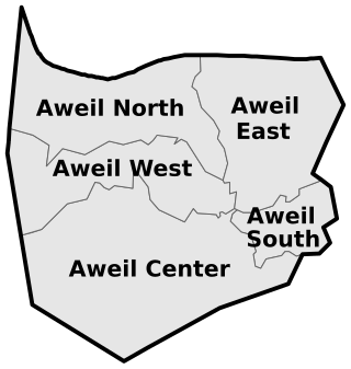
Aweil South County, sometimes called Paliet, is an administrative area in Northern Bahr el Ghazal, South Sudan bordering Warrap State to the south. It is located in the south eastern part of NBGs. It is also known by the name Paliet, and one of the counties consisting of three major Dinka tribal groups of Ajak, Boncuai and Kongdeer. It was founded in 2000, headquartered in Boncuai in a place called Mangar-Gier. In 2004, the headquarters were shifted to Malek Alel in Ajak. It is boardered to the north by Aweil East and to the west by Aweil Centre, to the south east by Gogrial State, and to the southwest by Western Barh el Ghazal state respectively.
Anuet payam is an independent payam situated at Bor South County in Jonglei State within South Sudan. Previously, Anuet village used to fall under Pariak boma in former Kolnyang payam.
