York, Nebraska

Last updated

York, Nebraska
York, Nebraska water tower from E 1.JPG
York water tower, May 2013
York County Nebraska Incorporated and Unincorporated areas York Highlighted.svg
Location within York County and Nebraska
Coordinates: 40°52′12″N97°35′34″W / 40.87000°N 97.59278°W / 40.87000; -97.59278
CountryUnited States
State Nebraska
County York
Area
[1]
  Total6.56 sq mi (16.99 km2)
  Land6.53 sq mi (16.92 km2)
  Water0.03 sq mi (0.07 km2)
Elevation
[2]
1,604 ft (489 m)
Population
 (2020)
  Total8,066
  Density1,235.03/sq mi (476.84/km2)
Time zone UTC−6 (Central (CST))
  Summer (DST) UTC−5 (CDT)
ZIP code
68467
Area code 402
FIPS code 31-54045
GNIS feature ID2397392 [2]
Interstates I-80.svg
U.S. Routes US 34.svg US 81.svg
Website cityofyork.net

York is a city in and the county seat of York County, Nebraska, United States. At the 2010 census, the city population was 7,766. It is the home of York University and the Nebraska Correctional Center for Women.

Contents

History

York was platted in 1869. [3] The city took its name from York County. [4]

In 1920, the Nebraska legislature established the State Reformatory for Women in York. The facility was expanded over the years; as of 2017, it operated as the Nebraska Correctional Center for Women, with a rated capacity of 275 beds. [5]

York College opened in the town in 1890. In 2022, the college attained university status, and thus became York University.

Demographics

Historical population
CensusPop.Note
1880 1,259
1890 3,405170.5%
1900 5,13250.7%
1910 6,23521.5%
1920 5,388−13.6%
1930 5,7126.0%
1940 5,383−5.8%
1950 6,17814.8%
1960 6,173−0.1%
1970 6,7789.8%
1980 7,72313.9%
1990 7,8842.1%
2000 8,0812.5%
2010 7,766−3.9%
2020 8,0663.9%
U.S. Decennial Census [6]
2013 Estimate [7]

2020 census

The 2020 United States census [8] counted 8,066 people, 3,354 households, and 2,021 families in York. The population density was 1,235.2 per square mile (476.7/km2). There were 3,707 housing units at an average density of 567.7 per square mile (219.1/km2). The racial makeup was 88.71% (7,155) white, 1.39% (112) black or African-American, 0.56% (45) Native American, 0.95% (77) Asian, 0.05% (4) Pacific Islander, 3.46% (279) from other races, and 4.88% (394) from two or more races. Hispanic or Latino of any race was 5.0% (402) of the population.

Of the 3,354 households, 24.7% had children under the age of 18; 53.3% were married couples living together; 25.0% had a female householder with no husband present. 35.2% of households consisted of individuals and 14.1% had someone living alone who was 65 years of age or older. The average household size was 2.2 and the average family size was 2.9.

23.2% of the population was under the age of 18, 9.8% from 18 to 24, 21.8% from 25 to 44, 22.2% from 45 to 64, and 19.8% who were 65 years of age or older. The median age was 40.3 years. For every 100 females, the population had 94.0 males. For every 100 females ages 18 and older, there were 89.7 males.

The 2016-2020 5-year American Community Survey [9] estimates show that the median household income was $58,125 (with a margin of error of +/- $7,758) and the median family income $79,282 (+/- $8,729). Males had a median income of $40,700 (+/- $6,625) versus $25,183 (+/- $3,155) for females. The median income for those above 16 years old was $31,846 (+/- $6,303). Approximately, 4.5% of families and 8.9% of the population were below the poverty line, including 9.0% of those under the age of 18 and 7.9% of those ages 65 or over.

2010 census

As of the census [10] of 2010, there were 7,766 people, 3,253 households, and 1,992 families living in the city. The population density was 1,350.6 inhabitants per square mile (521.5/km2). There were 3,633 housing units at an average density of 631.8 per square mile (243.9/km2). The racial makeup of the city was 94.9% White, 1.0% African American, 0.3% Native American, 0.7% Asian, 0.1% Pacific Islander, 1.8% from other races, and 1.2% from two or more races. Hispanic or Latino of any race were 4.4% of the population.

There were 3,253 households, of which 27.4% had children under the age of 18 living with them, 49.4% were married couples living together, 8.4% had a female householder with no husband present, 3.4% had a male householder with no wife present, and 38.8% were non-families. 33.4% of all households were made up of individuals, and 15.4% had someone living alone who was 65 years of age or older. The average household size was 2.26 and the average family size was 2.87.

The median age in the city was 39.4 years. 22.9% of residents were under the age of 18; 11.3% were between the ages of 18 and 24; 21.9% were from 25 to 44; 25.7% were from 45 to 64; and 18.2% were 65 years of age or older. The gender makeup of the city was 49.0% male and 51.0% female.

2000 census

As of the census of 2000, there were 8,081 people, 3,304 households, and 2,101 families living in the city. The population density was 1,433.6 inhabitants per square mile (553.5/km2). There were 3,532 housing units at an average density of 626.6 per square mile (241.9/km2). The racial makeup of the city was 96.76% White, 0.74% African American, 0.15% Native American, 0.74% Asian, 0.11% Pacific Islander, 0.58% from other races, and 0.92% from two or more races. Hispanic or Latino of any race were 1.56% of the population.

There were 3,304 households, out of which 29.0% had children under the age of 18 living with them, 53.3% were married couples living together, 7.8% had a female householder with no husband present, and 36.4% were non-families. 31.5% of all households were made up of individuals, and 16.4% had someone living alone who was 65 years of age or older. The average household size was 2.31 and the average family size was 2.90.

In the city, the population was spread out, with 23.7% under the age of 18, 11.7% from 18 to 24, 24.0% from 25 to 44, 22.4% from 45 to 64, and 18.2% who were 65 years of age or older. The median age was 38 years. For every 100 females, there were 90.1 males. For every 100 females age 18 and over, there were 86.6 males.

As of 2000 the median income for a household in the city was $36,069, and the median income for a family was $45,544. Males had a median income of $31,014 versus $20,086 for females. The per capita income for the city was $17,813. About 6.3% of families and 9.2% of the population were below the poverty line, including 9.1% of those under age 18 and 8.1% of those age 65 or over.

Geography

The city sits at the crossroads of Interstate 80, a major east–west highway, and U.S. Route 81, a major north–south highway.

According to the United States Census Bureau, the city has a total area of 5.77 square miles (14.94 km2), of which 5.75 square miles (14.89 km2) is land and 0.02 square miles (0.05 km2) is water. [11]

Climate

According to the Köppen Climate Classification system, York has a hot-summer humid continental climate, abbreviated "Dfa" on climate maps.

Climate data for York, Nebraska, 1991–2020 normals
MonthJanFebMarAprMayJunJulAugSepOctNovDecYear
Mean daily maximum °F (°C)34.9
(1.6)
39.7
(4.3)
51.8
(11.0)
63.5
(17.5)
73.3
(22.9)
83.7
(28.7)
87.1
(30.6)
85.0
(29.4)
79.2
(26.2)
66.5
(19.2)
51.6
(10.9)
38.7
(3.7)
62.9
(17.2)
Daily mean °F (°C)23.7
(−4.6)
28.0
(−2.2)
39.1
(3.9)
49.9
(9.9)
60.9
(16.1)
71.7
(22.1)
75.5
(24.2)
73.4
(23.0)
66.1
(18.9)
52.6
(11.4)
38.8
(3.8)
27.5
(−2.5)
50.6
(10.3)
Mean daily minimum °F (°C)12.6
(−10.8)
16.3
(−8.7)
26.3
(−3.2)
36.4
(2.4)
48.5
(9.2)
59.7
(15.4)
63.8
(17.7)
61.9
(16.6)
53.4
(11.9)
38.6
(3.7)
26.0
(−3.3)
16.3
(−8.7)
38.3
(3.5)
Average precipitation inches (mm)0.71
(18)
0.91
(23)
1.63
(41)
2.97
(75)
4.92
(125)
4.23
(107)
3.84
(98)
3.70
(94)
2.28
(58)
2.45
(62)
1.40
(36)
1.15
(29)
30.19
(766)
Average snowfall inches (cm)4.9
(12)
9.1
(23)
3.9
(9.9)
1.1
(2.8)
0.0
(0.0)
0.0
(0.0)
0.0
(0.0)
0.0
(0.0)
0.0
(0.0)
0.5
(1.3)
1.6
(4.1)
6.7
(17)
27.8
(70.1)
Average precipitation days (≥ 0.01 in)6.16.58.410.713.511.410.110.98.48.44.56.6105.5
Average snowy days (≥ 0.1 in)4.05.22.20.70.00.00.00.00.00.21.13.817.2
Source: NOAA [12]

Culture

City Auditorium, October 2009 York City Auditorium (Nebraska) 2.jpg
City Auditorium, October 2009

The Art Deco York Auditorium (1940) was designed by Meginnis and Schaumberg.

In 2001 Lee's Legendary Marbles and Collectables was established and as of 2023 is recognized as the World's Largest Collection of Marbles. [13]

Education

York Public Schools are part of the York Public Schools School District. Schools in the district include York Elementary School, York Middle School and York High School.

York has two parochial schools. Emmanuel-Faith Lutheran School opened in 1957. The pre-school is located at Faith Lutheran Church in York, while grades K-8 are located in a school attached to Emmanuel Lutheran Church. [14] St. Joseph Catholic School, opened in 1890, educates children grades PK-8. [15]

York University is a private college affiliated with the Churches of Christ and located in York. It was founded in 1890.

Media

York fielded a number of newspapers in the 1800s. On January 1, 1883, the York Democrat was created from a previous paper, the York Tribune. The York Republican was another newspaper that flourished during this time and was notable for its large circulation. [16] York's current newspaper is the York News-Times .

York has two radio stations that have been locally owned since they went on the air in 1954: KAWL (AM 1370) and KTMX (FM 1970), providing news, sports, music and entertainment to York and adjacent counties.

Notable people

See also

Related Research Articles

<span class="mw-page-title-main">Fairfield, Nebraska</span> City in Nebraska, United States

Fairfield is a city in Clay County, Nebraska, United States. The population was 387 at the 2010 census. It is part of the Hastings, Nebraska Micropolitan Statistical Area.

<span class="mw-page-title-main">Boys Town, Nebraska</span> Village in Douglas County, Nebraska, United States

Boys Town is a village in Douglas County, Nebraska, United States. The population was 410 at the 2020 census. Boys Town is an enclave and a suburb of Omaha.

<span class="mw-page-title-main">Ralston, Nebraska</span> City in Douglas County, Nebraska, United States

Ralston is a city in Douglas County, Nebraska, United States. The population was 6,494 at the 2020 census. A suburb of Omaha, Ralston is surrounded on three sides by the city of Omaha by 84th, 72nd, and L Streets, and by Sarpy County on the south side.

<span class="mw-page-title-main">Waterloo, Nebraska</span> Village in Douglas County, Nebraska, United States

Waterloo is a village in Douglas County, Nebraska, United States. The population was 935 at the 2020 census.

<span class="mw-page-title-main">Beaver City, Nebraska</span> City in Nebraska, United States

Beaver City is a city in Furnas County, on the southern border of Nebraska, United States. The population was 609 at the 2010 census. It is the county seat of Furnas County.

<span class="mw-page-title-main">Cortland, Nebraska</span> Village in Nebraska, United States

Cortland is a village in Gage County, Nebraska, United States. The population was 504 at the 2020 census.

<span class="mw-page-title-main">Burwell, Nebraska</span> City in Nebraska, United States

Burwell is a city in Garfield County, Nebraska, United States. The population was 1,210 at the 2010 census. It is the county seat of Garfield County.

<span class="mw-page-title-main">Ogallala, Nebraska</span> City in Nebraska, United States

Ogallala is a city in and the county seat of Keith County, Nebraska, United States. The population was 4,878 at the 2020 census, up from 4,737 at the 2010 census. In the days of the Nebraska Territory, the city was a stop on the Pony Express and later along the transcontinental railroad. The Ogallala Formation that carries the Ogallala Aquifer was named after the city.

<span class="mw-page-title-main">Waverly, Nebraska</span> Village in Nebraska, United States

Waverly is a village in Lancaster County, Nebraska, United States. It is part of the Lincoln, Nebraska Metropolitan Statistical Area. The population was 4,279 at the 2020 census.

<span class="mw-page-title-main">Syracuse, Nebraska</span> City in Nebraska, United States

Syracuse is a city in Otoe County, Nebraska, United States. The population was 1,941 at the 2020 census.

<span class="mw-page-title-main">Pierce, Nebraska</span> City in Nebraska, United States

Pierce is a city in and county seat of Pierce County, Nebraska, United States. The population was 1,767 at the 2010 census.

<span class="mw-page-title-main">Humphrey, Nebraska</span> City in Platte County, Nebraska, United States

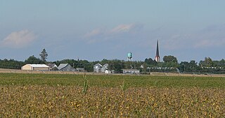
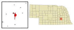
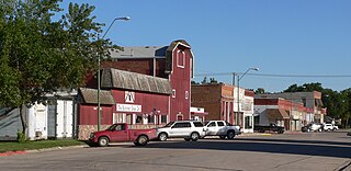
Humphrey is a city in Platte County, Nebraska, United States. The population was 760 at the 2010 census.

<span class="mw-page-title-main">Crete, Nebraska</span> City in Saline County, Nebraska, United States

Crete is a city in and the most populous municipality of Saline County, Nebraska, United States. The population was 7,099 at the 2020 census. The city is home to Doane University.

<span class="mw-page-title-main">Bellevue, Nebraska</span> City in Sarpy County, Nebraska, United States

Bellevue is a suburban city in Sarpy County, Nebraska, United States. It is part of the Omaha–Council Bluffs metropolitan area, and had a population of 64,176 as of the 2020 census, making it the 3rd most populous city in Nebraska, behind Omaha and Lincoln, and the second largest city in the U.S. named "Bellevue," behind Bellevue, Washington.

<span class="mw-page-title-main">La Vista, Nebraska</span> City in Sarpy County, Nebraska, United States

La Vista is a city in Sarpy County, Nebraska, United States. The population was 16,746 at the 2020 census, making it the 12th most populous city in Nebraska. The city was incorporated on February 23, 1960.

<span class="mw-page-title-main">Seward, Nebraska</span> City in and county seat of Seward County, Nebraska, United States

Seward is a city and county seat of Seward County, Nebraska, United States. The population was 6,964 at the 2010 census. Seward is part of the Lincoln, Nebraska Metropolitan Statistical Area.

<span class="mw-page-title-main">Hay Springs, Nebraska</span> City in Nebraska, United States

Hay Springs is a city in Sheridan County in the state of Nebraska, in the Great Plains region of the United States. The population was 570 at the 2010 census.

<span class="mw-page-title-main">Blair, Nebraska</span> City in and county seat of Washington County, Nebraska, United States

Blair is a city in and the county seat of Washington County, Nebraska, United States. The population was 7,990 at the 2010 census. Blair is a part of the Omaha-Council Bluffs Metropolitan Statistical Area.

<span class="mw-page-title-main">Waco, Nebraska</span> Village in York County, Nebraska, United States

Waco is a village in York County, Nebraska, United States. The population was 236 at the 2010 census.

<span class="mw-page-title-main">Newman Grove, Nebraska</span> City in Platte County, Nebraska, United States

Newman Grove is a city in Madison and Platte counties in Nebraska, United States. The population was 721 at the 2010 census.

References

  1. "ArcGIS REST Services Directory". United States Census Bureau. Retrieved September 18, 2022.
  2. 1 2 U.S. Geological Survey Geographic Names Information System: York, Nebraska
  3. "York, York County". Center for Advanced Land Management Information Technologies. University of Nebraska. Retrieved August 24, 2014.
  4. Chicago and North Western Railway Company (1908). A History of the Origin of the Place Names Connected with the Chicago & North Western and Chicago, St. Paul, Minneapolis & Omaha Railways. p. 142.
  5. "Nebraska Correctional Center for Women". Nebraska Department of Correctional Services. Retrieved August 11, 2017.
  6. United States Census Bureau. "Census of Population and Housing" . Retrieved October 16, 2013.
  7. "Population Estimates". United States Census Bureau . Retrieved July 17, 2014.
  8. "Explore Census Data". data.census.gov. Retrieved December 18, 2023.
  9. "Explore Census Data". data.census.gov. Retrieved December 18, 2023.
  10. "U.S. Census website". United States Census Bureau . Retrieved June 24, 2012.
  11. "US Gazetteer files 2010". United States Census Bureau. Archived from the original on February 20, 2011. Retrieved June 24, 2012.
  12. "U.S. Climate Normals Quick Access – Station: York 3N, NE". National Oceanic and Atmospheric Administration. Retrieved February 4, 2023.
  13. "World's Largest Collection of Marbles: world record in York, Nebraska". www.worldrecordacademy.org. July 11, 2023. Retrieved April 8, 2024.
  14. "Information". Archived from the original on October 12, 2013. Retrieved October 5, 2013.
  15. "History of St. Joseph Catholic School". yorkstjosephschool.org. Retrieved April 5, 2019.
  16. Our Illustrated York, NE-reprinted by the York County Historical Association 1997
  17. "Biographies:Congressman Doug Bereuter". www.nato.int. Retrieved November 9, 2022.
  18. Howard, John N. "Presidents of the 1930s". Optics & Photonics News. November 2009. Retrieved 2010-10-25.
  19. Shirley Ross obit The Lincoln Star (March 14, 1975)