Papillion, Nebraska

Last updated

Papillion, Nebraska
Downtown Papillion, Nebraska.jpg
Downtown Papillion along
Nebraska Highway 85, June 2011
Sarpy County Nebraska Incorporated and Unincorporated areas Papillion Highlighted.svg
Location of Papillion within Nebraska and Sarpy County
Coordinates: 41°08′22″N96°04′20″W / 41.13944°N 96.07222°W / 41.13944; -96.07222
CountryUnited States
State Nebraska
County Sarpy
Area
[1]
  Total12.27 sq mi (31.77 km2)
  Land11.99 sq mi (31.06 km2)
  Water0.27 sq mi (0.70 km2)
Elevation
[2]
1,032 ft (315 m)
Population
 (2020)
  Total24,159
  Density2,014.26/sq mi (777.73/km2)
Time zone UTC−6 (Central (CST))
  Summer (DST) UTC−5 (CDT)
ZIP Codes
68046, 68133, 68157
Area code 402
FIPS code 31-38295
GNIS feature ID2396139 [2]
Website papillion.org

Papillion is a city in and the county seat of Sarpy County, Nebraska, United States. The city developed in the 1870s as a railroad town and suburb of Omaha. [3] The city is part of the larger five-county metro area of Omaha. Papillion's population was 24,159 at the 2020 census, making it the 7th most populous city in Nebraska. Its growth since the late 20th century has reflected Omaha's.

Contents

Description

The city was named after the creek of the same name which flows through its center; this had been named by early French explorers, as France had claimed this territory through the eighteenth century. The name Papillion is derived from the French term (papillon) for butterfly. According to local tradition, the early French explorers named the creek as Papillon because they saw so many butterflies along its grassy banks. [4] The spelling was changed through a transliteration of the French word.

Papillion was platted in 1870 when the railroad was extended to that point. [5] Papillion (sometimes referred to as "Papio" by its residents) is one of the last of the late 18th-century, Paris-inspired frontier cities left in the Midwestern United States.

Halleck Park, a recreation area in the heart of the city, includes many trails, open spaces, trees and a number of areas of interest, including Papio Fun Park, Papio Bay Aquatic Park, Papio Pool, and Papio Bowl. The park also offers tennis courts, volleyball courts, playgrounds, "The Duck Pond", Monarch Field ("The Pit"), and E.A. Fricke Field.

It also has nine other softball diamonds within the park for youth. The diamonds are sited on three fields: Halleck, Blonde, and Papio Bay. Village Park, Papio Bay Aquatic Center (including two water slides and a zero depth pool) and Walnut Creek recreational park are among the other recreational amenities in the city.

Papillion City Hall, June 2011 Papillion, Nebraska Municipal Building.jpg
Papillion City Hall, June 2011

Papillion Middle School is in the downtown area south of Papio Creek; the building formerly was used as the high school until August 1971. The former junior high was located directly west, across the street.

Also downtown are the Old A.W. Clarke banking house, Sump Memorial Library, Portal One-Room School House, Papillion Municipal Building (Sarpy County Courthouse until 1970), and the John Sautter House. Other areas of interest in Papillion include the Sarpy County Court House and Jail, Shadow Lake Towne Center, and Midlands Hospital, all along Nebraska Highway 370 in the southern portion of the city.

Papillion has a Triple-A Minor League Baseball team. Werner Park, located 3 miles (4.8 km) west of the city on Highway 370 in unincorporated Sarpy County, opened in 2011 as the new home of the Omaha Storm Chasers of the Pacific Coast League. The Storm Chasers were formerly the Omaha Royals; after 42 years at Rosenblatt Stadium in south Omaha, the team moved out following the 2010 season and changed their nickname. They have been the only Triple-A affiliate of the Kansas City Royals, an expansion club that entered the American League in 1969. In conjunction with Major League Baseball's restructuring of Minor League Baseball in 2021, the Storm Chasers were placed into the new Triple-A East. [6]

Geography

According to the U.S. Census Bureau, the city has a total area of 6.47 square miles (16.76 km2), of which 6.45 square miles (16.71 km2) is land and 0.02 square miles (0.05 km2) is water. [7]

Climate

Climate data for Papillion, Nebraska
MonthJanFebMarAprMayJunJulAugSepOctNovDecYear
Mean daily maximum °F (°C)32
(0)
38
(3)
50
(10)
63
(17)
74
(23)
84
(29)
87
(31)
85
(29)
77
(25)
65
(18)
48
(9)
35
(2)
62
(16)
Mean daily minimum °F (°C)12
(−11)
18
(−8)
28
(−2)
40
(4)
51
(11)
61
(16)
66
(19)
64
(18)
54
(12)
41
(5)
28
(−2)
16
(−9)
40
(4)
Average precipitation inches (mm)0.77
(20)
0.80
(20)
2.13
(54)
2.94
(75)
4.44
(113)
3.95
(100)
3.86
(98)
3.21
(82)
3.17
(81)
2.21
(56)
1.82
(46)
0.92
(23)
30.22
(768)
Source: The Weather Channel [8]

Demographics

Historical population
CensusPop.Note
1880 444
1890 60035.1%
1900 594−1.0%
1910 6245.1%
1920 6666.7%
1930 7187.8%
1940 7636.3%
1950 1,03435.5%
1960 2,235116.2%
1970 5,606150.8%
1980 6,39914.1%
1990 10,37262.1%
2000 16,36357.8%
2010 18,89415.5%
2020 24,15927.9%
U.S. Decennial Census [9]

2020 census

The 2020 United States census [10] counted 24,159 people, 8,934 households, and 6,508 families in Papillion. The population density was 2,014.9 per square mile (777.8/km2). There were 9,214 housing units at an average density of 768.5 per square mile (296.7/km2). The racial makeup was 84.65% (20,451) white, 3.17% (766) black or African-American, 0.46% (112) Native American, 1.65% (398) Asian, 0.06% (15) Pacific Islander, 2.16% (521) from other races, and 7.85% (1,896) from two or more races. Hispanic or Latino of any race was 6.0% (1,659) of the population.

Of the 8,934 households, 31.9% had children under the age of 18; 60.9% were married couples living together; 22.9% had a female householder with no husband present. 23.2% of households consisted of individuals and 10.2% had someone living alone who was 65 years of age or older. The average household size was 2.7 and the average family size was 3.1.

25.0% of the population was under the age of 18, 8.1% from 18 to 24, 26.6% from 25 to 44, 26.5% from 45 to 64, and 14.5% who were 65 years of age or older. The median age was 38.5 years. For every 100 females, the population had 99.1 males. For every 100 females ages 18 and older, there were 95.7 males.

The 2016-2020 5-year American Community Survey [11] estimates show that the median household income was $90,000 (with a margin of error of +/- $5,784) and the median family income $107,942 (+/- $7,167). Males had a median income of $50,140 (+/- $5,121) versus $34,647 (+/- $3,077) for females. The median income for those above 16 years old was $40,496 (+/- $2,017). Approximately, 2.9% of families and 4.0% of the population were below the poverty line, including 4.3% of those under the age of 18 and 5.5% of those ages 65 or over.

2010 census

As of the 2010 census, [12] there were 18,894 people, 6,925 households, and 5,079 families living in the city. The population density was 2,929.3 inhabitants per square mile (1,131.0/km2). There were 7,240 housing units at an average density of 1,122.5 per square mile (433.4/km2). The racial makeup of the city was 90.7% White, 3.3% African American, 0.4% Native American, 1.5% Asian, 1.5% from other races, and 2.7% from two or more races. Hispanic or Latino people of any race were 5.2% of the population.

There were 6,925 households, of which 38.1% had children under the age of 18 living with them, 59.5% were married couples living together, 10.1% had a female householder with no husband present, 3.7% had a male householder with no wife present, and 26.7% were non-families. 22.5% of all households were made up of individuals, and 9% had someone living alone who was 65 years of age or older. The average household size was 2.68 and the average family size was 3.15.

The median age in the city was 36.8 years. 27.3% of residents were under the age of 18; 9.1% were between the ages of 18 and 24; 24.3% were from 25 to 44; 28.5% were from 45 to 64; and 11% were 65 years of age or older. The gender makeup of the city was 48.8% male and 51.2% female.

Politics

Papillion is divided into four wards, with two councilmembers elected from each. One seat for each ward is up for election every two years, with each term lasting four years. The mayor is the head of the city council and is elected at-large to four-year terms. The council meets every two weeks. Following former Mayor James Blinn's resignation on July 7, 2009, city council president David Black succeeded to become mayor of Papillion. He was elected in 2010 for his first full term; as of October 2022, he had been mayor for 13 years, running unopposed in the 2022 election cycle. [13]

Schools

Papillion is part of the Papillion-La Vista Public School District, which includes two high schools, three middle schools and fifteen public elementary schools. Papillion-La Vista South High School, the newer of the two high schools, opened in 2003. It is located in southwest Papillion while Papillion-La Vista High School, opened in 1971, is located in the northern part of the city close to the LaVista border. The school district has well over 8,000 students and is one of the fastest-growing districts in Nebraska.

Papillion is home to Nebraska Christian College, accredited by the Association for Biblical Higher Education. [14]

Transportation

Transit service to the city is provided by Metro Transit. Route 93 serves the city on weekdays. [15]

Notable people

See also

Related Research Articles

<span class="mw-page-title-main">Sarpy County, Nebraska</span> County in Nebraska, United States

Sarpy County is a county located in the U.S. state of Nebraska. As of the 2020 census, the population was 190,604, making it the third-most populous county in Nebraska. Its county seat is Papillion.

<span class="mw-page-title-main">Douglas County, Nebraska</span> County in Nebraska, United States

Douglas County is a county located in the U.S. state of Nebraska. As of the 2020 United States Census, the population is 584,526. It is the state's most populous county, home to well over one-fourth of Nebraska's residents. Its county seat is Omaha, the state's largest city. The county was established in 1854 and named after Stephen A. Douglas (1813–1861), who was then serving as Senator from Illinois.

<span class="mw-page-title-main">Dakota County, Nebraska</span> County in Nebraska, United States

Dakota County is a county in the U.S. state of Nebraska. As of the 2020 United States Census, the population was 21,582. Its county seat is Dakota City.

<span class="mw-page-title-main">Cass County, Nebraska</span> County in Nebraska, United States

Cass County is a county in the U.S. state of Nebraska. As of the 2020 United States Census, the population was 26,598. Its county seat and largest city is Plattsmouth. The county was formed in 1855, and was named for General Lewis Cass, an American military officer, politician, and statesman.

<span class="mw-page-title-main">Carter Lake, Iowa</span> City in Iowa, United States

Carter Lake is a city in Pottawattamie County, Iowa, United States. A suburb of Omaha, Nebraska, it sits surrounding the south and west sides of the region's major airport, Eppley Airfield. It is separated from the rest of Iowa by the Missouri River, effectively making it an exclave. The population was 3,791 at the 2020 census.

<span class="mw-page-title-main">Decatur, Nebraska</span> Village in Nebraska, United States

Decatur is a village in Burt County, Nebraska, United States, adjacent to the upper Missouri River. The population was 481 at the 2010 census. This town is named after one of its incorporators, Stephen Decatur. It developed around a trading post established by Colonel Peter Sarpy, the namesake for Sarpy County in the state.

<span class="mw-page-title-main">Fremont, Nebraska</span> City in Nebraska, United States

Fremont is a city and county seat of Dodge County in the eastern portion of the state of Nebraska in the Midwestern United States. The population was 27,141 at the 2020 census, making it the 6th most populous city in Nebraska. Fremont is the home of Midland University.

<span class="mw-page-title-main">Ralston, Nebraska</span> City in Douglas County, Nebraska, United States

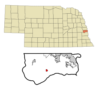
Ralston is a city in Douglas County, Nebraska, United States. The population was 6,494 at the 2020 census. A suburb of Omaha, Ralston is surrounded on three sides by the city of Omaha by 84th, 72nd, and L Streets, and by Sarpy County on the south side.

<span class="mw-page-title-main">Ogallala, Nebraska</span> City in Nebraska, United States

Ogallala is a city in and the county seat of Keith County, Nebraska, United States. The population was 4,878 at the 2020 census, up from 4,737 at the 2010 census. In the days of the Nebraska Territory, the city was a stop on the Pony Express and later along the transcontinental railroad. The Ogallala Formation that carries the Ogallala Aquifer was named after the city.

<span class="mw-page-title-main">Pierce, Nebraska</span> City in Nebraska, United States

Pierce is a city in and county seat of Pierce County, Nebraska, United States. The population was 1,767 at the 2010 census.

<span class="mw-page-title-main">Bassett, Nebraska</span> City in and county seat of Rock County, Nebraska, United States

Bassett is a city in Rock County, Nebraska, United States. The population was 538 at the 2020 census. It is the county seat of Rock County.

<span class="mw-page-title-main">Bellevue, Nebraska</span> City in Sarpy County, Nebraska, United States

Bellevue is a suburban city in Sarpy County, Nebraska, United States. It is part of the Omaha–Council Bluffs metropolitan area, and had a population of 64,176 as of the 2020 census, making it the 3rd most populous city in Nebraska, behind Omaha and Lincoln, and the second largest city in the U.S. named "Bellevue," behind Bellevue, Washington.

<span class="mw-page-title-main">Chalco, Nebraska</span> CDP in Nebraska, United States

Chalco is a census-designated place (CDP) in northern Sarpy County, Nebraska, United States, and an adjacent suburb of Omaha, with La Vista located to the southeast. The population was 11,064 at the 2020 census.

<span class="mw-page-title-main">Gretna, Nebraska</span> City in Sarpy County, Nebraska, United States

Gretna is a city in Sarpy County, Nebraska, United States. The population was 5,083 at the 2020 census.

<span class="mw-page-title-main">La Vista, Nebraska</span> City in Sarpy County, Nebraska, United States

La Vista is a city in Sarpy County, Nebraska, United States. The population was 16,746 at the 2020 census, making it the 12th most populous city in Nebraska. The city was incorporated on February 23, 1960.

<span class="mw-page-title-main">Springfield, Nebraska</span> City in Sarpy County, Nebraska, United States

Springfield is a city in Sarpy County, Nebraska, United States. The population was 1,501 at the 2020 census.

<span class="mw-page-title-main">Blair, Nebraska</span> City in and county seat of Washington County, Nebraska, United States

Blair is a city in and the county seat of Washington County, Nebraska, United States. The population was 7,990 at the 2010 census. Blair is a part of the Omaha-Council Bluffs Metropolitan Statistical Area.

<span class="mw-page-title-main">Wayne, Nebraska</span> City in Wayne County, Nebraska, United States

Wayne is a city in Wayne County, Nebraska, United States. The population was 5,660 at the 2010 census. It is the county seat of Wayne County and the home of Wayne State College.

<span class="mw-page-title-main">York, Nebraska</span> City in and county seat of York County, Nebraska, United States

York is a city in and the county seat of York County, Nebraska, United States. At the 2010 census, the city population was 7,766. It is the home of York University and the Nebraska Correctional Center for Women.

<span class="mw-page-title-main">Wakefield, Nebraska</span> City in Dixon and Wayne counties in Nebraska, United States

Wakefield is a city in Dixon and Wayne Counties in the State of Nebraska. The population was 1,451 at the 2010 census.

References

  1. "ArcGIS REST Services Directory". United States Census Bureau. Retrieved September 18, 2022.
  2. 1 2 U.S. Geological Survey Geographic Names Information System: Papillion, Nebraska
  3. "Find a County". National Association of Counties. Retrieved June 7, 2011.
  4. usgennet.org - Nebraska place names - Sarpy County - accessed 2011-09-08
  5. "Papillion, Sarpy County". Center for Advanced Land Management Information Technologies. University of Nebraska. Retrieved August 23, 2014.
  6. Mayo, Jonathan (February 12, 2021). "MLB Announces New Minors Teams, Leagues". Major League Baseball. Retrieved February 12, 2021.
  7. "US Gazetteer files 2010". United States Census Bureau. Archived from the original on January 25, 2012. Retrieved June 24, 2012.
  8. "Monthly Averages for Papillion, Nebraska". Weather.com. 2010. Retrieved March 31, 2010.
  9. United States Census Bureau. "Census of Population and Housing" . Retrieved June 22, 2013.
  10. "Explore Census Data". data.census.gov. Retrieved December 18, 2023.
  11. "Explore Census Data". data.census.gov. Retrieved December 18, 2023.
  12. "U.S. Census website". United States Census Bureau . Retrieved June 24, 2012.
  13. Branting, Adam (October 4, 2022). "Mayor David Black unchallenged as Papillion's CEO". The Daily Nonpareil - Council Bluffs, Iowa. Retrieved March 7, 2023.
  14. "Consumer Information". Nebraska Christian College. Retrieved 2017-04-26.
  15. "Metro Map" . Retrieved July 21, 2023.