Carter Lake, Iowa

Last updated

Carter Lake, Iowa
Carter Lake, Iowa City Offices.jpg
City Office Building in Carter Lake, Iowa
Pottawattamie County Iowa Incorporated and Unincorporated areas Carter Lake Highlighted.svg
Location of Carter Lake, Iowa
Carter-lake-map.png
U.S. Census Map
Coordinates: 41°17′18″N95°55′01″W / 41.28833°N 95.91694°W / 41.28833; -95.91694
Country Flag of the United States (23px).png  United States
State Flag of Iowa.svg  Iowa
County Pottawattamie
Government
  TypeMayor-council
Area
[1]
  Total2.02 sq mi (5.23 km2)
  Land1.79 sq mi (4.65 km2)
  Water0.22 sq mi (0.58 km2)
Elevation
[2]
974 ft (297 m)
Population
 (2020)
  Total3,791
  Density2,113.15/sq mi (815.71/km2)
Time zone UTC-6 (Central (CST))
  Summer (DST) UTC-5 (CDT)
ZIP code
51510
Area code 712
FIPS code 19-11215
GNIS feature ID2393756 [2]
Website www.cityofcarterlake.com

Carter Lake is a city in Pottawattamie County, Iowa, United States. A suburb of Omaha, Nebraska, it sits surrounding the south and west sides of the region's major airport, Eppley Airfield. It is separated from the rest of Iowa by the Missouri River, effectively making it an exclave. The population was 3,791 at the 2020 census. [3]

Contents

History

Carter Lake is an example of the border irregularities of the United States, being the only city in Iowa located west of the Missouri River. In March 1877, a flood redirected the course of the river 1.25 mi (2 km) to the southeast. The remnants of the old river course, called Saratoga Bend, became an oxbow lake, named Carter Lake. [4] [5] [6] Soon after the formation of the lake, the site became a flourishing recreational area. It included "a boathouse at the foot of Locust street, hotels and club houses were numerous and the lake was the scene of many a pleasant rowing and fishing party." [7]

In 1892, after extensive litigation between Iowa and Nebraska, the Supreme Court of the United States ruled that Carter Lake belonged to Iowa in Nebraska v. Iowa, 143 U.S. 359 (1892). [8] Although the general rule is that state boundaries follow gradual changes in the course of a river, the Court ruled that an exception exists when a river avulses one of its bends. In 1972, the Supreme Court made another ruling on the circumstances of Carter Lake when it ruled on a boundary dispute between the two states in Nebraska v. Iowa, 406 U.S. 117 (1972). [9]

Although Carter Lake was legally considered part of Council Bluffs, residents paid city taxes but lacked the basic city services enjoyed by residents east of the Missouri River. [10] The community successfully seceded from Council Bluffs in the 1920s, intending to become part of Omaha, Nebraska, [10] but Omaha did not want to pay to extend sewers or water lines.[ citation needed ]

On July 2, 1930, Carter Lake was incorporated as a city, in the state of Iowa. [11] :10

Two early, separate amusement parks were located in Carter Lake: from 1905 to 1917, there was the Courtland Beach Amusement Park, and from 1917 to 1933, the Lakeview Amusement Park. The Munchoff Brothers, who were the original operators of Omaha's Krug Park, ran both parks; in 1917, they moved rides from Courtland to Lakeview. In 1945, one of the brothers donated the rides from the old parks to the World War II metal drives. [12]

In the 1930s and '40s, Carter Lake became a gambling hot spot, as law enforcement was limited and because of its important location. At The Chez Paree, you "could listen to Sophie Tucker, have the best prime rib in town and enjoy a gambling raid or two." Patrons could "bet on any horse race in the United States," and the business was described as "the most active casino between Chicago and the West Coast." [13] [11] :66

The mistaken belief that a defendant corporation located in Carter Lake was a legal resident of Nebraska resulted in another U.S. Supreme Court case, Owen Equipment & Erection Co. v. Kroger , 437 U.S. 365 (1978). The case clarified the law regarding ancillary jurisdiction, which allows claims based on state law to be heard in a federal court when related to a claim based on federal law. [14] [15]

Geography

Iowa welcome sign on Abbott Drive (Iowa Highway 165), the main road between downtown Omaha and Eppley Airfield Iowa Highway 165.jpg
Iowa welcome sign on Abbott Drive (Iowa Highway 165), the main road between downtown Omaha and Eppley Airfield

The city is surrounded on three sides by Omaha, Nebraska, and on the fourth by the Missouri River. [16]

According to the United States Census Bureau, the city has a total area of 2.02 square miles (5.23 km2), of which 1.87 square miles (4.84 km2) is land and 0.15 square miles (0.39 km2) is water. [17]

Carter Lake creates a geographic oddity for travelers going to Eppley Airfield, which it surrounds on the south and west. Consequently, travelers going to Eppley Airfield from anywhere except North Omaha will go through Carter Lake, Iowa. It is reported to have caused confusion when travelers not used to the area go through and see a "Welcome to Iowa" sign on their way to and from the airport. [10]

Demographics

Historical populations
YearPop.±%
1940 846    
1950 1,183+39.8%
1960 2,287+93.3%
1970 3,268+42.9%
1980 3,438+5.2%
1990 3,200−6.9%
2000 3,248+1.5%
2010 3,785+16.5%
2020 3,791+0.2%
Source: "U.S. Census website". United States Census Bureau . Retrieved March 29, 2020. and Iowa Data Center
Source:
U.S. Decennial Census [18] [3]
The population of Carter Lake, Iowa from US census data Carter LakeIowaPopPlot.png
The population of Carter Lake, Iowa from US census data

2000 census

As of the census [19] of 2000, there were 3,248 people, 1,221 households, and 914 families residing in the city. The population density was 1,799.7 inhabitants per square mile (694.9/km2). There were 1,292 housing units at an average density of 715.9 per square mile (276.4/km2). The racial makeup of the city was 96.71% White, 0.25% African American, 0.74% Native American, 0.25% Asian, 0.86% from other races, and 1.20% from two or more races. 2.89% of the population were Hispanic or Latino of any race.

There were 1,221 households, out of which 32.3% had children under the age of 18 living with them, 55.4% were married couples living together, 13.3% had a female householder with no husband present, and 25.1% were non-families. 20.1% of all households were made up of individuals, and 7.5% had someone living alone who was 65 years of age or older. The average household size was 2.66 and the average family size was 3.04.

Age/gender breakdown: 25.9% under the age of 18, 8.0% from 18 to 24, 29.8% from 25 to 44, 24.3% from 45 to 64, and 12.0% who were 65 years of age or older. The median age was 37 years. For every 100 females, there were 100.1 males. For every 100 females age 18 and over, there were 94.4 males.

The median income for a household in the city was $37,851, and the median income for a family was $42,794. Males had a median income of $30,946 versus $23,309 for females. The per capita income for the city was $18,758. 7.1% of the population and 4.9% of families were below the poverty line. Out of the total population, 11.6% of those under the age of 18 and 2.9% of those 65 and older were living below the poverty line.

2010 census

As of the census [20] of 2010, there were 3,785 people, 1,388 households, and 997 families residing in the city. The population density was 2,024.1 inhabitants per square mile (781.5/km2). There were 1,481 housing units at an average density of 792.0 per square mile (305.8/km2). The racial makeup of the city was 90.3% White, 1.0% African American, 0.8% Native American, 0.5% Asian, 5.8% from other races, and 1.6% from two or more races. Hispanic or Latino of any race were 11.5% of the population.

There were 1,388 households, of which 37.4% had children under the age of 18 living with them, 46.5% were married couples living together, 17.9% had a female householder with no husband present, 7.4% had a male householder with no wife present, and 28.2% were non-families. 22.3% of all households were made up of individuals, and 8.2% had someone living alone who was 65 years of age or older. The average household size was 2.73 and the average family size was 3.16.

The median age in the city was 36.1 years. 28.3% of residents were under the age of 18; 8.3% were between the ages of 18 and 24; 25.1% were from 25 to 44; 25.5% were from 45 to 64; and 12.8% were 65 years of age or older. The gender makeup of the city was 49.4% male and 50.6% female.

Politics

Ron Cumberledge was elected mayor of Carter Lake on November 7, 2017. [21]

See also

Related Research Articles

<span class="mw-page-title-main">Thurston County, Nebraska</span> County in Nebraska, United States

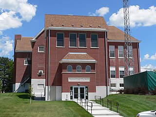
Thurston County is a county in the U.S. state of Nebraska. As of the 2020 United States Census, the population was 6,773. Its county seat is Pender.

<span class="mw-page-title-main">Sarpy County, Nebraska</span> County in Nebraska, United States

Sarpy County is a county located in the U.S. state of Nebraska. As of the 2020 census, the population was 190,604, making it the third-most populous county in Nebraska. Its county seat is Papillion.

<span class="mw-page-title-main">Douglas County, Nebraska</span> County in Nebraska, United States

Douglas County is a county located in the U.S. state of Nebraska. As of the 2020 United States Census, the population is 584,526. It is the state's most populous county, home to well over one-fourth of Nebraska's residents. Its county seat is Omaha, the state's largest city. The county was established in 1854 and named after Stephen A. Douglas (1813–1861), who was then serving as Senator from Illinois.

<span class="mw-page-title-main">Dodge County, Nebraska</span> County in Nebraska, United States

Dodge County is a county in the U.S. state of Nebraska. As of the 2020 United States Census, the population was 37,167. Its county seat is Fremont. The county was formed in 1855 and named after Iowa Senator Augustus C. Dodge.

<span class="mw-page-title-main">Dakota County, Nebraska</span> County in Nebraska, United States

Dakota County is a county in the U.S. state of Nebraska. As of the 2020 United States Census, the population was 21,582. Its county seat is Dakota City.

<span class="mw-page-title-main">Cass County, Nebraska</span> County in Nebraska, United States

Cass County is a county in the U.S. state of Nebraska. As of the 2020 United States Census, the population was 26,598. Its county seat and largest city is Plattsmouth. The county was formed in 1855, and was named for General Lewis Cass, an American military officer, politician, and statesman.

<span class="mw-page-title-main">Pottawattamie County, Iowa</span> County in Iowa, United States

Pottawattamie County is a county located in the U.S. state of Iowa. At the 2020 census, the population was 93,667, making it the tenth-most populous county in Iowa. The county takes its name from the Potawatomi Native American tribe. The county seat is Council Bluffs.

<span class="mw-page-title-main">Arnolds Park, Iowa</span> City in Iowa, United States

Arnolds Park is a city in Dickinson County, Iowa, United States. The population was 1,110 in the 2020 census, a decline from the 1,162 population in the 2000 census.

<span class="mw-page-title-main">Crescent, Iowa</span> City in Iowa, United States

Crescent is a city in Pottawattamie County, Iowa, United States. The population was 628 at the 2020 census.

<span class="mw-page-title-main">Lake View, Iowa</span> City in Iowa, United States

Lake View is a city in Sac County, Iowa, United States. The population was 1,113 in the 2020 census, a decline from the 1,278 population in 2000.

<span class="mw-page-title-main">Sergeant Bluff, Iowa</span> City in Iowa, United States

Sergeant Bluff is a city in Woodbury County, Iowa, United States. It is part of the Sioux City, IA–NE–SD Metropolitan Statistical Area. The population was 5,015 at the time of the 2020 census.

<span class="mw-page-title-main">Wisner, Nebraska</span> City in Nebraska, United States

Wisner is a city in northwestern Cuming County, Nebraska, United States. The population was 1,170 at the 2010 census.

<span class="mw-page-title-main">Fremont, Nebraska</span> City in Nebraska, United States

Fremont is a city and county seat of Dodge County in the eastern portion of the state of Nebraska in the Midwestern United States. The population was 27,141 at the 2020 census, making it the 6th most populous city in Nebraska. Fremont is the home of Midland University.

<span class="mw-page-title-main">Ralston, Nebraska</span> City in Douglas County, Nebraska, United States

Ralston is a city in Douglas County, Nebraska, United States. The population was 6,494 at the 2020 census. A suburb of Omaha, Ralston is surrounded on three sides by the city of Omaha by 84th, 72nd, and L Streets, and by Sarpy County on the south side.

<span class="mw-page-title-main">Niobrara, Nebraska</span> Village in Knox County, Nebraska, United States

Niobrara is a village in Knox County, Nebraska, United States. The population was 363 at the 2020 census.

<span class="mw-page-title-main">Bellevue, Nebraska</span> City in Sarpy County, Nebraska, United States

Bellevue is a suburban city in Sarpy County, Nebraska, United States. It is part of the Omaha–Council Bluffs metropolitan area, and had a population of 64,176 as of the 2020 census, making it the 3rd most populous city in Nebraska, behind Omaha and Lincoln, and the second largest city in the U.S. named "Bellevue," behind Bellevue, Washington.

<span class="mw-page-title-main">Papillion, Nebraska</span> City and county seat in Nebraska, United States

Papillion is a city in and the county seat of Sarpy County, Nebraska, United States. The city developed in the 1870s as a railroad town and suburb of Omaha. The city is part of the larger five-county metro area of Omaha. Papillion's population was 24,159 at the 2020 census, making it the 7th most populous city in Nebraska. Its growth since the late 20th century has reflected Omaha's.

East Omaha is a geographically designated community located in Omaha, Nebraska. Located three miles (5 km) from downtown Omaha, East Omaha is the site of Eppley Omaha International Airport, Omaha's main airport, and Carter Lake. This area was Omaha's first annexation, joining the city in 1854. Originally separated from Omaha by the Missouri River, a large section of the area's land was dissected by a ruling from the U.S. Supreme Court in 1892. Today, 2,500 houses, a school, grocery stores and a church that made up the original town have been demolished and replaced by several government facilities, the Eppley Airfield, and more.

<span class="mw-page-title-main">Creston, Iowa</span> City in Iowa, United States

Creston is a city in and the county seat of Union County, Iowa. The population was 7,536 at the time of the 2020 Census.

Abbott Drive is a roadway mostly in Omaha, Nebraska, United States, but passes briefly through Carter Lake, Iowa. It is the easternmost link in Omaha's Park and Boulevard System that connects the eastern edge of Creighton University and North Downtown Omaha or NoDo to Carter Lake, Iowa, Eppley Airfield to John J Pershing Drive on the eastern end of Florence, Nebraska. Considered "Omaha's gateway", the drive includes a distinctive "string of pearls" lighting feature.

References

  1. "2020 U.S. Gazetteer Files". United States Census Bureau. Retrieved March 16, 2022.
  2. 1 2 U.S. Geological Survey Geographic Names Information System: Carter Lake, Iowa
  3. 1 2 "2020 Census State Redistricting Data". census.gov. United states Census Bureau. Retrieved August 12, 2021.
  4. U.S. Geological Survey Geographic Names Information System: Carter Lake
  5. "Levi Carter Park". City of Omaha Parks and Recreation. Archived from the original on April 10, 2009. Retrieved December 30, 2008.
  6. "Carter Lake History". September 24, 2007. Archived from the original on September 23, 2007.
  7. "The Rise and Fall of Cut-Off Lake." June 1, 1890. Omaha Sunday Bee 19(342): 9.
  8. "Nebraska v. Iowa", 143 U.S. 359 (1892).
  9. Nebraska v. Iowa , 406 U.S. 117 (1972).
  10. 1 2 3 Harding, David (August 22, 2010). "What's the deal with Carter Lake" . Omaha World-Herald .
  11. 1 2 Schreier, John (2017). Carter Lake: A Slice of Iowa in Nebraska. Arcadia Publishing. ISBN   9781625857194.
  12. "A History of Sand Point Beach and the Lakeview Amusement Park", Fletcher Sasse, Adam. NorthOmahaHistory.com. Retrieved May 8, 2018.
  13. Transcript to "Nebraska's gambling history" Archived October 14, 2008, at the Wayback Machine , Nebraska ETV. Retrieved 11/20/08.
  14. Owen Equipment & Erection Co. v. Kroger , 437 U.S. 365 (1978).
  15. Text of Owen Equipment & Erection Co. v. Kroger, 437 U.S. 365(1978) is available from:  Findlaw    Google Scholar    Justia    Library of Congress    Oyez (oral argument audio)  
  16. Highway and Transportation Map: Pottawatomie County (PDF) (Map). Iowa Department of Transportation. January 1, 2020. Retrieved February 3, 2022.{{cite map}}: CS1 maint: date and year (link)
  17. "US Gazetteer files 2010". United States Census Bureau. Archived from the original on July 2, 2012. Retrieved May 11, 2012.
  18. "Census of Population and Housing". Census.gov. Retrieved June 4, 2015.
  19. "U.S. Census website". United States Census Bureau . Retrieved January 31, 2008.
  20. "U.S. Census website". United States Census Bureau . Retrieved May 11, 2012.
  21. Bell, Mike. "Carter Lake Elections: Cumberledge bests ex-mayor; Wahl is elected". The Daily Nonpareil - Council Bluffs, Iowa. Retrieved June 19, 2019.