La Vista, Nebraska

Last updated

La Vista, Nebraska
La Vista, NE.jpg
View south on 72nd Street just south of Harrison Street in La Vista, July 2017
Sarpy County Nebraska Incorporated and Unincorporated areas La Vista Highlighted.svg
Location of La Vista within Nebraska and Sarpy County
Coordinates: 41°10′53″N96°04′02″W / 41.18139°N 96.06722°W / 41.18139; -96.06722
Country United States
State Nebraska
County Sarpy
Area
[1]
  Total3.28 sq mi (8.50 km2)
  Land3.28 sq mi (8.49 km2)
  Water0.00 sq mi (0.01 km2)
Elevation
[2]
1,096 ft (334 m)
Population
 (2020)
  Total16,746
  Density5,105.49/sq mi (1,972.44/km2)
Time zone UTC-6 (Central (CST))
  Summer (DST) UTC-5 (CDT)
ZIP code
68128
Area code 402
FIPS code 31-26385
GNIS feature ID2395575 [2]
Website http://cityoflavista.org/

La Vista is a city in Sarpy County, Nebraska, United States. The population was 16,746 at the 2020 census, making it the 12th most populous city in Nebraska. The city was incorporated on February 23, 1960.

Contents

Description

La Vista is a suburb of Omaha. It is bordered by the cities of Omaha and Ralston on the north, Papillion on the south, Bellevue on the east, and Interstate 80 to the west. La Vista is Sarpy County's third largest city, after Bellevue and Papillion, the county seat.

History

La Vista was established in 1959 by a developer who planned to build 335 homes on La Vista’s land. Priced at a modest $9,999 each, it soon became known as "House of Nines." At the time, the assessed valuation was just over $1,000,000. The first families began moving into their homes in January 1960. La Vista (meaning "the view") was selected as its name by these "early settlers" because of the beautiful scenic view of the Big Papio Creek basin southeast of the development. [3]

Geography

According to the United States Census Bureau, the city has a total area of 3.28 square miles (8.50 km2), all land. [4]

Demographics

Historical population
CensusPop.Note
1970 4,858
1980 9,58897.4%
1990 9,8402.6%
2000 11,69918.9%
2010 15,75834.7%
2020 16,7466.3%
U.S. Decennial Census [5]

2020 census

The 2020 United States census [6] counted 16,746 people, 7,073 households, and 4,213 families in La Vista. The population density was 5,105.5 per square mile (1,972.4/km2). There were 7,314 housing units at an average density of 2,229.9 per square mile (861.5/km2). The racial makeup was 78.68% (13,176) white, 4.71% (788) black or African-American, 0.36% (61) Native American, 3.57% (598) Asian, 0.11% (19) Pacific Islander, 4.22% (706) from other races, and 8.35% (1,398) from two or more races. Hispanic or Latino of any race was 10.0% (1,858) of the population.

Of the 7,073 households, 26.0% had children under the age of 18; 44.5% were married couples living together; 29.3% had a female householder with no husband present. 29.4% of households consisted of individuals and 9.7% had someone living alone who was 65 years of age or older. The average household size was 2.4 and the average family size was 3.1.

24.0% of the population was under the age of 18, 8.8% from 18 to 24, 30.9% from 25 to 44, 24.7% from 45 to 64, and 13.6% who were 65 years of age or older. The median age was 35.3 years. For every 100 females, the population had 93.9 males. For every 100 females ages 18 and older, there were 91.1 males.

The 2016-2020 5-year American Community Survey [7] estimates show that the median household income was $70,184 (with a margin of error of +/- $4,275) and the median family income $84,777 (+/- $5,784). Males had a median income of $42,389 (+/- $3,203) versus $33,504 (+/- $3,262) for females. The median income for those above 16 years old was $38,068 (+/- $2,397). Approximately, 2.4% of families and 5.4% of the population were below the poverty line, including 5.4% of those under the age of 18 and 3.9% of those ages 65 or over.

2010 census

At the 2010 census there were 15,758 people, 6,419 households, and 4,058 families living in the city. The population density was 3,681.8 inhabitants per square mile (1,421.6/km2). There were 6,670 housing units at an average density of 1,558.4 per square mile (601.7/km2). The racial makeup of the city was 86.9% White, 3.9% African American, 0.4% Native American, 3.2% Asian, 0.1% Pacific Islander, 2.6% from other races, and 2.8% from two or more races. Hispanic or Latino of any race were 6.5%. [8]

Of the 6,419 households 34.5% had children under the age of 18 living with them, 45.7% were married couples living together, 12.9% had a female householder with no husband present, 4.6% had a male householder with no wife present, and 36.8% were non-families. 28.7% of households were one person and 5.1% were one person aged 65 or older. The average household size was 2.45 and the average family size was 3.06.

The median age was 32.1 years. 25.9% of residents were under the age of 18; 10.3% were between the ages of 18 and 24; 31.7% were from 25 to 44; 24.6% were from 45 to 64; and 7.5% were 65 or older. The gender makeup of the city was 48.3% male and 51.7% female.

2000 census

At the 2000 census, there were 11,699 people, 4,404 households, and 3,131 families living in the city. The population density was 4,114.8 inhabitants per square mile (1,588.7/km2). There were 4,511 housing units at an average density of 1,586.6 per square mile (612.6/km2). The racial makeup of the city was 90.45% White, 2.94% African American, 0.39% Native American, 2.35% Asian, 0.10% Pacific Islander, 1.62% from other races, and 2.14% from two or more races. Hispanic or Latino of any race were 4.15% of the population.

Of the 4,404 households 40.0% had children under the age of 18 living with them, 52.5% were married couples living together, 14.9% had a female householder with no husband present, and 28.9% were non-families. 21.4% of households were one person and 3.3% were one person aged 65 or older. The average household size was 2.66 and the average family size was 3.13.

The age distribution was 29.8% under the age of 18, 10.4% from 18 to 24, 36.4% from 25 to 44, 18.9% from 45 to 64, and 4.5% 65 or older. The median age was 30 years. For every 100 females, there were 94.6 males. For every 100 females age 18 and over, there were 89.6 males.

The median household income was $47,280, and the median family income was $52,819. Males had a median income of $34,732 versus $25,076 for females. The per capita income for the city was $19,612. About 4.4% of families and 5.7% of the population were below the poverty line, including 7.9% of those under age 18 and 3.1% of those age 65 or over.

Schools

Almost all of La Vista falls within the Papillion-La Vista Public School system, while a small section is in Millard Public Schools. [9]

Elementary schools

(Grades K-6)

Middle school

Grades 7-8 La Vista Junior High is located at 7900 Edgewood Blvd

High schools

Grades 9-12

Transportation

Transit service to the city is provided by Metro Transit. Route 93 serves the city on weekdays. [10]

See also

Related Research Articles

<span class="mw-page-title-main">Sarpy County, Nebraska</span> County in Nebraska, United States

Sarpy County is a county located in the U.S. state of Nebraska. As of the 2020 census, the population was 190,604, making it the third-most populous county in Nebraska. Its county seat is Papillion.

<span class="mw-page-title-main">Douglas County, Nebraska</span> County in Nebraska, United States

Douglas County is a county located in the U.S. state of Nebraska. As of the 2020 United States Census, the population is 584,526. It is the state's most populous county, home to well over one-fourth of Nebraska's residents. Its county seat is Omaha, the state's largest city. The county was established in 1854 and named after Stephen A. Douglas (1813–1861), who was then serving as Senator from Illinois.

<span class="mw-page-title-main">Cass County, Nebraska</span> County in Nebraska, United States

Cass County is a county in the U.S. state of Nebraska. As of the 2020 United States Census, the population was 26,598. Its county seat and largest city is Plattsmouth. The county was formed in 1855, and was named for General Lewis Cass, an American military officer, politician, and statesman.

<span class="mw-page-title-main">Mohawk Vista, California</span> Census-designated place in California, United States

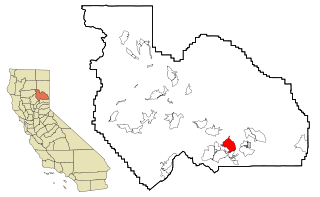
Mohawk Vista is a census-designated place in Plumas County, California, United States. The population was 159 at the 2010 census, up from 121 at the 2000 census.

<span class="mw-page-title-main">Alta Vista, Kansas</span> City in Wabaunsee County, Kansas

Alta Vista is a city in Wabaunsee County, Kansas, United States. As of the 2020 census, the population of the city was 409.

<span class="mw-page-title-main">Decatur, Nebraska</span> Village in Nebraska, United States

Decatur is a village in Burt County, Nebraska, United States, adjacent to the upper Missouri River. The population was 481 at the 2010 census. This town is named after one of its incorporators, Stephen Decatur. It developed around a trading post established by Colonel Peter Sarpy, the namesake for Sarpy County in the state.

<span class="mw-page-title-main">Louisville, Nebraska</span> City in Nebraska, United States

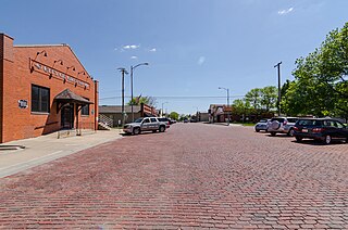
Louisville is a city in northern Cass County, Nebraska, United States. The population was 1,319 at the 2020 census.

<span class="mw-page-title-main">Ralston, Nebraska</span> City in Douglas County, Nebraska, United States

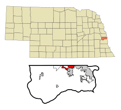
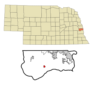
Ralston is a city in Douglas County, Nebraska, United States. The population was 6,494 at the 2020 census. A suburb of Omaha, Ralston is surrounded on three sides by the city of Omaha by 84th, 72nd, and L Streets, and by Sarpy County on the south side.

<span class="mw-page-title-main">Burwell, Nebraska</span> City in Nebraska, United States

Burwell is a city in Garfield County, Nebraska, United States. The population was 1,210 at the 2010 census. It is the county seat of Garfield County.

<span class="mw-page-title-main">Ogallala, Nebraska</span> City in Nebraska, United States

Ogallala is a city in and the county seat of Keith County, Nebraska, United States. The population was 4,878 at the 2020 census, up from 4,737 at the 2010 census. In the days of the Nebraska Territory, the city was a stop on the Pony Express and later along the transcontinental railroad. The Ogallala Formation that carries the Ogallala Aquifer was named after the city.

<span class="mw-page-title-main">Crete, Nebraska</span> City in Saline County, Nebraska, United States

Crete is a city in and the most populous municipality of Saline County, Nebraska, United States. The population was 7,099 at the 2020 census. The city is home to Doane University.

<span class="mw-page-title-main">Bellevue, Nebraska</span> City in Sarpy County, Nebraska, United States

Bellevue is a suburban city in Sarpy County, Nebraska, United States. It is part of the Omaha–Council Bluffs metropolitan area, and had a population of 64,176 as of the 2020 census, making it the 3rd most populous city in Nebraska, behind Omaha and Lincoln, and the second largest city in the U.S. named "Bellevue," behind Bellevue, Washington.

<span class="mw-page-title-main">Chalco, Nebraska</span> CDP in Nebraska, United States

Chalco is a census-designated place (CDP) in northern Sarpy County, Nebraska, United States, and an adjacent suburb of Omaha, with La Vista located to the southeast. The population was 11,064 at the 2020 census.

<span class="mw-page-title-main">Gretna, Nebraska</span> City in Sarpy County, Nebraska, United States

Gretna is a city in Sarpy County, Nebraska, United States. The population was 5,083 at the 2020 census.

<span class="mw-page-title-main">Papillion, Nebraska</span> City and county seat in Nebraska, United States

Papillion is a city in and the county seat of Sarpy County, Nebraska, United States. The city developed in the 1870s as a railroad town and suburb of Omaha. The city is part of the larger five-county metro area of Omaha. Papillion's population was 24,159 at the 2020 census, making it the 7th most populous city in Nebraska. Its growth since the late 20th century has reflected Omaha's.

<span class="mw-page-title-main">Springfield, Nebraska</span> City in Sarpy County, Nebraska, United States

Springfield is a city in Sarpy County, Nebraska, United States. The population was 1,501 at the 2020 census.

<span class="mw-page-title-main">Seward, Nebraska</span> City in and county seat of Seward County, Nebraska, United States

Seward is a city and county seat of Seward County, Nebraska, United States. The population was 6,964 at the 2010 census. Seward is part of the Lincoln, Nebraska Metropolitan Statistical Area.

<span class="mw-page-title-main">Stanton, Nebraska</span> Village in and county seat of Stanton County, Nebraska, United States

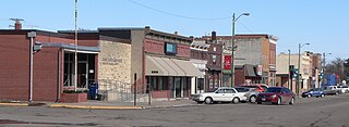
Stanton is a city in Stanton County, Nebraska, United States. The population was 1,577 at the 2010 census. It is the county seat of Stanton County. Stanton was platted in 1870. Both the city and county are named after Edwin Stanton, secretary of war for president Abraham Lincoln during the American Civil War.

<span class="mw-page-title-main">Fort Calhoun, Nebraska</span> City in Washington County, Nebraska, United States

Fort Calhoun is a city in Washington County, Nebraska, United States. The population was 1,108 at the 2020 census. The city includes Fort Atkinson, the first fort built west of the Missouri River.

<span class="mw-page-title-main">York, Nebraska</span> City in and county seat of York County, Nebraska, United States

York is a city in and the county seat of York County, Nebraska, United States. At the 2010 census, the city population was 7,766. It is the home of York University and the Nebraska Correctional Center for Women.

References

  1. "ArcGIS REST Services Directory". United States Census Bureau. Retrieved September 18, 2022.
  2. 1 2 U.S. Geological Survey Geographic Names Information System: La Vista, Nebraska
  3. "La Vista, Sarpy County". Center for Advanced Land Management Information Technologies. University of Nebraska. Retrieved August 23, 2014.
  4. "US Gazetteer files 2010". United States Census Bureau. Archived from the original on January 25, 2012. Retrieved June 24, 2012.
  5. United States Census Bureau. "Census of Population and Housing" . Retrieved June 19, 2013.
  6. "Explore Census Data". data.census.gov. Retrieved December 18, 2023.
  7. "Explore Census Data". data.census.gov. Retrieved December 18, 2023.
  8. "U.S. Census website". United States Census Bureau . Retrieved June 24, 2012.
  9. "2020 CENSUS - SCHOOL DISTRICT REFERENCE MAP: Sarpy County, NE" (PDF). U.S. Census Bureau . Retrieved October 3, 2022.
  10. "Metro Map" . Retrieved July 21, 2023.