Berkeley Plantation, one of the first plantations in America, comprises about 1,000 acres (400 ha) on the banks of the James River on State Route 5 in Charles City County, Virginia. Berkeley Plantation was originally called Berkeley Hundred, named after the Berkeley Company of England. In 1726, it became the home of the Harrison family of Virginia, after Benjamin Harrison IV located there and built one of the first three-story brick mansions in Virginia. It is the ancestral home of two presidents of the United States: William Henry Harrison, who was born there in 1773 and his grandson Benjamin Harrison. It is now a museum property, open to the public.

West Point is an incorporated town in King William County, Virginia, United States. The population was 3,414 at the 2020 census.

Cape Charles is a town / municipal corporation in Northampton County, Virginia, United States. The population was 1,009 as of the 2010 Census.

Montross is a town in Westmoreland County, Virginia, United States. The population was 553 at the 2020 census. It is the county seat of Westmoreland County. Located in the historic Northern Neck of Virginia, Montross is near the George Washington Birthplace National Monument and the Stratford Hall Plantation. The town's slogan is return to the village.

The James River is a river in Virginia that begins in the Appalachian Mountains and flows from the confluence of the Cowpasture and Jackson Rivers in Botetourt County 348 miles (560 km) to the Chesapeake Bay. The river length extends to 444 miles (715 km) if the Jackson River is included, the longer of its two headwaters. It is the longest river in Virginia. Jamestown and Williamsburg, Virginia's first colonial capitals, and Richmond, Virginia's current capital, lie on the James River.

The Patuxent River is a tributary of the Chesapeake Bay in the state of Maryland. There are three main river drainages for central Maryland: the Potomac River to the west passing through Washington, D.C., the Patapsco River to the northeast passing through Baltimore, and the Patuxent River between the two. The 908-square-mile (2,352 km2) Patuxent watershed had a rapidly growing population of 590,769 in 2000. It is the largest and longest river entirely within Maryland, and its watershed is the largest completely within the state.

First Landing State Park offers recreational opportunities at Cape Henry in the independent city of Virginia Beach, Virginia. As the first planned state park of Virginia, First Landing is listed on the National Register of Historic Places as Seashore State Park Historic District. A portion of the park is listed as a National Natural Landmark as part of the Seashore Natural Area.

Croaker is an unincorporated community in James City County, Virginia, United States on the south bank of the York River 10 miles downstream from West Point. The York River is formed from the confluence of the Mattaponi River and the Pamunkey River at West Point. The York River empties into the Chesapeake Bay about 30 miles downstream from Croaker.
Varina Farms, also known as Varina Plantation or Varina Farms Plantation or Varina on the James, is a plantation established in the 17th century on the James River about 10 miles (16 km) south of Richmond, Virginia. An 820-acre (330 ha) property was listed on the National Register of Historic Places in 1977 as "Varina Plantation". At that time it included two contributing buildings and one other contributing site.

Chippokes State Park is a Virginia state park on the south side of the James River on the Captain John Smith Chesapeake National Historic Trail. In addition to forests and fossil hunting on the beach, it includes three historic houses as well as an open-air agricultural and forestry museum with seasonally appropriate events. Other recreational facilities include a visitor center, swimming pool, hiking trails, cabins, yurts and campgrounds). It is located at 695 Chippokes Park Road, in rural Surry County, Virginia off Route 10.

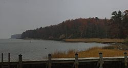
Werowocomoco was a village that served as the headquarters of Chief Powhatan, a Virginia Algonquian political and spiritual leader when the English founded Jamestown in 1607. The name Werowocomoco comes from the Powhatan werowans (weroance), meaning "leader" in English; and komakah (-comoco), "settlement". The town was documented by English settlers in 1608 as located near the north bank of the York River in what is now Gloucester County. It was separated by that river and the narrow Virginia Peninsula from the English settlement of Jamestown, located on the James River.

The Albemarle and Chesapeake Canal was built by a corporation in 1856-1860 to afford inland navigation between the Chesapeake Bay and the Albemarle Sound. It is really two canals, thirty miles (50 km) apart, one eight and one-half miles (13.7 km) long, connecting the Elizabeth River with the North Landing River in Virginia, and the other five and one-half miles (8.9 km) long, connecting the Currituck Sound with the North River in North Carolina.

America's 11 Most Endangered Places or America's 11 Most Endangered Historic Places is a list of places in the United States that the National Trust for Historic Preservation considers the most endangered. It aims to inspire Americans to preserve examples of architectural and cultural heritage that could be "relegated to the dustbins of history" without intervention.

Morattico is an unincorporated former post office town along the Rappahannock River in Lancaster County, Virginia, United States. It sits across Mulberry Creek from Belle Isle State Park. "Morattico" is an anglicized version of "Moraughtacund", the name of a Native American tribe whose primary village may have been on or near this site.

Flowerdew Hundred Plantation dates to 1618/19 with the patent by Sir George Yeardley, the Governor and Captain General of Virginia, of 1,000 acres (400 ha) on the south side of the James River. Yeardley probably named the plantation after his wife's wealthy father, Anthony Flowerdew, just as he named another plantation "Stanley Hundred" after his wife's wealthy mother, Martha Stanley. A "hundred" was historically a division of a shire or county. With a population of about 30, the plantation was economically successful with thousands of pounds of tobacco produced along with corn, fish and livestock. Sir George paid 120 pounds to build the first windmill in British America.
Fort Howard is an unincorporated community and census-designated place in Baltimore County, Maryland, United States. The population was 303 at the 2010 census. The median age is 47.9. 52.86% are female and 47.14% are male. 58.9% are married and 41.1% are single. The average household size is 2.64.

Staunton River State Park is a state park in Virginia. One of the Commonwealth's original state parks, built by the Civilian Conservation Corps and opening in 1936, it is located along the Staunton River near Scottsburg, Virginia. It is an International Dark Sky Park.

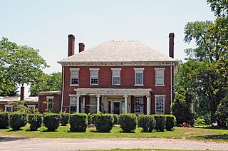
Mount Clare, also known as Mount Clare Mansion and generally known today as the Mount Clare Museum House, is the oldest Colonial-era structure in the City of Baltimore, Maryland, U.S.A. The Georgian style of architecture plantation house exhibits a somewhat altered five-part plan. It was built on a Carroll family plantation beginning in 1763 by barrister Charles Carroll the Barrister, (1723–1783), a descendant of the last Gaelic Lords of Éile in Ireland and a distant relative of the much better-known Charles Carroll of Carrollton, (1737–1832), longest living signer of the Declaration of Independence and the richest man in America in his later years, also the layer of the First Stone of the new Baltimore and Ohio Railroad, just a short distance away in 1828.
St. Inigoes, sometimes called St. Inigoes Shores, is a small, rural, unincorporated farming, fishing and crabbing community at the southern end of St. Mary's County in the U.S. state of Maryland that is undergoing a transition to small residential subdevelopment plots. Its western side is bordered by a number of coves and creeks that are connected to the St. Marys River, a brackish tidal tributary, near where it feeds into the mouth of the Potomac River and close to its entry point into the Chesapeake Bay.

Windsor Shades is located on the Pamunkey River in Sweet Hall, Virginia, United States. It is listed on the National Register of Historic Places. Archeological native artifacts found on the property surrounding the house suggest it was the site of Kupkipcok, a Pamunkey village noted on John Smith's 1609 map.