Zakatal okrug

Last updated
Zakatal okrug
Закатальский округ
Coat of Arms of Zakataly (1843).gif
Zakataly Okrug of Caucasus Viceroyalty.png
Location in the Caucasus Viceroyalty
Country Russian Empire
Viceroyalty Caucasus
Established1859
Abolished1918
CapitalZakataly
(present-day Zaqatala)
Area
  Total3,985.77 km2 (1,538.91 sq mi)
Population
 (1916)
  Total92,608
  Density23/km2 (60/sq mi)
   Urban
4.86%
   Rural
95.14%

The Zakatal okrug [lower-alpha 1] was a special administrative district ( okrug ) of the Caucasus Viceroyalty of the Russian Empire, part of the Tiflis Governorate from 1893 to 1905. The administrative centre of the district was Zakataly (present-day Zaqatala), and it corresponded to most of the contemporary districts of Balakan, Zaqatala and Qax of Azerbaijan. The Zakatal okrug was established from the territories of the erstwhile Free Jamaats of Jar-Balakan, bordering the Tiflis Governorate to the west, the Elizavetpol Governorate to the south and the Dagestan Oblast to the north. The district was the smallest independent (not part of any province or region) administrative unit of the Russian Empire, similarly to the Sukhumi okrug.

Contents

History

The district was originally established under the name Belokan in 1842, within the Georgia-Imeretia Governorate, two years after it was renamed to Jaro-Belokan. The autonomous status of the district was confirmed in 1846, leading to its renaming to Zakataly in 1860 and its placement into the temporary administration of Dagestan during which its administration was organised into a military council, of which the chief was the head of the district, concurrently with Dagestan. [1] In 1881, an independent administration was introduced. The Zakatal okrug was incorporated into the 'civilian' administration of the Tiflis Governorate from 1893 until 1905 when was removed and placed directly under the Viceroy of the Caucasus. [2]

The social structure of the Zakatal okrug was multi-layered in its patriarchal-clans which were involved in "mountain feudalism", which became muddled by growing ethno-nationalism and the social differences they bore. The Free Jamaats (Society) peoples were the collective owners of the lands in which the Ingiloys and Tatars (later Azerbaijanis) lived, for which the latter paid tax to them. In 1863, a rumor circulated that the administration of Zakataly was planning to emancipate the Georgians and Tatars from their financial obligations to the Free Jamaats peoples, leading to an anti-Russian uprising of its Dagestani inhabitants. The uprising became elevated by the declaration of jihad (holy war) until its suppression by local troops assisted by Tatar volunteers. [3]

Following the Russian Revolution, most of the district was incorporated into the Azerbaijan Democratic Republic [1] [4] [5] [6] and transformed into the Zaqatala Governorate, despite also being claimed by the neighboring Democratic Republic of Georgia. On account of the dispute, the authorities of both states agreed to resolve the territorial dispute over Zakatal strictly by peaceful means. [5] A few hundred Armenians remained in the district by 1919 and were harassed by outlaws. [7]

Despite the Russian SFSR initially recognising the Zakatal okrug as part of Georgia in the Treaty of Moscow, [8] [9] a mixed commission consisting of Georgians and Azerbaijanis was formed to arbitrate the dispute following the region's sovietisation. [10] During the administrative-territorial reforms of the 1920s, the Zakataly district was separated into the raions of Balakan, Zagatala, and Gakh.

Economy

The main occupations of the predominantly Sunni population included cattle breeding, agriculture, viticulture, picking fruits (mainly walnuts), handicrafts and silkworm breeding. [3]

Administrative divisions

The prefectures (участки, uchastki ) of the Zakatal okrug were: [11] [12]

NameAdministrative centre1912 populationArea
Aliabadskiy prefecture (Алиабадский участок) Aliabad 14,254430.45 square versts (489.88  km2 ; 189.14  sq mi )
Dzharo-Mukhakhskiy prefecture (Джаро-Мухахский участок)Zakataly (Zaqatala)38,8791,737.01 square versts (1,976.83  km2 ; 763.26  sq mi )
Kakhskiy prefecture (Кахский участок)Kakh (Qax)17,5951,334.78 square versts (1,519.06  km2 ; 586.51  sq mi )
Almalinskiy rayon (Алмалинский район)Almalo (Almalı)
Belokanskiy rayon (Белоканский район)Belokany (Balakən)
Mukhakhskiy rayon (Мухахский район)Mukhakh (Muxax)

There once existed a Gornye magaly (lit.'mountain quarters') district "along the headwaters of the Samur", however, it was dissolved in 1860. [13] There was also a Belokanskiy prefecture (Белоканский участок) prior to 1912. [14]

Demographics

Russian Empire Census

According to the Russian Empire Census, the Zakatal okrug—then part of the Tiflis Governorate—had a population of 84,224 on 28 January [ O.S. 15 January] 1897, including 45,418 men and 38,806 women. The plurality of the population indicated Avar-Andean to be their mother tongue, with significant Tatar, [lower-alpha 2] Georgian, and Dargin speaking minorities. [17]

Linguistic composition of the Zakatal okrug in 1897 [17]
LanguageNative speakers%
Avar-Andean 31,67037.60
Tatar [lower-alpha 2] 28,95034.37
Georgian 12,38914.71
Dargin 7,4418.83
Armenian 2,1002.49
Kyurin 9751.16
Russian 3150.37
Ukrainian 1180.14
Polish 1150.14
Kazi-Kumukh 610.07
German 110.01
Jewish 110.01
Persian 70.01
Ossetian 60.01
Mingrelian 30.00
Turkish 30.00
Greek 20.00
Imeretian 20.00
Belarusian 10.00
Kist 10.00
Other430.05
TOTAL84,224100.00

Kavkazskiy kalendar

According to the 1917 publication of Kavkazskiy kalendar , the Zakatal okrug had a population of 92,608 on 14 January [ O.S. 1 January] 1916, including 48,323 men and 44,285 women, 86,128 of whom were the permanent population, and 6,480 were temporary residents: [18]

Nationality Urban Rural TOTAL
Number%Number%Number%
Sunni Muslims [lower-alpha 3] 2886.3942,49148.2342,77946.19
North Caucasians 1,06823.7140,71246.2141,78045.11
Georgians 2044.534,3704.964,5744.94
Armenians 2,16548.063650.412,5302.73
Shia Muslims [lower-alpha 4] 48610.79910.105770.62
Russians 2705.99560.063260.35
Other Europeans 210.4720.00230.02
Asiatic Christians 00.00160.02160.02
Jews 30.0700.0030.00
TOTAL4,505100.0088,103100.0092,608100.00

Notes

  1. 1 2 Before 1918, Azerbaijanis were generally known as "Tatars". This term, employed by the Russians, referred to Turkic-speaking Muslims of the South Caucasus. After 1918, with the establishment of the Azerbaijan Democratic Republic and "especially during the Soviet era", the Tatar group identified itself as "Azerbaijani". [15] [16]
  2. Primarily Turco-Tatars. [19]
  3. Primarily Tatars. [19]

Related Research Articles

Dagestan <i>Oblast</i> Province of the Russian Empire from 1860 to 1917

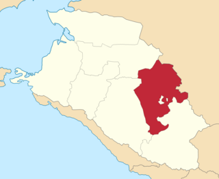
The Dagestan Oblast was a province (oblast) of the Caucasus Viceroyalty of the Russian Empire. It roughly corresponded to most of present-day southeastern Dagestan within the Russian Federation. The Dagestan oblast was created in 1860 out of the territories of the former Caucasian Imamate, bordering the Terek Oblast to the north, the Tiflis Governorate and Zakatal Okrug to the west, the Elizavetpol Governorate to the south, and Baku Governorate to the east. The administrative center of the oblast was Temir-Khan-Shura.

Sukhumi <i>okrug</i> Okrug in Caucasus, Russian Empire

The Sukhumi or Sukhum okrug was a special administrative district (okrug) in the Caucasus Viceroyalty of the Russian Empire, part of the Kutaisi Governorate from 1883 until 1905. The administrative center of the district was the Black Sea port city of Sukhum. The okrug bordered the Kutaisi Governorate to the southwest, the Kuban Oblast to the north and the Black Sea Governorate to the northwest and in terms of its area corresponded to most of contemporary Abkhazia. During 1905–1917, the Sukhumi okrug was one of the smallest independent administrative units of the Russian Empire, second to the Zakatal okrug.

Zugdidi <i>uezd</i> Uezd in Caucasus, Russian Empire

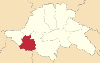
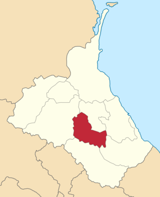
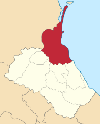
The Zugdidi uezd was a county (uezd) of the Kutaisi Governorate of the Caucasus Viceroyalty of the Russian Empire. It bordered the Sukhumi Okrug to the north, the Lechkhumi uezd to the east, the Senaki uezd to the south, and the Black Sea to the west. The area of the Zugdidi uezd corresponded to most of the contemporary Samegrelo-Zemo Svaneti region of Georgia. The county was eponymously named for its administrative center, Zugdidi.

Akhalkalaki <i>uezd</i> Uezd in Caucasus, Russian Empire

The Akhalkalaki uezd was a county (uezd) of the Tiflis Governorate of the Caucasus Viceroyalty of the Russian Empire, and then of Democratic Republic of Georgia, with its administrative centre in Akhalkalak. The county bordered the Gori uezd to the north, the Borchaly uezd to the east, the Alexandropol uezd of the Erivan Governorate and the Kars and Ardahan okrugs of the Kars Oblast to the south, and the Akhaltsikhe uezd to the west. The area of the county roughly corresponded to the contemporary Samtskhe–Javakheti region of Georgia.

Akhaltsikhe <i>uezd</i> Uezd in Caucasus, Russian Empire

The Akhaltsikhe uezd was a county (uezd) of the Tiflis Governorate of the Caucasus Viceroyalty of the Russian Empire, and then of Democratic Republic of Georgia, with its administrative center in Akhaltsikh. The uezd bordered the Gori uezd and the Kutaisi Governorate to the north, the Akhalkalaki uezd to the east, the Ardahan Okrug of the Kars Oblast to the south, and the Batum Okrug of the Batum Oblast to the west. The area of the uezd roughly corresponded to the contemporary Samtskhe-Javakheti region of Georgia.

Dusheti <i>uezd</i> Uezd in Caucasus, Russian Empire

The Dusheti uezd was a county (uezd) of the Tiflis Governorate of the Caucasus Viceroyalty of the Russian Empire, and then of Democratic Republic of Georgia, with its administrative centre in Dushet. The area of the uezd roughly corresponded to the contemporary Mtskheta-Mtianeti region of Georgia.

Telavi <i>uezd</i> Uezd in Caucasus, Russian Empire

The Telavi uezd was a county (uezd) of the Tiflis Governorate of the Caucasus Viceroyalty of the Russian Empire, and then of Democratic Republic of Georgia, with its administrative center in Telavi. The area of the county roughly corresponded to the contemporary Samtskhe-Javakheti region of Georgia.

Tiflis <i>uezd</i> Uezd in Caucasus, Russian Empire

The Tiflis uezd was a county (uezd) of the Tiflis Governorate of the Caucasus Viceroyalty of the Russian Empire, and then of Democratic Republic of Georgia, with its administrative centre in Tiflis. The area of the uezd roughly corresponded to the contemporary Kvemo Kartli region of Georgia. The district bordered the Telavi uezd to the northeast, the Tionety and Dusheti uezds to the north, the Gori uezd to the northwest, the Borchaly uezd to the west, the Kazakh uezd of the Elizavetpol Governorate to the south, and the Signakh uezd to the east.

Artvin <i>okrug</i> Okrug in Caucasus, Russian Empire

The Artvin okrug was a district (okrug) of the Batum Oblast of the Russian Empire, existing between 1878 and 1918. The district was eponymously named for its administrative centre, Artvin, presently part of the Artvin Province of Turkey. The district bordered with the Olti okrug to the south, the Ardahan okrug to the east, the Batumi okrug to the north, and the Ottoman Empire to the west. Between 1883 and 1903, the Artvin okrug formed a part of the Kutaisi Governorate.

Batumi <i>okrug</i> Okrug in Caucasus, Russian Empire

The Batumi okrug was a district (okrug) of the Batum Oblast of the Russian Empire existing between 1878 and 1918. The district was eponymously named for its administrative center, the town of Batum, now part of Adjara within Georgia. The okrug bordered with the Artvin okrug in the south, the Ardahan okrug of the Kars Oblast to the southeast, the Tiflis Governorate to the northeast, the Kutaisi Governorate to the north, and the Trebizond Vilayet of the Ottoman Empire to the west.

Kutaisi <i>uezd</i> Uezd in Caucasus, Russian Empire

The Kutaisi uezd was a county (uezd) of the Kutaisi Governorate of the Caucasus Viceroyalty of the Russian Empire. It bordered the Akhaltsikhe uezd of the Tiflis Governorate to the south, the Ozurgeti and Senaki uezds to the west, the Lechkhumi and Racha uezds to the north, and the Shorapani uezd to the east. The area of the uezd corresponded to most of the contemporary Imereti region of Georgia. The Kutaisi uezd was eponymously named for its administrative center, Kutais.

Senaki <i>uezd</i> Uezd in Caucasus, Russian Empire

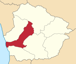
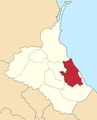
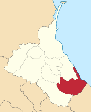
The Senaki uezd was a county (uezd) of the Kutaisi Governorate of the Caucasus Viceroyalty of the Russian Empire. It bordered the Zugdidi uezd to the west, the Lechkhumi uezd to the north, the Kutaisi uezd to the east, and the Ozurgeti uezd to the south. The area of the uezd corresponded to most of the contemporary Samegrelo-Zemo Svaneti region of Georgia. The Senaki uezd was eponymously named for its administrative center, Senaki.

Labinsky <i>otdel</i> Otdel in Caucasus, Russian Empire

The Labinsky otdel was a Cossack district of the Kuban oblast of the Caucasus Viceroyalty of the Russian Empire. It bordered the Kavkazsky otdel to the north, the Maykopsky otdel to the west, the Batalpashinsky otdel to the south, and the Stavropol Governorate to the east. The area of the Labinsky otdel mostly corresponded to the contemporary Krasnodar Krai region of the Russian Federation. The administrative capital of the district was the city of Armavir.

<i>Avarskiy okrug</i> Okrug in Caucasus, Russian Empire

The Avarskiy okrug was a district (okrug) of the Dagestan Oblast of the Caucasus Viceroyalty of the Russian Empire. The area of the Avarskiy okrug is included in contemporary Dagestan of the Russian Federation. The district's administrative centre was Khunzakh.

<i>Andiyskiy okrug</i> Okrug in Caucasus, Russian Empire

The Andiyskiy okrug was a district (okrug) of the Dagestan Oblast of the Caucasus Viceroyalty of the Russian Empire. The area of the Andiyskiy okrug is included in contemporary Dagestan of the Russian Federation. The district's administrative centre was Botlikh.

<i>Kazikumukhskiy okrug</i> Okrug in Caucasus, Russian Empire

The Kazikumukhskiy okrug was a district (okrug) of the Dagestan Oblast of the Caucasus Viceroyalty of the Russian Empire. The area of the Kazikumukhskiy okrug is included in contemporary Dagestan of the Russian Federation. The district's administrative centre was Kumukh.

<i>Kaytago-Tabasaranskiy okrug</i> Okrug in Caucasus, Russian Empire

The Kaytago-Tabasaranskiy okrug was a district (okrug) of the Dagestan Oblast of the Caucasus Viceroyalty of the Russian Empire. The area of the Kaytago-Tabasaranskiy okrug is included in contemporary Dagestan of the Russian Federation. The district's administrative centre was Madzhalis.

<i>Kyurinskiy okrug</i> Okrug in Caucasus, Russian Empire

The Kyurinskiy okrug was a district (okrug) of the Dagestan Oblast of the Caucasus Viceroyalty of the Russian Empire. The area of the Kyurinskiy okrug is included in contemporary Dagestan of the Russian Federation. The district's administrative centre was Kasumkent.

<i>Temir-Khan-Shurinskiy okrug</i> Okrug in Caucasus, Russian Empire

The Temir-Khan-Shurinskiy okrug was a district (okrug) of the Dagestan Oblast of the Caucasus Viceroyalty of the Russian Empire. The area of the Temir-Khan-Shurinskiy okrug is included in contemporary Dagestan of the Russian Federation. The district's administrative centre was Temir-Khan-Shura.

<i>Vedensky okrug</i> Okrug in Caucasus, Russian Empire

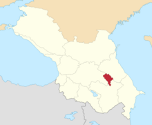
The Vedensky okrug was a district (okrug) of the Terek Oblast of the Caucasus Viceroyalty of the Russian Empire. The area of the Vedensky okrug made up part of the North Caucasian Federal District of Russia. The district was eponymously named for its administrative centre, Vedeno.

References

  1. 1 2 Janeliże 2018, pp. 52–53.
  2. Tsutsiev 2014, pp. 172–174.
  3. 1 2 "ЗАКАТАЛЬСКИЙ ОКРУГ • Большая российская энциклопедия - электронная версия". bigenc.ru. Retrieved 2021-12-16.
  4. Daushvili 2012, p. 41.
  5. 1 2 Yilmaz 2009.
  6. Javakhishvili 2011, p. 235.
  7. Hovannisian 1982, pp. 186–187.
  8. Wright, Goldenberg & Schofield 1996, p. 136.
  9. Hovannisian 1996a, p. 205.
  10. Kazemzadeh 1951, p. 299.
  11. Кавказский календарь на 1917 год, pp. 134–136.
  12. Кавказский календарь на 1913 год, pp. 156–159.
  13. Tsutsiev 2014.
  14. Кавказский календарь на 1910 год, p. 202.
  15. Bournoutian 2018, p. 35 (note 25).
  16. Tsutsiev 2014, p. 50.
  17. 1 2 "Демоскоп Weekly - Приложение. Справочник статистических показателей". Demoscope.ru. Retrieved 2013-10-05.
  18. Кавказский календарь на 1917 год, pp. 357–358.
  19. 1 2 Hovannisian 1971, p. 67.

Bibliography

41°38′01″N46°38′36″E / 41.63361°N 46.64333°E / 41.63361; 46.64333