The geography of Egypt relates to two regions: North Africa and West Asia.

Ghana is a West African country in Africa, along the Gulf of Guinea.

The Indus is a transboundary river of Asia and a trans-Himalayan river of South and Central Asia. The 3,120 km (1,940 mi) river rises in mountain springs northeast of Mount Kailash in Western Tibet, flows northwest through the disputed region of Kashmir, bends sharply to the left after the Nanga Parbat massif, and flows south-by-southwest through Pakistan, before emptying into the Arabian Sea near the port city of Karachi.

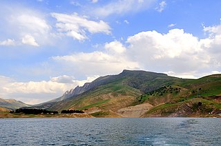
Lake Urmia is an endorheic salt lake in Iran. The lake is located between the provinces of East Azerbaijan and West Azerbaijan in Iran, and west of the southern portion of the Caspian Sea. At its greatest extent, it was the largest lake in the Middle East and the sixth-largest saltwater lake on Earth, with a surface area of approximately 5,200 km2 (2,000 sq mi), a length of 140 km (87 mi), a width of 55 km (34 mi), and a maximum depth of 16 m (52 ft).

The Litani River, the classical Leontes, is an important water resource in southern Lebanon. The river rises in the fertile Beqaa Valley, west of Baalbek, and empties into the Mediterranean Sea north of Tyre. Exceeding 140 km in length, the Litani is the longest river in Lebanon and provides an average annual flow estimated at 920 million cubic meters. The waters of the Litani both originate and flow entirely within the borders of Lebanon. It provides a major source for water supply, irrigation and hydroelectricity both within Southern Lebanon, and the country as a whole.

Lake Hāmūn, or the Hamoun Oasis, is a seasonal lake and wetlands in the endorheic Sīstān Basin in the Sistan region on the Afghanistan–Iran border. In Iran, it is also known as Hāmūn-e Helmand, Hāmūn-e Hīrmand, or Daryācheh-ye Sīstān.

Periyar, IPA:[peɾijɐːr], is the longest river and the river with the largest discharge potential in the Indian state of Kerala. It is one of the few perennial rivers in the region and provides drinking water for several major towns. The Periyar is of utmost significance to the economy of Kerala. It generates a significant proportion of Kerala's electrical power via the Idukki Dam and flows along a region of industrial and commercial activity. The river also provides water for irrigation and domestic use throughout its course besides supporting a rich fishery. Due to these reasons, the river has been named the "Lifeline of Kerala". Kochi city, in the vicinity of the river mouth, draws its water supply from Aluva, an upstream site sufficiently free of seawater intrusion. Twenty five percent of Kerala's industries are along the banks of the Periyar. These are mostly crowded within a stretch of 5 kilometres (3 mi) in the Eloor-Edayar region (Udhyogamandal), about 10 kilometres (6 mi) north of Kochi harbor.

The Colorado–Big Thompson Project is a federal water diversion project in Colorado designed to collect West Slope mountain water from the headwaters of the Colorado River and divert it to Colorado's Front Range and plains. In Colorado, approximately 80% of the state's precipitation falls on the West Slope, in the Rocky Mountains, while around 80% of the state's growing population lives along the eastern slope, between the cities of Fort Collins and Pueblo.
The Little Zab or Lower Zab is a river that originates in Iran and joins the Tigris just south of Al Zab in the Kurdistan region of Iraq. The Little Zab is approximately 400 kilometres (250 mi) long and drains an area of about 22,000 square kilometres (8,500 sq mi). The river is fed by rainfall and snowmelt, resulting in a peak discharge in the spring and low water in the summer and early fall. Two dams built on the Little Zab regulate the river flow, providing water for irrigation and generating hydroelectricity. The Zagros Mountains have been populated since at least the Lower Palaeolithic, but the earliest archaeological site in the Little Zab basin, Barda Balka, dates to the Middle Palaeolithic. Human occupation of the Little Zab basin has been attested for every period since then.

The Bear River is a tributary of the Feather River in the Sierra Nevada, winding through four California counties: Yuba, Sutter, Placer, and Nevada. About 73 miles (117 km) long, the river flows generally southwest through the Sierra then west through the Central Valley, draining a narrow, rugged watershed of 295 square miles (760 km2).
The 1930 Salmas earthquake occurred on in West Azerbaijan Province, Iran. The earthquake, which was among Iran's largest, measured 7.1 on the moment magnitude scale and had a maximum Mercalli intensity of IX (Violent). A damaging foreshock occurred fifteen hours prior to the main event and served as a warning to the people that felt it strongly. Reports from seismologists and seismological organizations indicate that up to 3,000 fatalities may have occurred in northwest Iran and southeast Turkey.

An endorheic lake is a collection of water within an endorheic basin, or sink, with no evident outlet. Endorheic lakes are generally saline as a result of being unable to get rid of solutes left in the lake by evaporation. These lakes can be used as indicators of anthropogenic change, such as irrigation or climate change, in the areas surrounding them. Lakes with subsurface drainage are considered cryptorheic.

The Zarrineh Rud is a river in Kurdistan Province and West Azarbaijan Province, Iran.
The Oyan River Dam is in Abeokuta North local government area of Ogun State in the West of Nigeria, about 20 km north west of the state capital Abeokuta. The dam crosses the Oyan River, a tributary of the Ogun River. It is used primarily to supply raw water to Lagos and Abeokuta, but has potential for use in irrigation and power generation.

Mahabad Dam is an embankment dam on the Mahabad River near the city of Mahabad, West Azerbaijan province, Iran. It was built before the Islamic revolution by Yugoslavian engineers and is one of the ten largest dams in Iran. On average, the total volume of annual water input is equal to 339.304 million cubic meters. The Mahabad Dam provides water for agriculture (71%), industry (11%), drinking (7%), and other miscellaneous purposes (11%). The dam also has a hydroelectric power station. Construction began in 1968 and the dam was completed in 1970.
The Silveh Dam is an earth-fill embankment dam on the Lavin River just downstream of the village of Silveh in Piranshahr County, West Azerbaijan Province, Iran. The primary purpose of the dam is interbasin transfer for irrigation. Since completion, a tunnel and canals shift water from the reservoir north to the Chaparabad area. The project essentially transfers water from the Little Zab River basin to the Lake Urmia basin in an effort to help replenish the lake and irrigate about 9,400 ha of farmland. Construction on the dam began in 2004 and it was expected to be complete by the end of 2015. The dam was effectively completed as of 2018. The village of Silveh will be flooded when the reservoir is impounded.

The Mahabad is an endorheic river in Mahabad county Iran, located at 36°46′03″N 45°42′06″E and which flows into the southern end of Lake Urmia. The Kauter and Beytas Rivers originate from the southern heights of the plain and run to the north in parallel. They join and create the Mahabad Dam reservoir and continue running as the Mahabad River.

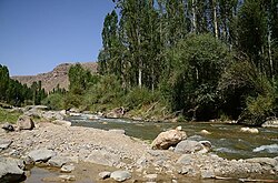
The Simineh River, also known as the Tatavi Chay, is a river in northern Iran, arising in the Zagros Mountains of Kurdistan Province north of Saqqez, that flows into the south end of Lake Urmia. It is just over 200 kilometres (124 mi) long and has a catchment basin (watershed) of 2,090 square kilometres (810 sq mi). Its waters are used primarily for agriculture and the return flow significantly degrades its water quality.

Oued Merguellil is a stream in central Tunisia that flows via Sebkhet Cherita Lake, into the Mediterranean at the Gulf of Hammamet.
The Gidabo River is a medium-sized perennial river of south-central Ethiopia within the Great Rift Valley. The Gidabo River catchment area is one of the leading coffee production areas in Ethiopia.