Zone 6 of Milan

Last updated
Zona 6 di Milano
Municipality 6
Canal Naviglio Grande - Milan (IT25) - 2022-09-02 - 5.jpg
Zone 6 in Milan.svg
Location of Municipality 6 of Milan
CountryFlag of Italy.svg  Italy
Region Lombardy
Province Metro City of Milan
Comune Milan
Government
  PresidentSanto Minniti (PD)
Area
  Total7.06 sq mi (18.28 km2)
Population
 (2022)
  Total150,159
Time zone UTC+1 (CET)
  Summer (DST) UTC+2 (CEST)
Website Municipality 6

The Zone 6 of Milan, since 2016 officially Municipality 6 of Milan, (in Italian: Zona 6 di Milano, Municipio 6 di Milano) is one of the 9 administrative divisions of Milan, Italy. [1]

Contents

It was officially created as an administrative subdivision during the 1980s. On 14 April 2016, in order to promote a reform on the municipal administrative decentralization, the City Council of Milan established the new Municipality 6, a new administrative body responsible for running most local services, such as schools, social services, waste collection, roads, parks, libraries and local commerce. [2]

On 5 March 1999 the new Zone 6, which corresponds to the south-western part of the city, was made up by the union of the previous Zones 16 (Barona, Ronchetto sul Naviglio), 17 (Lorenteggio, Inganni), and 5 (Porta Ticinese, Porta Genova).

Subdivision

The borough includes the following districts:

Porta Ticinese. Porte Ticinese - Milan (IT25) - 2022-09-02 - 3.jpg
Porta Ticinese.

Darsena

The borough's famous Navigli are still today connected to the Darsena, an artificial water basin located near Porta Ticinese which was used for the mooring and the storage of the boats. Considered one the most important junction for the commercial river traffic, the Darsena has two tributaries: Naviglio Grande and Naviglio Pavese. It measures 750 meters in length and 25 meters in width; it has an area of 17,500 square meters and a depth of one and a half meters.

Commissioned and built in 1603 as a transformation into a real port of the pre-existing Sant'Eustorgio lake by the Spanish governor Pedro Enríquez de Acevedo, the Darsena was used as commercial dock till 1979. After years of neglect, in 2015 it was renovated and reopened to the public. This renovation was carried out in view of the Expo 2015.

Paolo Monti - Servizio fotografico (Milano, 1980) - BEIC 6330689.jpg
Milano darsena 2011 06.jpg
Darsena di Milano - 2015.jpg
Historical evolution of the Darsena, here photographed in the early 1980s when it was a commercial dock (left), dry and abandoned in 2011 (centre) and restored as a pedestrian zone in 2015 (right).

Municipal government

The area has its own local authority called Consiglio di Municipio (Municipal Council), composed by the President and 30 members directly elected by citizens every five years. The Council is responsible for most local services, such as schools, social services, waste collection, roads, parks, libraries and local commerce in the area, [3] and manages funds (if any) provided by the city government for specific purposes, such as those intended to guarantee the right to education for poorer families.

The current President is Santo Minniti (PD), elected on 19 June 2016 and re-elected on 3–4 October 2021.

Here is the current composition of the Municipal Council after 2021 municipal election:

Alliance or
political party
MembersComposition
2021–2026
Centre-left
(PD-EV)
18
18 / 30
Milan Municipio 6 Municipal Council 2021.svg
Centre-right
(FI-L-FdI-UDC)
10
10 / 30
M5S 1
1 / 30
Italexit 1
1 / 30

Here is a full lists of the directly elected Presidents of Municipio since 2011:

PresidentTerm of officeParty
Gabriele Rabaiotti16 May 201127 June 2016 PD
Santo Minniti27 June 2016Incumbent PD

Education

IULM University Campus Universita IULM .jpg
IULM University Campus

In this borough are located 22 primary schools, 15 secondary schools and 9 high schools. The most important university located in the borough is the IULM University, founded in 1968 by Carlo Bo.

Transport

Stations of Milan Metro in the Zone 6:

Future stations of Milan Metro, operative from 2024, will be:

Suburban railway stations in the Zone 6:

Maps

Related Research Articles

<span class="mw-page-title-main">Naviglio Grande</span>

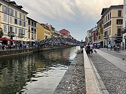
The Naviglio Grande is a canal in Lombardy, northern Italy, connecting the Ticino river near Tornavento to the Porta Ticinese dock, also known as the Darsena, in Milan. It drops 34 m (112 ft) over 49.9 km (31.0 mi). It varies in width from 22 to 50 m from Tornavento to Abbiategrasso, dropping to 15 m (49 ft) between there and Milan. Initially it carries 63 cubic metres per second (2,200 cu ft/s), 116 outlets take water to irrigate 500 square kilometres (190 sq mi) leaving the canal 12 m (39 ft) wide and carrying 12 m3/s (420 cu ft/s) as it enters the dock.

<span class="mw-page-title-main">Navigli</span>

The navigli are a system of interconnected canals in and around Milan, in the Italian region of Lombardy, dating back as far as the Middle Ages.

<span class="mw-page-title-main">Rogoredo</span> Quartiere of Milan in Lombardy, Italy

Rogoredo is a former municipality, currently border district ("quartiere") of the city of Milan, Italy. It is part of the Zone 4 administrative division, and it is located 6–7 km south-east of the city centre. It borders on the Nosedo district to the east, on the Morsenchio district to the north, on the piazzale Corvetto neighbourhood to the north-west, and on the San Donato Milanese comune to the south-east. The name derives from the medieval Latin word robur, meaning "sessile oak, and stands for "oak wood".

<span class="mw-page-title-main">Porta Ticinese</span> Quartiere of Milan in Lombardy, Italy

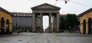
Porta Ticinese is a former city gate of Milan, Italy. The gate, facing south-west, was first created with the Spanish walls of the city, in the 16th century, but the original structure was later demolished and replaced in the early 19th century. The name "Porta Ticinese" is used both to refer to the gate proper and to the surrounding district, part of the Zone 6 administrative division. In the same district there is also a medieval gate with the same name, although in common speech the name "Porta Ticinese" is usually assumed to refer to the 19th century gate.

<span class="mw-page-title-main">Porta Genova</span> Quartiere of Milan in Lombardy, Italy

<span class="mw-page-title-main">Ronchetto sul Naviglio</span> Quartiere of Milan in Lombardy, Italy

Ronchetto sul Naviglio is a district ("quartiere") of Milan, Italy, part of the Zone 6 administrative division of the city. Before being annexed to Milan, it has been an autonomous comune until 1870, and a frazione of Buccinasco between 1870 and 1923.

<span class="mw-page-title-main">Giambellino-Lorenteggio</span> Quartiere of Milan in Lombardy, Italy

Giambellino and Lorenteggio are two historical and populous residential neighborhoods of Milan, Italy. Together, they form a district ("quartiere"), part of the Zone 6 administrative division of Milan.

<span class="mw-page-title-main">Zone 2 of Milan</span> Zona of Milan in Lombardy, Italy

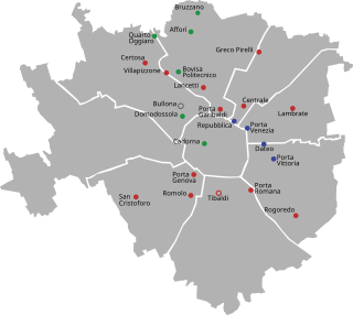
The Zone 2 of Milan is one of the 9 administrative zones of Milan, Italy. In the "sunburst" geometry of the zones of Milan, Zone 2 is the slice that connects the centre to the periphery in the north-east direction.

The city Milan, Italy, has had three different systems of defending walls. The oldest, Roman walls were developed in two stages, the first in the Republican and the second in the Imperial era. The second wall system was realized in the Middle Ages, after the destruction of the city by Frederick I Barbarossa. Finally, the latest wall system was built by the Spanish rulers. While very little remains of these walls, their structure is clearly reflected in the urbanistic layout of the city. In particular, modern Milan has two roughly circular rings of streets, namely the "Cerchia dei Navigli" and the "Cerchia dei Bastioni", which essentially correspond to the Medieval and Spanish walls, respectively. Note that a third ring of roads just beyond the Inner Ring Road, called the External Ring Road, does not owe itself to any old city walls; but was part of the 1884 Beruto Plan for the city of Milan, created and named after a municipal engineer and public servant to the local city government.

<span class="mw-page-title-main">Railway stations in Milan</span>

Milan has 23 railway stations in use today. Of these, 18 are managed by RFI, while the remaining 6 are operated by Ferrovienord. Three more stations are currently under construction or in the planning stage for the city area: Canottieri, Dergano and Zama.

<span class="mw-page-title-main">Oratorio di San Protaso</span>

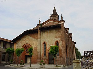
The Oratorio di San Protaso is a church in via Lorenteggio, Milan, Lombardy.

<span class="mw-page-title-main">Zone 1 of Milan</span> Municipality of Milan in Lombardy, Italy

The Zone 1 of Milan, since 2016 officially Municipality 1 of Milan, is one of the 9 administrative divisions of Milan, Italy.

<span class="mw-page-title-main">Parco delle Basiliche</span>

Parco Papa Giovanni Paolo II, best known by its historic name Basilicas Park is a city park of Milan, Italy, located in Zone 1. It owes its name to the fact that it connects two major basilicas, the Basilica of San Lorenzo and the Basilica of Sant'Eustorgio. The park has an overall area of 40.700 m2, bisected by Via Molino delle Armi, one of the avenues comprising the Cerchia dei Navigli ring road.

<span class="mw-page-title-main">Zone 8 of Milan</span> Municipality of Milan in Lombardy, Italy

The Zone 8 of Milan, since 2016 officially Municipality 8 of Milan, is one of the 9 administrative divisions of Milan, Italy.

<span class="mw-page-title-main">Medieval Porta Ticinese</span> Place in Lombardy, Italy

The Medieval Porta Ticinese is a gate of the former 12th-century Walls of Milan; it is located at the intersection of the Corso di Porta Ticinese and Via Edmondo de Amicis and Via Molino di Armi in the city center of Milan, region of Lombardy, Italy. This is one of the three remaining medieval gates of Milan. The others are Porta Nuova and the Pusterla di Sant'Ambrogio.

<span class="mw-page-title-main">Zone 3 of Milan</span> Municipality of Milan in Lombardy, Italy

The Zone 3 of Milan, since 2016 officially Municipality 3 of Milan, is one of the 9 administrative divisions of Milan, Italy.

<span class="mw-page-title-main">Zone 9 of Milan</span> Administrative region of Milan in Lombardy, Italy

The Zone 9 of Milan, since 2016 officially Municipality 9 of Milan, is one of the 9 administrative divisions of Milan, Italy.

<span class="mw-page-title-main">Outline of Milan</span> Overview of and topical guide to Milan

The following outline is provided as an overview of and topical guide to Milan:

<span class="mw-page-title-main">Hydrography of Milan</span>

The hydrography of Milan and the area of the neighboring municipalities is particularly complex, both for natural causes, given the conspicuous presence of rivers, streams and fountains that form a real water tangle, and for issues related to the work of canalization and diversion of waterways made by man, having their beginning during the Roman era, which led to the creation of numerous irrigation ditches, canals and lakes.

References

Commons-logo.svg Media related to Municipio 6 (Milan) at Wikimedia Commons

45°26′24″N9°09′21″E / 45.440087°N 9.155924°E / 45.440087; 9.155924