| Åparken | |
|---|---|
 Åparken and Folkestedet community house | |
| Type | Urban park |
| Location | Aarhus, Denmark |
| Created | 2008 |
| Owned by | Aarhus Municipality |
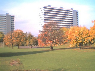
Åparken (The River-park) is a public park in central Aarhus, Denmark. The park is situated by the Aarhus River in the Vesterbro neighborhood in Midtbyen close to CeresByen, bounded by the streets Carls Blochs Gade and Thorvaldsensgade. [1] The park is divided by a central pedestrian pathway which runs from the urban center and connects to the recreational path Brabrandstien towards the west, circumventing Brabrand Lake area. Åparken is the first of a number of green areas extending from the city centre along the river and the pathway of Brabrandstien. The long distance "Aarhus-Silkeborg hiking route" starts off from Åparken.

Aarhus is the second-largest city in Denmark and the seat of Aarhus municipality. It is located on the east coast of the Jutland peninsula, in the geographical centre of Denmark, 187 kilometres (116 mi) northwest of Copenhagen and 289 kilometres (180 mi) north of Hamburg, Germany. The inner urban area contains 273,077 inhabitants and the municipal population is 340,421. Aarhus is the central city in Business Region Aarhus and in the East Jutland metropolitan area, which had a total population of 1.378 million in 2016.
Denmark, officially the Kingdom of Denmark, is a Nordic country and the southernmost of the Scandinavian nations. Denmark lies southwest of Sweden and south of Norway, and is bordered to the south by Germany. The Kingdom of Denmark also comprises two autonomous constituent countries in the North Atlantic Ocean: the Faroe Islands and Greenland. Denmark proper consists of a peninsula, Jutland, and an archipelago of 443 named islands, with the largest being Zealand, Funen and the North Jutlandic Island. The islands are characterised by flat, arable land and sandy coasts, low elevation and a temperate climate. Denmark has a total area of 42,924 km2 (16,573 sq mi), land area of 42,394 km2 (16,368 sq mi), and the total area including Greenland and the Faroe Islands is 2,210,579 km2 (853,509 sq mi), and a population of 5.8 million.

Vesterbro is an area in the city of Aarhus, located in the Aarhus C district to the west of the city centre of Indre By. The neighbourhood is not as old as the historical centre as it was previously farmland outside the city walls. The development of Vesterbro progressed, when the city walls of Aarhus were demolished in 1851.
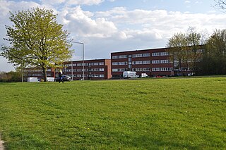
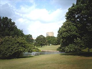
The park is an open grassy area with a few trees and raised flower beds of mixed wildflower. The park contains a number of recreational and play facilities, including a slack lining, hammocks, climbing walls and a berth for canoes, kayaks or general recreation has been constructed at the river. The park is also home to Folkestedet, a municipal community house and organization, aiming to provide facilities for clubs and organizations in the city. Aarhus Tech runs a café here. [2]

A wildflower is a flower that grows in the wild, meaning it was not intentionally seeded or planted. Yet "wildflower" meadows of a few mixed species are sold in seed packets. The term implies that the plant probably is neither a hybrid nor a selected cultivar that is in any way different from the way it appears in the wild as a native plant, even if it is growing where it would not naturally. The term can refer to the flowering plant as a whole, even when not in bloom, and not just the flower.

A hammock is a sling made of fabric, rope, or netting, suspended between two or more points, used for swinging, sleeping, or resting. It normally consists of one or more cloth panels, or a woven network of twine or thin rope stretched with ropes between two firm anchor points such as trees or posts. Hammocks were developed by native inhabitants of Central and South America for sleeping. Later, they were used aboard ships by sailors to enable comfort and maximize available space, and by explorers or soldiers travelling in wooded regions. Eventually, in the 1920s, parents throughout North America used fabric hammocks to contain babies just learning to crawl. Today they are popular around the world for relaxation; they are also used as a lightweight bed on camping trips. The hammock is often seen as a symbol of summer, leisure, relaxation and simple, easy living.
A berth is a designated location in a port or harbour used for mooring vessels when they are not at sea. Berths provide a vertical front which allows safe and secure mooring that can then facilitate the unloading or loading of cargo or people from vessels.
The park was developed partially on top of an underground municipal water reservoir, constructed in 2008-2011. The basin is part of a series of underground reservoirs and a larger effort by the municipality to deal with the increased and increasing levels of rainfall due to climate change. The reservoir can hold 15,000 m3 of water from the river. [3] [4]


 Climbing
 The berth
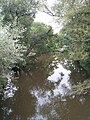

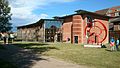 Folkestedet