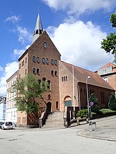
Viby J is a former town and now a district, in the southwestern part of Aarhus in Denmark. The district has almost 30,000 inhabitants. The "J" stands for Jutland, as there is another town called Viby on the island of Zealand, officially referred to as Viby Sj and also a village on Funen.

Aarhus Municipality, previously known as Århus Municipality until 2011, is a municipality in Central Denmark Region, on the east coast of the Jutland peninsula in central Denmark.

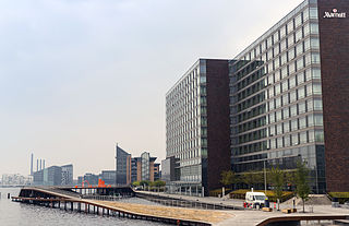
Aarhus C is a postal district in the city of Aarhus, Denmark, consisting of the Inner city, Vesterbro, University of Aarhus, Frederiksbjerg, Langenæs and Aarhus Ø, with postal code 8000. The district is commonly defined as the area enclosed by the ring road of Ring 1, and in the west by the Aarhus Harbour and shoreline.

Vesterbro is one of the 15 administrative, statistical, and city tax districts (bydele) comprising the municipality of Copenhagen, Denmark. It covers an area of 3.76 km², and has a population of 51,466 and a population density of 13,688 per km².

Midtbyen, also known as Aarhus Center or City, is the inner part of Aarhus. Midtbyen is part of district Aarhus C, with postal code 8000, together with Vesterbro, Nørre Stenbro and Frederiksbjerg and it has a population of 55,000.

Aarhus N is a postal district in the city of Aarhus, consisting of Trøjborg, Risskov, Vejlby, Skejby, Vorrevangen and Christiansbjerg, all with postal code 8200. Aarhus N is an abbreviation for Aarhus Nord and is located north of the city centre. It is the highest lying area of Aarhus.
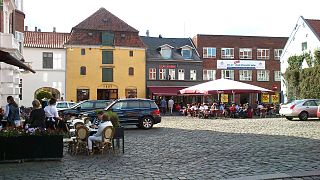
Latinerkvarteret in Aarhus, is the oldest part of the city and is itself part of the inner city. The quarter comprise the streets of Badstuegade, Klostergade, Volden, Studsgade, Borggade, Rosensgade, Mejlgade and Graven, with Pustervig Torv as the main square.
Districts of Copenhagen are often based on informal designations based on historic origins, often with alternative names and loosely defined boundaries. Copenhagen Municipality is divided into 10 official administrative districts but they often comprise areas of a heterogeneous character which are informally not seen as one district. Some districts have earlier been official subdivisions and thus have semi-official boundaries. Copenhagen postal code designations often correspond to district boundaries but in some cases differ from them, as an example parts of the city centre has the postal code København V which is generally associated with Vesterbro.
Kalvebod Brygge is a waterfront area in the Vesterbro district of Copenhagen, Denmark. The name also refers to a section of the Ring 2 ring road which follows the waterfront from Langebro in the north to the H. C. Ørsted Power Station in the south. The area is dominated by office buildings, Tivoli Conference Center, several hotels and the shopping centre Fisketorvet.

An urban district is the name used for urban or municipality districts in some of the larger municipalities of Denmark. The term is not strictly defined, but is usually bigger than a quarter or a city block.

Nørre Stenbro is a small neighborhood in the city of Aarhus, Denmark home to some 3,000 residents. The neighborhood is part of the Aarhus C district and borders the neighborhoods of Indre By south and west, Aarhus Docklands in the east and Trøjborg north. The residential area of Nørre Stenbro is delimited by the streets Nørre Boulevard, Østboulevarden, Østbanetorvet, Kystvejen, Nørreport and Nørrebrogade, but the large Nordre Cemetery and the smaller residential quarter of Skovvejskvarteret is also part of the same registration.
Indre By is a neighborhood in the city of Aarhus, Denmark. The neighborhood is bounded by Nørre Allé, Vester Allé and Sønder Allé and is composed of the neighborhood and historical centre of the Latin Quarter and the areas around the Central Station and the City Hall Park. The neighborhood is one of the three main neighborhoods in the district of Aarhus C, along with Frederiksbjerg and Vesterbro.
Aarhus Municipality is divided in many different ways, often on layered levels. Politically it is a part of the multi-member constituency Østjyllands Storkreds which covers the eastern coast of East Jutland from Randers to Vejle Fjord. Aarhus Municipality itself is divided in 4 folketing constituencies, Århus Sydkredsen, Århus Vestkredsen, Århus Nordkredsen, Århus Østkredsen, which are again divided in a total of 45 wards, each with one polling station. The diocese of Aarhus is divided in a number of deaneries of which 4 resides in Aarhus Municipality with a total of 58 parishes. Administratively Aarhus Municipality operates with 25 districts or local communities (Lokalsamfund) which can be amalgamations of parishes, neighborhoods or former and present towns. In addition there are 28 postal districts within the municipality, some of which are colloquially used to denote areas and neighborhoods in the city of Aarhus. The urban area and immediate suburbs of the city of Aarhus are divided in the postal (P.D.) districts Aarhus C, Aarhus N, Aarhus V, Viby J, Højbjerg, Brabrand and Risskov.

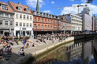
Åparken is a public park in central Aarhus, Denmark. The park is situated by the Aarhus River in the Vesterbro neighborhood in Midtbyen close to CeresByen, bounded by the streets Carls Blochs Gade and Thorvaldsensgade. The park is divided by a central pedestrian pathway which runs from the urban center and connects to the recreational path Brabrandstien towards the west, circumventing Brabrand Lake area. Åparken is the first of a number of green areas extending from the city centre along the river and the pathway of Brabrandstien. The long distance "Aarhus-Silkeborg hiking route" starts off from Åparken.
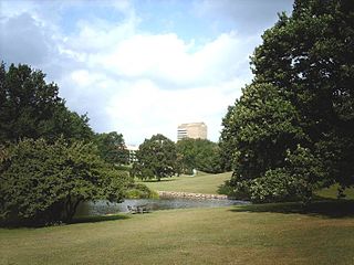
Aarhus University Park or the University Park is a public park in central Aarhus, Denmark. The University Park is at the centre of Aarhus University's main campus.

Vestergade is a street in Aarhus, Denmark, which runs east to west from the central square of Store Torv to the city park of Åparken at Carl Blochs Gade, intersecting the main streets of Grønnegade and Vester Allé along its course. Vestergade begins in the Indre By neighborhood and ends in neighborhood of Vesterbro, close to CeresByen. Vestergade has some of the best preserved 18th-century merchant estates in Aarhus and a history of creativity and artistic expression.

Klostergade is a street in Aarhus which runs east from Grønnegade to Studsgade, intersecting a number of streets.

The architecture of Aarhus comprises numerous architectural styles and works from the Middle Ages to present-day. Aarhus has a well-preserved medieval city center with the oldest dwellings dating back to the mid-1500s and some ecclesiastical structures such as St. Clemen's Cathedral and numerous smaller churches that can be traced back to the 1100s. The industrialization of the 19th and 20th centuries left distinctive industrial structures, important National romantic works and some of the best examples of Functionalist architecture in the country. The history of the city as a Viking fort is evidenced in the street layout of the Latin Quarter, the wider Indre By neighborhood testifies to its later role as a Market town and center of commerce while the Frederiksbjerg, Trøjborg and Marselisborg districts showcase the first cohesive urban planning efforts of the early 20th century.

Vesterbro Torv is a public square located in the Vesterbro neighborhood of Aarhus, Denmark. Vesterbro Torv is the junction where 8 street meet; Vesterbrogade, Hjortensgade, Langelandsgade, Teglværksgade, Nørre Allé, Vesterport, Vester Allé and Janus la Cours Gade. It is one of the most heavily trafficked areas in the city, receiving traffic from Åbyhøj and Brabrand in the west along Silkeborgvej and from Tilst in the north-west along Viborgvej. The square is designed as a central "island" surrounded by streets. The central part is primarily used for parking although there is a few recreational facilities such as public toilets and benches.

Langelandsgade is a street in Aarhus, Denmark.