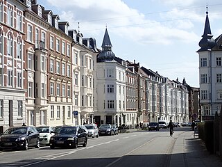
Aarhus Festuge is a 10-day arts and culture festival in the city of Aarhus, Denmark. It takes place every year in late August to early September, in week 35-36. Since its start in 1965, the festival has grown to become one of the largest cultural events in Scandinavia and showcases a mix of local, national and international artists.
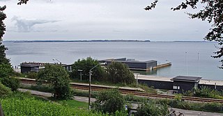
Den Permanente is a sea bath and a beach in Aarhus, Denmark.

Skåde is a neighbourhood of Højbjerg, a southern district of Aarhus in Denmark. It is located 6 km south from the city centre.

Langenæs is a small neighborhood in the city of Aarhus, Denmark with about 6,500 residents, as of 2014. The neighborhood is part of the district Midtbyen and borders the neighborhoods of Frederiksbjerg and Marselisborg to the East and the district of Viby to the South. Langenæs is delimited by the streets Søndre Ringgade, Skanderborgvej, Marselis Boulevard and the valley of Brabrand Ådal.

Constantin Marselis, or Constantijn Marselis, was a nobleman of the wealthy Dutch Marselis family.
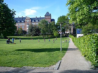
Skanseparken is one of the oldest parks in the city of Aarhus. It is situated in the neighborhood of Frederiksbjerg in Midtbyen. Skanseparken was constructed in the years 1901 to 1902 between the streets Strandvejen, Marselisborg Allé and Heibergsgade. The park is typical of the parks in the city with large, open areas bounded by beech trees, raised flower beds and playgrounds. It is a popular area for festivals, concerts and other cultural events.
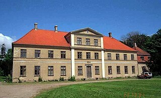
Vilhelmsborg is the National Equestrian Centre of Denmark and a listed building in Aarhus Municipality. The main manor building was completed in 1842 and was listed by the Danish Heritage Agency on 3 March 1945. The manor lies 10 km. south of Aarhus, by Beder-Malling in Mårslet Parish, and is today owned by Aarhus Municipality along with 288 hectares of adjoining land.

Moesgård is a former manor house and a listed building in Aarhus Municipality. The current buildings were completed in 1778 and was listed in the Danish registry of protected buildings and places by the Danish Heritage Agency on 17 July 1918.

Skansepalæet is a residential building in Aarhus, Denmark situated in the Frederiksbjerg neighborhood. The building comprises Standvejen 34-36 and Heibergsgade 25-27. Skansepalæet was built in 1908 by designs of the Danish architect Hjalmar Kjær as a hotel in connection with the Danish National Exhibition of 1909. Today the building is an apartment complex owned by its residents.

Constantinsborg is a manor in Aarhus Municipality, Denmark which has existed since at least 1400. The manor is situated at the southern shore of Årslev Engsø; a newly created nature site and shallow lake extension of the Brabrand Lake, in Viby J 10 km. south-west of Aarhus. The manor and estate is today privately owned and operated as a farm. Constantinsborg was originally known as Stadsgaard but was later renamed for Constantin Marselis who owned the estate in the 1600s. In the 1800s the Pontoppidan-family owned the estate and came to have a large impact on Danish agriculture and the transformation of the moors in Jutland to agricultural land. The main manor building was constructed in the early 1800s while adjoining farm buildings date back to 1870 and the 20th century.

Marselisborg was a farm, manor and barony in Aarhus, Denmark which existed through the 1200s to 1910 under varying ownership and status. The original farm was situated in the present day Marselisborg neighborhood south of the city centre. In 1896 the city of Aarhus purchased the manor and in 1911 dissolved the estate and sold the land off for development. The manor was named after and by Gabriel Marselis who was the first private owner and many landmarks in the area are in turn named for the manor such as Marselisborg Forests, Marselisborg Hospital and Marselisborg Palace.
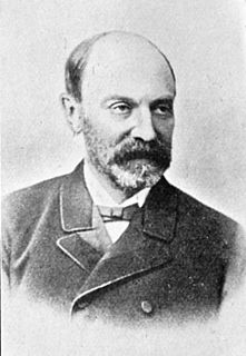
Hans Peter Ingerslev was a Danish politician and minister. He was born in 1831 on Marselisborg Manor in Aarhus, owned by his parents Caspar Peder Rothe Ingerslev and Marie Meulengracht.
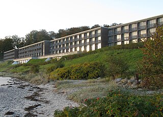
Hotel Marselis or Marselis Hotel - Aarhus is a hotel in Aarhus, Denmark. It is located in the Marselisborg Forests, in the Højbjerg district. It overlooks the Bay of Aarhus from a prominent position on the coast. The hotel is owned by the company Helnan Hotels which also operates a hotel in Aalborg. The hotel includes 163 rooms and beyond common amenities also feature conference and meeting rooms. Marselis Hotel is a four star hotel (2016) and is member of the Danish hotel organization Horesta.
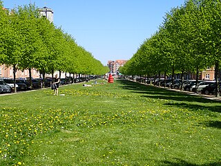
Ingerslevs Boulevard is a street in Aarhus, Denmark. It is 500 meters long and runs west to east from Harald Jensen's Plads to Skt. Anna Gade. The street is situated in the Frederiksbjerg neighborhood where it is functionally the main street but parts of it also acts as a public green space owing to width and central lawn. Ingerslevs Boulevard is home to St. Luke's Church and two schools, N.J. Fjordgade's School and Frederiksbjerg School. It is a mostly residential area but the street itself hosts a farmer's markets twice a week. Ingerslevs Boulevard was developed in the early 20th century as a main component of Frederiksbjerg when the neighborhood was created based on a unified urban planning design.


