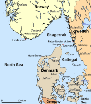
The Kattegat is a 30,000 km2 (12,000 sq mi) sea area bounded by the Jutlandic peninsula in the west, the Danish straits islands of Denmark and the Baltic Sea to the south and the provinces of Bohuslän, Västergötland, Halland and Skåne in Sweden in the east. The Baltic Sea drains into the Kattegat through the Danish straits. The sea area is a continuation of the Skagerrak and may be seen as a bay of the North Sea and North Atlantic Ocean, but in traditional Scandinavian usage, this is not the case.

Samsø is a Danish island in the Kattegat 15 kilometers (9.3 mi) off the Jutland Peninsula. Samsø is located in Samsø municipality. The community has 3,724 inhabitants (2017) called Samsings and is 114 km² in area. Due to its central location, the island was used during the Viking Age as a meeting place. The etymology of the island's name is unknown.

Tunø is a Danish island in the Kattegat, approximately 4 km west of the neighbouring island of Samsø. The island covers an area of 3.52 square kilometres, has a circumference of 9.5 km (5.9 mi) and has total of 66 inhabitants as of November 2022. It comes under the administration of Odder municipality. Tunø By is the only village on the island, with the hamlet of Løkkegårde as the second most populated area.

Endelave is a Danish island in the Kattegat, north of Odense, off the coast of Funen, and west of Samsø. The island covers an area of 13.2 km2 (5.1 sq mi) and has 185 inhabitants.

Kalundborg Municipality is a kommune in the Region Sjælland on the west coast of the island of Zealand in Denmark. The municipality covers an area of 604 km2 (233 sq mi), and has a total population of 48,309. Its mayor is Martin Damm, a member of Venstre. The main town and the site of its municipal council is the city of Kalundborg.

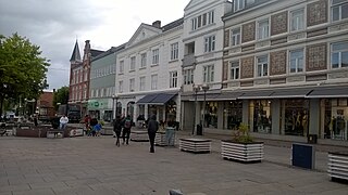
Until 1 January 2007, Ebeltoft municipality was a municipality in Aarhus County on the east coast of the Jutland peninsula in central Denmark. The region lies in a geographic region known as southern Djursland, and more specifically Mols. The municipality covered an area of 276 km2, and had a total population of 14.997 (2003). Its last mayor was Jørgen Brøgger. The main town and the site of its municipal council was the town of Ebeltoft.
Odder Municipality is a municipality in the Central Denmark Region on the east coast of the Jutland peninsula in Central Denmark south of Aarhus. It is a part of the greater Aarhus area. The municipality covers an area of 225.04 km², including the islands of Alrø and Tunø. It borders Aarhus Municipality to the north, Skanderborg Municipality to the north-west and Horsens Municipality to the west. It also connects to Hedensted Municipality across Horsens Fjord to the south, and connects to Samsø Municipality through a ferry route.
East Jutland metropolitan area is a potential metropolitan area in Jutland and Funen, Denmark. Aarhus is the most populated city in the region.

Kalø Castle is a ruined castle located in eastern Jutland, in Denmark, 20 km from the city of Aarhus within Mols Bjerge National Park.

Mols Bjerge National Park or Nationalpark Mols Bjerge is a Danish national park in the area known as Mols Bjerge in Syddjurs Municipality, Central Jutland, inaugurated on 29 August 2009. The protected area, measures 180 square kilometres (69 sq mi) in size. The Mols Hills, reaching a height of 137 metres (449 ft), are centrally located in the park, and take up 2,500 ha. "More than half of all wild Danish plant species" can be found at Mols Bjerge.

Trehøje is a Danish vista point with a view of the sea to the east, south and west, located in the Mols Bjerge National Park on the peninsula Djursland between Denmark and Sweden. Three large bronze-age barrows close to each other 127 meters above the sea, have given their name to the place, which contains a group of 22 barrows. "Trehøje" meaning three mounds, is one of four major vista points in the hills of Mols, each with a barrow on top. The others are Ellemandsbjerg, Stabelhøje and Agri Baunehøj.

Sletterhage Lighthouse is located in Denmark on the southern tip of the Djursland peninsula protruding into the Kattegat between Denmark and Sweden at the entrance to the Baltic Sea. The concrete lighthouse was built in 1894 to help guide ships to and from the Port of Aarhus, via a shipping lane that passes close to the lighthouse isthmus.

Stabelhøje or Stabel Høje are two Bronze Age Mounds 135 meters and 133 meters above sea level by the village Agri in Mols Bjerge on the peninsula Djursland in Denmark at the entrance to The Baltic Sea in Northern Europe. The burial mounds date back to the early Bronze Ages 1800–1000 years B.C. These hills are some of the more known view points in Mols Bjerge National Park. Other view points in the area are Agri Baunehøj, Trehøje, Ellemandsbjerg and Jernhatten.

Hestehave Wood on southern Djursland in Denmark, Northern Europe, at the entrance to The Baltic Sea between Denmark and Sweden, is a recreational wood with a temperate coastal climate, owned by the Danish state. Hestehave is located close to the town Rønde, 21 miles north of the second largest city in Denmark, Aarhus.

Kalø Vig is a cove in the north end of the Bay of Aarhus, Denmark. It stretches in a semicircle from Skæring in the North West to Kalø Castle below Rønde in the North to the peninsula Skødshoved in the East. The area around Kalø Castle became a nature preserve in 1939 and is now a part of Mols Bjerge National Park. Sight lines over the cove from Hjelmager south of Løgten are subject to conservation and preservation rules.

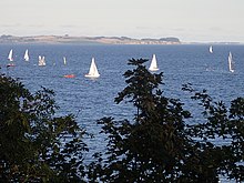
Aarhus Sejlklub is one of the oldest yacht clubs in Denmark. It was established in 1879 in Aarhus, Central Denmark Region and is based out of the Aarhus Docklands. Aarhus Sejlklub is in the premiere division of the Danish League of Sail Sports and is a member of Sailing Aarhus which will host the ISAF Sailing World Championships in 2018.

Åkrogen is an urban, public beach and park in the northern parts of Aarhus, Denmark.

Tunø Knob Offshore Wind Farm is an offshore wind farm in the Bay of Aarhus, Denmark. It is located on the sandbar Tunø Knob, west of the Tunø island.