This article needs additional citations for verification .(January 2017) |

Ring 2, or Ringvejen, is the outermost ring road surrounding the city of Aarhus in Denmark.
This article needs additional citations for verification .(January 2017) |
Ring 2, or Ringvejen, is the outermost ring road surrounding the city of Aarhus in Denmark.
Ring 2 bounds the outer neighborhoods of the central urban area. It is part of the Danish national road network and is numbered O2, the letter 'O' denoting it is a ring road. The total length of the road is about 14.5 km.
Ring 2 is composed of 6 stretches of road, from Ringvej Syd in the South in Viby to Vejlby Ringvej in the North in Vejlby and Risskov. Ringvej Syd, the southernmost section of the ring road, is connected to the rest of Ring 2 via a small 1.4 km stretch of Skanderborgvej. Other than the small connecting stretch, the long intercity motorway of Skanderborgvej is not a part of Ring 2.
| Road name |
|---|
| Ringvej Syd |
| Skanderborgvej (small connecting stretch) |
| Viby Ringvej |
| Åby Ringvej |
| Hasle Ringvej |
| Vejlby Ringvej |
Ideas and plans for construction of another ring road around Aarhus began in the 1930s, before the first ring road of Ring 1 was even finished. Construction of Ring 2 commenced in the 1950s but was then put on hold for decades, due to uncertainty of other nearby traffic projects, until it was finally finished in 1987. [1]
As in many other cities of Denmark, the residential areas around Ring 2 in Aarhus, has been under urban renewal since the beginning of the new millennium. [2]
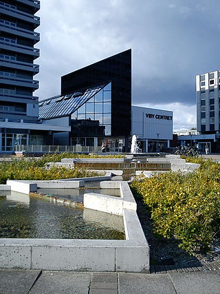
Viby J is a former town and now a district, in the southwestern part of Aarhus in Denmark. The district has almost 30,000 inhabitants. The "J" stands for Jutland, as there is another town called Viby on the island of Zealand, officially referred to as Viby Sj and also a village on Funen.

Skejby is a neighbourhood and former village in Aarhus, Denmark. The neighbourhood is part of the city district Aarhus N.

Brabrand is a postal district of Aarhus Municipality, Denmark. South of Brabrand, in the Aarhus river-valley, is the largest recreational area of Aarhus Municipality, comprising the Brabrand Lake and the meadow-lake of Årslev, with surrounding natural sites.

Aarhus Municipality, known as Århus Municipality until 2011, is a kommune in the Central Denmark Region, on the east coast of the Jutland peninsula in central Denmark.

Holme is a neighbourhood in the district of Højbjerg in Aarhus, Denmark. It is located 5km south of the city center.

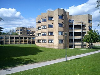
Stavtrup is a western suburb of Aarhus in Denmark. It is located 7 km from the city centre and has a population of 3,729. Since 1 January 2011, Stavtrup is officially a part of Aarhus' urban area under the postal district of Viby J.
Vejlby is a north-eastern neighbourhood of Aarhus in Denmark. It is located 5km from the city centre and is administratively part of the district of Risskov.
Aarhus N is a postal district in the city of Aarhus, consisting of Trøjborg, Risskov, Vejlby, Skejby, Vorrevangen and Christiansbjerg, all with postal code 8200. Aarhus N is an abbreviation for Aarhus Nord and is located north of the city centre. It is the highest lying area of Aarhus.
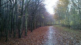
Mollerup Skov is a 97 hectare relatively new forest situated in the northern outskirts of the city of Aarhus, Denmark. In the neighbourhood of Vejlby and Skejby between Skejbyvej, Langengevej and Skejby Nordlandsvej to be precise.

Egå Engsø is an artificial lake and wetland site located in the north of the town of Aarhus between Vejlby, Risskov and Lystrup. Engsø means 'meadow lake' and Egå means 'oak stream', referring to the stream that drains the lake into the Aarhus bay. The lake area is bordered by the Djursland motorway to the north and the Aarhus-Grenaa railway and the municipal heating pipes from Studstrup Power Station to the south and west.

Skjoldhøjkilen is a recreational and natural site, in the district of Brabrand in the western part of Aarhus in Denmark. It stretches westwards from Hasle Hills, like a wavy green strip of meadows, small lakes and woodlands. It is 3.5 km long and just as Hasle Hills, it is administered by the self-governing institution 'Hasle Bakker'.
Vejlby-Risskov Idrætscenter is a sports complex located in Aarhus, Denmark. It is the largest of its kind in East Jutland. The complex is situated in the district of Vejlby-Risskov in the northern part of Aarhus. Its central parts consist of Vejlby Stadium, home ground of association football club VSK Aarhus, and Vejlby-Risskov Hallen, the home of basketball team Bakken Bears.

Ormslev is a small village in Aarhus Municipality, Central Denmark Region in Denmark with a population of 370.

Ring 1, or Ringgaden, is a ring road that surrounds the most central part of Aarhus, Denmark, roughly bounding the neighborhood of Midtbyen. It is part of the Danish national road network and is numbered O1, denoting a ring road. The total length of the road is about 8.8 km.

Risskov Gymnasium is a school of secondary education and a Danish gymnasium in Aarhus, Denmark. The school is a financially independent self-owning educational institution under the Danish state. The school offers the 3 year matriculation examination (STX) programme within four main branches: natural sciences, political sciences, language and art.
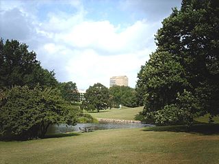
Aarhus University Park or the University Park is a public park in central Aarhus, Denmark. The University Park is at the centre of Aarhus University's main campus.
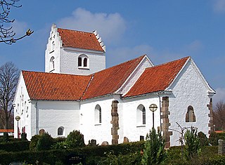
Vejlby Church is a church located in Vejlby Parish in Aarhus, Denmark. The church is situated 2 kilometres (1.2 mi) north of Aarhus city centre, west of Risskov and the Bay of Aarhus, on the morainal hills of the Egå valley, with a view of Kalø Vig and Helgenæs. It is a parish church belonging to the Church of Denmark. The parish has a population of 7,148 (2015).
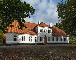
Jarlsminde is a farm and a listed building in Aarhus, Denmark. The farm was built in 1798 and was listed in the Danish national registry of protected buildings and places by the Danish Heritage Agency on 3 June 1997. The farm is situated in the suburb Stavtrup about 7-8 km. south-west of the city centre of Aarhus where it sits on a hill with a view of Brabrand Lake and the large urban areas on the other side of it.

The architecture of Aarhus comprises numerous architectural styles and works from the Middle Ages to present-day. Aarhus has a well-preserved medieval city center with the oldest dwellings dating back to the mid-1500s and some ecclesiastical structures such as St. Clemen's Cathedral and numerous smaller churches that can be traced back to the 1100s. The industrialization of the 19th and 20th centuries left distinctive industrial structures, important National romantic works and some of the best examples of Functionalist architecture in the country. The history of the city as a Viking fort is evidenced in the street layout of the Latin Quarter, the wider Indre By neighborhood testifies to its later role as a Market town and center of commerce while the Frederiksbjerg, Trøjborg and Marselisborg districts showcase the first cohesive urban planning efforts of the early 20th century.

Riisvangen Stadion is an association football stadium in Aarhus N. It is the home stadium of Danish 2nd Division club Aarhus Fremad. Stadium capacity is 5,000, but the attendance record is 3,200 which occurred when the club competed in the Danish Superliga, in a matchup against Ikast fS on 2 November 1997.
56°6′9″N10°12′23″E / 56.10250°N 10.20639°E
| | This European road or road transport-related article is a stub. You can help Wikipedia by expanding it. |
| | This article about transport in Denmark is a stub. You can help Wikipedia by expanding it. |