
Aarhus is the second-largest city in Denmark and the seat of Aarhus Municipality. It is located on the eastern shore of Jutland in the Kattegat sea and approximately 187 kilometres (116 mi) northwest of Copenhagen.

Skanderborg is a town in Skanderborg Municipality, Denmark. It is situated on the north and north eastern brinks of Skanderborg Lake and there are several smaller ponds and bodies of water within the city itself, like Lillesø, Sortesø, Døj Sø and the swampy boglands of Eskebæk Mose. Just north of the town on the other side of Expressway E45, is the archaeologically important Illerup Ådal. Over time, the town has grown into a suburb of Aarhus to the north east, connected by the urban areas of Stilling, Hørning and Hasselager.

Skejby is a neighbourhood and former village in Aarhus, Denmark. The neighbourhood is part of the city district Aarhus N.

Brabrand is a postal district of Aarhus Municipality, Denmark. South of Brabrand, in the Aarhus river-valley, is the largest recreational area of Aarhus Municipality, comprising the Brabrand Lake and the meadow-lake of Årslev, with surrounding natural sites.
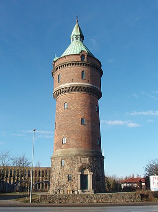
Aarhus N is a postal district in the city of Aarhus, consisting of Trøjborg, Risskov, Vejlby, Skejby, Vorrevangen and Christiansbjerg, all with postal code 8200. Aarhus N is an abbreviation for Aarhus Nord and is located north of the city centre. It is the highest lying area of Aarhus.

Riis Skov is a forest and park in Århus, Denmark. It is located south of the district of Risskov, along the Bay of Aarhus.
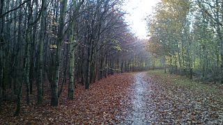
Mollerup Skov is a 97 hectare relatively new forest situated in the northern outskirts of the city of Aarhus, Denmark. In the neighbourhood of Vejlby and Skejby between Skejbyvej, Langengevej and Skejby Nordlandsvej to be precise.

Egå Engsø is an artificial lake and wetland site located in the north of the town of Aarhus between Vejlby, Risskov and Lystrup. Engsø means 'meadow lake' and Egå means 'oak stream', referring to the stream that drains the lake into the Aarhus bay. The lake area is bordered by the Djursland motorway to the north and the Aarhus-Grenaa railway and the municipal heating pipes from Studstrup Power Station to the south and west.

Skjoldhøjkilen is a recreational and natural site, in the district of Brabrand in the western part of Aarhus in Denmark. It stretches westwards from Hasle Hills, like a wavy green strip of meadows, small lakes and woodlands. It is 3.5 km long and just as Hasle Hills, it is administered by the self-governing institution 'Hasle Bakker'.

Brabrand Lake is a lake in the district of Brabrand (Gellerup), west of Aarhus city, Denmark. The Aarhus River passes through Brabrand Lake and it is possible to canoe all the way to the inner city from here. The lake is oblong-shaped.

Mindeparken is a memorial park and recreational area in the south of Aarhus City, next to Marselisborg Palace.

Marselisborg Forests, or simply Marselisborg Forest, is a 550 hectares forest to the south of Aarhus City in the Kingdom of Denmark. Many present day sources now includes the forest of Fløjstrup, as part of the Marselisborg Forests, upping the total area with another 200 hectares. Marselisborg Forests runs along the coastline of the Aarhus Bay in a hilly terrain with steep slopes and deep gullies, especially at the shoreline. There are many traces of prehistoric activities here and the landscape have been covered by woodlands for thousands of years.
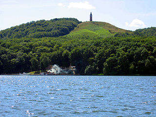
Søhøjlandet is the highest lying region in Denmark and at the same time, it has the highest density of lakes.
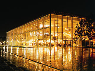
Musikhuset Aarhus is a large concert hall complex in Aarhus, Denmark. Located in the city centre, Musikhuset is Aarhus' main venue for music and with seating for more than 3,600 people in total, it is the largest concert hall in Scandinavia. Musikhuset Aarhus was designed by Kjær & Richter and built in 1979–1982, commissioned by Aarhus Municipality.
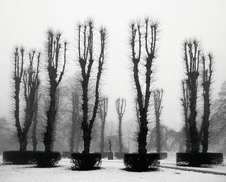
Rådhusparken is a public park in central Aarhus, Denmark. The park is situated by the City Hall in the Indre By neighborhood of Midtbyen, between the streets Frederiks Allé to the west and Park Allé to the east. The park lies within a scenic semi-circle of some of the more important cultural and political institutions in the city; the Concert Hall, the ARoS Art Museum, Vester Allés Kaserne and the city hall. The City Hall Park was listed along with the adjacent city hall on 10 March 1995.

The Concert Hall Park is a public park in central Aarhus, Denmark. The park is laid out in front of the Aarhus Concert Hall main entrances in the Indre By neighborhood of the inner city. It is bordered by the street Frederiks Allé to the east, Thomas Jensen's Allé to the south and Vester Allé to the north, behind the historic buildings of the former Vester Allés Barracks. The park is named after the Aarhus Concert Hall which is situated prominently immediately west of the park. The Concert Hall Park forms a center-point between some of the most prominent buildings in the city, the ARoS Aarhus Art Museum, Vester Allé Barracks, the concert halls, and Aarhus City Hall in view behind the City Hall Park across Frederiks Allé. The Concert Hall Park was designed by the landscape architect Sven Hansen as a parterre garden, and it was established in the 1980s.

The architecture of Aarhus comprises numerous architectural styles and works from the Middle Ages to present-day. Aarhus has a well-preserved medieval city center with the oldest dwellings dating back to the mid-1500s and some ecclesiastical structures such as St. Clemen's Cathedral and numerous smaller churches that can be traced back to the 1100s. The industrialization of the 19th and 20th centuries left distinctive industrial structures, important National romantic works and some of the best examples of Functionalist architecture in the country. The history of the city as a Viking fort is evidenced in the street layout of the Latin Quarter, the wider Indre By neighborhood testifies to its later role as a Market town and center of commerce while the Frederiksbjerg, Trøjborg and Marselisborg districts showcase the first cohesive urban planning efforts of the early 20th century.

Marienlyst Park is a public park in Hasle in the Aarhus V district, north-west Aarhus, Denmark. The park is situated west of the Herredsvang neighborhood along the street Fjældevænget Busvej to the south and Brendstrup Forest to the west. Marienlyst Park is one of the largest parks in Aarhus and features both landscaped lawns and artificial forested hills. Facilities include an amphitheatre, soccer fields, playgrounds and a 6-hole golf course. Marienlyst Park was established in connection with the development of western Hasle in the 1970s and today forms part of a green corridor extending from Vestereng to Brabrand Lake. The park is owned by Aarhus Municipality and is managed by the municipal department Natur og Miljø. Marienlyst Park can be rented for public events.

Ballehage Beach is an urban, public beach in the southern parts of Aarhus, Denmark and since 1929 it has been one of the oldest sea baths in Denmark. Ballehage Beach is situated in the Marselisborg Forests on the Bay of Aarhus in the suburb of Højbjerg, south of Marselisborg Yacht Harbour and the Aarhus River mouth. Helgenæs lies across the bay to the east, a bit inland to the west is the Marselisborg Deer Park and to the north is the Varna Palace. The beach area is some 1,000 metres long and between 10 and 30 metres wide. It is a white sandy beach with occasional rows of boulders extending into the sea, for coastal erosion protection. Ballehage Beach is popular for sunbathing and swimming due to the shielding effect and scenic view of the nearby forest on the steep hillsides to the west. The beach has a single jetty extending some 20 metres into the sea, offering a platform to jump from or relax on. There are outdoor changing facilities, toilets and storage areas. The Beach is open year-round for everyone at no charge.
Business Park Skejby is a large business park in the northern district of Aarhus N, in the city of Aarhus, Denmark.


