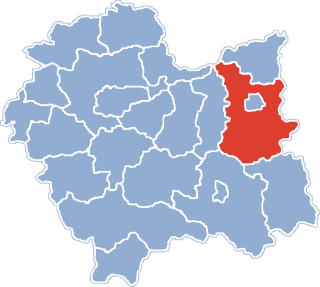
Wojnicz is a town in Tarnów County, Lesser Poland Voivodeship. In the early times of the Polish state, it used to be one of the most important centers of the province of Lesser Poland. The Battle of Wojnicz took place here on September 23, 1655, against Sweden.

Bogoniowice is a village in the administrative district of Gmina Ciężkowice, within Tarnów County, Lesser Poland Voivodeship, in southern Poland. It lies approximately 1 kilometre (1 mi) south-west of Ciężkowice, 26 km (16 mi) south of Tarnów, and 80 km (50 mi) east of the regional capital Kraków.
Falkowa is a village in the administrative district of Gmina Ciężkowice, within Tarnów County, Lesser Poland Voivodeship, in southern Poland. It lies approximately 10 kilometres (6 mi) south-west of Ciężkowice, 35 km (22 mi) south of Tarnów, and 77 km (48 mi) south-east of the regional capital Kraków.
Kąśna Górna is a village in the administrative district of Gmina Ciężkowice, within Tarnów County, Lesser Poland Voivodeship, in southern Poland. It lies approximately 7 kilometres (4 mi) west of Ciężkowice, 29 km (18 mi) south of Tarnów, and 75 km (47 mi) south-east of the regional capital Kraków.
Tursko is a village in the administrative district of Gmina Ciężkowice, within Tarnów County, Lesser Poland Voivodeship, in southern Poland. It lies approximately 1 kilometre (1 mi) south-west of Ciężkowice, 26 km (16 mi) south of Tarnów, and 80 km (50 mi) east of the regional capital Kraków.
Zborowice is a village in the administrative district of Gmina Ciężkowice, within Tarnów County, Lesser Poland Voivodeship, in southern Poland. It lies approximately 6 kilometres (4 mi) south of Ciężkowice, 32 km (20 mi) south of Tarnów, and 82 km (51 mi) south-east of the regional capital Kraków.
Radlna is a village in the administrative district of Gmina Tarnów, within Tarnów County, Lesser Poland Voivodeship, in southern Poland. It lies approximately 8 kilometres (5 mi) south of Tarnów and 76 km (47 mi) east of the regional capital Kraków.
Biadoliny Radłowskie is a village in the administrative district of Gmina Wojnicz, within Tarnów County, Lesser Poland Voivodeship, in southern Poland. It lies approximately 5 kilometres (3 mi) north-west of Wojnicz, 17 km (11 mi) west of Tarnów, and 62 km (39 mi) east of the regional capital Kraków.
Dębina Łętowska is a village in the administrative district of Gmina Wojnicz, within Tarnów County, Lesser Poland Voivodeship, in southern Poland. It lies approximately 1 kilometre (1 mi) south-west of Wojnicz, 15 km (9 mi) south-west of Tarnów, and 65 km (40 mi) east of the regional capital Kraków.
Grabno is a village in the administrative district of Gmina Wojnicz, within Tarnów County, Lesser Poland Voivodeship, in southern Poland. It lies approximately 8 kilometres (5 mi) south-west of Wojnicz, 22 km (14 mi) south-west of Tarnów, and 62 km (39 mi) east of the regional capital Kraków.
Isep is a village in the administrative district of Gmina Wojnicz, within Tarnów County, Lesser Poland Voivodeship, in southern Poland. It lies approximately 4 kilometres (2 mi) south of Wojnicz, 16 km (10 mi) south-west of Tarnów, and 67 km (42 mi) east of the regional capital Kraków.
Łopoń is a village in the administrative district of Gmina Wojnicz, within Tarnów County, Lesser Poland Voivodeship, in southern Poland. It lies approximately 5 kilometres (3 mi) north-west of Wojnicz, 17 km (11 mi) west of Tarnów, and 62 km (39 mi) east of the regional capital Kraków.
Milówka is a village in the administrative district of Gmina Wojnicz, within Tarnów County, Lesser Poland Voivodeship, in southern Poland. It lies approximately 7 kilometres (4 mi) south-west of Wojnicz, 20 km (12 mi) south-west of Tarnów, and 63 km (39 mi) east of the regional capital Kraków.
Olszyny is a village in the administrative district of Gmina Wojnicz, within Tarnów County, Lesser Poland Voivodeship, in southern Poland. It lies approximately 10 kilometres (6 mi) south of Wojnicz, 22 km (14 mi) south-west of Tarnów, and 66 km (41 mi) east of the regional capital Kraków.
Sukmanie is a village in the administrative district of Gmina Wojnicz, within Tarnów County, Lesser Poland Voivodeship, in southern Poland. It lies approximately 8 kilometres (5 mi) south of Wojnicz, 20 km (12 mi) south-west of Tarnów, and 66 km (41 mi) east of the regional capital Kraków.
Więckowice is a village in the administrative district of Gmina Wojnicz, within Tarnów County, Lesser Poland Voivodeship, in southern Poland. It lies approximately 4 kilometres (2 mi) south of Wojnicz, 18 km (11 mi) south-west of Tarnów, and 65 km (40 mi) east of the regional capital Kraków.
Wielka Wieś is a village in the administrative district of Gmina Wojnicz, within Tarnów County, Lesser Poland Voivodeship, in southern Poland. It lies approximately 4 kilometres (2 mi) south of Wojnicz, 18 km (11 mi) south-west of Tarnów, and 65 km (40 mi) east of the regional capital Kraków.
Zakrzów is a village in the administrative district of Gmina Wojnicz, within Tarnów County, Lesser Poland Voivodeship, in southern Poland. It lies approximately 2 kilometres (1 mi) east of Wojnicz, 14 km (9 mi) south-west of Tarnów, and 67 km (42 mi) east of the regional capital Kraków.
Gwoździec is a village in the administrative district of Gmina Zakliczyn, within Tarnów County, Lesser Poland Voivodeship, in southern Poland. It lies approximately 7 kilometres (4 mi) north-west of Zakliczyn, 25 km (16 mi) south-west of Tarnów, and 62 km (39 mi) east of the regional capital Kraków.
Zawada Lanckorońska is a village in the administrative district of Gmina Zakliczyn, within Tarnów County, Lesser Poland Voivodeship, in southern Poland. It lies approximately 5 kilometres (3 mi) north-west of Zakliczyn, 23 km (14 mi) south-west of Tarnów, and 64 km (40 mi) east of the regional capital Kraków.