Širje

Last updated
Širje
Marija-Širje (until 1955)
Slovenia location map.svg
Red pog.svg
Širje
Location in Slovenia
Coordinates: 46°5′45.58″N15°9′57.77″E / 46.0959944°N 15.1660472°E / 46.0959944; 15.1660472 Coordinates: 46°5′45.58″N15°9′57.77″E / 46.0959944°N 15.1660472°E / 46.0959944; 15.1660472
Country Flag of Slovenia.svg Slovenia
Traditional region Styria
Statistical region Savinja
Municipality Laško
Area
  Total 2.21 km2 (0.85 sq mi)
Elevation 461.3 m (1,513.5 ft)
Population (2002)
  Total 48
[1]

Širje (pronounced  [ˈʃiːɾjɛ] ) is a settlement in the Municipality of Laško in eastern Slovenia. It lies on the left bank of the Sava River, immediately northwest of Zidani Most. The area was traditionally part of the Styria region. It is now included with the rest of the municipality in the Savinja Statistical Region. [2]

Municipality of Laško Municipality in Slovenia

The Municipality of Laško is a municipality in eastern Slovenia. The seat of the municipality is the town of Laško. Traditionally the area was part of the Styria region. The municipality is now included in the Savinja Statistical Region.

Slovenia republic in Central Europe

Slovenia, officially the Republic of Slovenia, is a sovereign state located in southern Central Europe at a crossroads of important European cultural and trade routes. It is bordered by Italy to the west, Austria to the north, Hungary to the northeast, Croatia to the southeast, and the Adriatic Sea to the southwest. It covers 20,273 square kilometers (7,827 sq mi) and has a population of 2.07 million. One of the successor states of the former Yugoslavia, Slovenia is a parliamentary republic and a member of the United Nations, of the European Union, and of NATO. The capital and largest city is Ljubljana.

Sava river in Southeast Europe

The Sava is a river in Central and Southeastern Europe, a right tributary of the Danube. It flows through Slovenia, Croatia, along the northern border of Bosnia and Herzegovina, and through Serbia, discharging into the Danube in Belgrade. Its central part is a natural border of Bosnia-Herzegovina and Croatia. The Sava forms the northern border of the Balkan Peninsula, and the southern edge of the Pannonian Plain.

Contents

Name

The name of the settlement was changed from Marija-Širje (literally, 'Our Lady of Širje') to Širje in 1955. The name was changed on the basis of the 1948 Law on Names of Settlements and Designations of Squares, Streets, and Buildings as part of efforts by Slovenia’s postwar communist government to remove religious elements from toponyms. [3] [4] [5]

Church

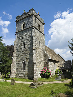
The parish church, known as Marija Širje, is dedicated to the Immaculate Conception and belongs to the Roman Catholic Diocese of Celje. It was originally a Romanesque building that was extended in 1747 and partially rebuilt in 1873. [6]

Parish church church which acts as the religious centre of a parish

A parish church in Christianity is the church which acts as the religious centre of a parish. In many parts of the world, especially in rural areas, the parish church may play a significant role in community activities, often allowing its premises to be used for non-religious community events. The church building reflects this status, and there is considerable variety in the size and style of parish churches. Many villages in Europe have churches that date back to the Middle Ages, but all periods of architecture are represented.

Immaculate Conception Catholic doctrine that Mary was conceived free from original sin

In Christian theology, the Immaculate Conception is the conception of the Virgin Mary free from original sin by virtue of the merits of her son Jesus. The Catholic Church teaches that God acted upon Mary in the first moment of her conception, keeping her "immaculate".

Roman Catholic Diocese of Celje diocese of the Catholic Church

The Roman Catholic Diocese of Celje is a diocese located in the city of Celje in the Ecclesiastical province of Maribor in Slovenia.

Related Research Articles

Hrastovec, Velenje Place in Styria, Slovenia

Hrastovec is a settlement in the Municipality of Velenje in northern Slovenia. The area was traditionally part of Styria. The municipality is now included in the Savinja Statistical Region.

Zadnja Vas in Upper Carniola, Slovenia

Zadnja Vas is a small village in the Municipality of Radovljica in the Upper Carniola region of Slovenia.

Brezje pri Tržiču Place in Upper Carniola, Slovenia

Brezje pri Tržiču is a settlement in the Municipality of Tržič in the Upper Carniola region of Slovenia. It is located near the road from Tržič to Begunje. In 2002 it had a population of 361.

Sveti Duh, Bloke in Inner Carniola, Slovenia

Sveti Duh is a small village north of Nova Vas in the Municipality of Bloke in the Inner Carniola region of Slovenia.

Kamence, Rogaška Slatina in Styria, Slovenia

Kamence is a settlement in the Municipality of Rogaška Slatina in eastern Slovenia, close to the border with Croatia. The area traditionally belonged to the region of Styria. It is now included in the Savinja Statistical Region.

Vidovica in Styria, Slovenia

Vidovica is a settlement in the Municipality of Podčetrtek in eastern Slovenia, close to the border with Croatia. The area was traditionally part of the Styria region. It is now included in the Savinja Statistical Region.

Vrhe, Trbovlje in Styria, Slovenia

Vrhe is a settlement in the Municipality of Trbovlje in central Slovenia. It lies in the hills northwest of the town of Trbovlje and part of the settlement lies in the neighbouring Municipality of Zagorje ob Savi. Traditionally the area was part of the Styria region. It is now included with the rest of the municipality in the Central Sava Statistical Region.

Gore, Hrastnik in Styria, Slovenia

Gore is a settlement in the Municipality of Hrastnik in central Slovenia. Traditionally the area was part of the Styria region. It is now included with the rest of the municipality in the Central Sava Statistical Region.

Turje, Hrastnik in Styria, Slovenia

Turje is a settlement in the hills southeast of Dol in the Municipality of Hrastnik in central Slovenia. Traditionally the area was part of the Styria region. It is now included with the rest of the municipality in the Central Sava Statistical Region.

Obrežje pri Zidanem Mostu Place in Styria, Slovenia

Obrežje pri Zidanem Mostu is a settlement in the Municipality of Laško in eastern Slovenia. It lies on the left bank of the Savinja River, close to its confluence with the Sava, opposite Zidani Most. The area was traditionally part of the Styria region. It is now included with the rest of the municipality in the Savinja Statistical Region.

Olešče in Styria, Slovenia

Olešče is a settlement in the Municipality of Laško in eastern Slovenia. It lies in the hills east of Laško. The area was traditionally part of the Styria region. It is now included with the rest of the municipality in the Savinja Statistical Region.

Šentrupert, Laško in Styria, Slovenia

Šentrupert is a settlement in the Municipality of Laško in eastern Slovenia. The area was traditionally part of the Styria region. It is now included with the rest of the municipality in the Savinja Statistical Region.

Jelovice in Styria, Slovenia

Jelovice is a settlement in the western Haloze Hills in the Municipality of Majšperk in northeastern Slovenia. The area is part of the traditional region of Styria. It is now included with the rest of the municipality in the Drava Statistical Region.

Brnica, Žalec in Styria, Slovenia

Brnica is a small settlement in hills on the right bank of the Savinja River in the Municipality of Žalec in east-central Slovenia. The area is part of the traditional region of Styria. The municipality is now included in the Savinja Statistical Region.

Čreta, Vransko in Styria, Slovenia

Čreta is a small settlement in the Municipality of Vransko in central Slovenia. It lies in the hills north of Vransko. The area is part of the traditional region of Styria. The municipality is now included in the Savinja Statistical Region.

Pečica in Styria, Slovenia

Pečica is a settlement in the Municipality of Šmarje pri Jelšah in eastern Slovenia. It lies in the hills north of Sladka Gora. The area is part of the historical Styria region. The municipality is now included in the Savinja Statistical Region.

Podgaj, Šentjur in Styria, Slovenia

Podgaj is a small settlement south of Ponikva in the Municipality of Šentjur in eastern Slovenia. Traditionally the area is part of Styria. The municipality is now included in the Savinja Statistical Region.

Šentvid pri Planini Place in Styria, Slovenia

Šentvid pri Planini is a village east of Planina pri Sevnici in the Municipality of Šentjur in eastern Slovenia. The area is part of the historical Styria region. The municipality is now included in the Savinja Statistical Region.
Vodule Place in Styria, Slovenia

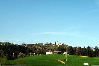
Vodule is a settlement in the Municipality of Šentjur in eastern Slovenia. It lies in the hills just east of Dramlje. The area is part of the historical Styria region. The municipality is now included in the Savinja Statistical Region.

Šentpavel na Dolenjskem Place in Lower Carniola, Slovenia

Šentpavel na Dolenjskem is a settlement just east of Šentvid pri Stični in the Municipality of Ivančna Gorica in central Slovenia. The area is part of the historical region of Lower Carniola. The municipality is now included in the Central Slovenia Statistical Region. It includes the hamlets of Grumlof, and Mandrga.

References

  1. Statistical Office of the Republic of Slovenia
  2. Laško municipal site
  3. Spremembe naselij 1948–95. 1996. Database. Ljubljana: Geografski inštitut ZRC SAZU, DZS.
  4. Premk, F. 2004. Slovenska versko-krščanska terminologija v zemljepisnih imenih in spremembe za čas 1921–1967/68. Besedoslovne lastnosti slovenskega jezika: slovenska zemljepisna imena. Ljubljana: Slavistično društvo Slovenije, pp. 113–132.
  5. Urbanc, Mimi & Matej Gabrovec. 2005. Krajevna imena: poligon za dokazovanje moči in odraz lokalne identitete. Geografski vestnik 77(2): 25–43.
  6. Slovenian Ministry of Culture register of national heritage reference number ešd 3155