Šuja

Last updated
Location of Zilina District in the Zilina Region Okres zilina.png
Location of Žilina District in the Zilina Region

Šuja is a village municipality in Žilina District in the Žilina Region of northern Slovakia.

Žilina District District in Žilina Region, Slovakia

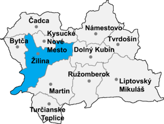
Žilina District is an okres (district) of the Žilina Region in north-western Slovakia. The district was first established in 1923. Its present borders date from 1996. The heart of the district is the Váh and Rajec river valleys. Urbanization has led to the district's becoming one of Slovakia's most highly developed areas.

Žilina Region Region in Slovakia

The Žilina Region is one of the eight Slovak administrative regions and consists of 11 districts (okresy) and 315 municipalities, from which 18 have a town status. The region was established in 1923, however, in its present borders exists from 1996. It is a more industrial region with several large towns. Žilina is the region administrative center and there is a strong cultural environment in Martin.

Slovakia republic in Central Europe

Slovakia, officially the Slovak Republic, is a landlocked country in Central Europe. It is bordered by Poland to the north, Ukraine to the east, Hungary to the south, Austria to the west, and the Czech Republic to the northwest. Slovakia's territory spans about 49,000 square kilometres (19,000 sq mi) and is mostly mountainous. The population is over 5.4 million and consists mostly of Slovaks. The capital and largest city is Bratislava, and the second largest city is Košice. The official language is Slovak.

Contents

History

The village was first mentioned in 1393.

Geography

Šuja lies at an elevation of 450 metres (1,480 ft) and covers an area of 2.424 km2 (0.936 sq mi). It has a population of about 318 people.

Elevation Height of a geographic location above a fixed reference point

The elevation of a geographic location is its height above or below a fixed reference point, most commonly a reference geoid, a mathematical model of the Earth's sea level as an equipotential gravitational surface . The term elevation is mainly used when referring to points on the Earth's surface, while altitude or geopotential height is used for points above the surface, such as an aircraft in flight or a spacecraft in orbit, and depth is used for points below the surface.

Related Research Articles

Visolaje Village in Trenčín Region, Slovakia

Visolaje is a village and municipality in the Púchov District, Trenčín Region of Slovakia. As of 2004, it had 947 inhabitants. The village lies near the major D1 motorway from Bratislava to Žilina

Beňadiková municipality of Slovakia

Beňadiková is a village and municipality in Liptovský Mikuláš District in the Žilina Region of northern Slovakia.

Podhorie, Žilina District municipality of Slovakia

Podhorie is a village and municipality in Žilina District in the Žilina Region of northern Slovakia.

Lysica municipality of Slovakia

Lysica is a village and municipality in Žilina District in the Žilina Region of northern Slovakia.

Nededza municipality of Slovakia

Nededza is a village and municipality in Žilina District in the Žilina Region of northern Slovakia.

Dolný Hričov municipality of Slovakia

Dolný Hričov is a village and municipality in Žilina District in the Žilina Region of northern Slovakia.

Jasenové municipality of Slovakia

Jasenové is a village and municipality in Žilina District in the Žilina Region of northern Slovakia.

Paština Závada municipality of Slovakia

Paština Závada is a village and municipality in Žilina District in the Žilina Region of northern Slovakia.

Lietavská Lúčka municipality of Slovakia

Lietavská Lúčka is a village and municipality in Žilina District in the Žilina Region of northern Slovakia.

Dlhé Pole municipality of Slovakia

Dlhé Pole is a village and municipality in Žilina District in the Žilina Region of northern Slovakia.

Lutiše municipality of Slovakia

Lutiše is a village and municipality in Žilina District in the Žilina Region of northern Slovakia.

Ďurčiná municipality of Slovakia

Ďurčiná is a village and municipality in Žilina District in the Žilina Region of northern Slovakia.

Mojš municipality of Slovakia

Mojš is a village and municipality in Žilina District in the Žilina Region of northern Slovakia.

Partizánska Ľupča municipality of Slovakia

Partizánska Ľupča is a large village and municipality in Liptovský Mikuláš District in the Žilina Region of northern Slovakia.

Galovany municipality of Slovakia

Galovany is a village and municipality in Liptovský Mikuláš District in the Žilina Region of northern Slovakia. The village merged with the former Velika Paludza village in the 19th century.

Gôtovany municipality of Slovakia

Gôtovany is a village and municipality in Liptovský Mikuláš District in the Žilina Region of northern Slovakia.

Závažná Poruba municipality of Slovakia

Závažná Poruba is a village and municipality in Liptovský Mikuláš District in the Žilina Region of northern Slovakia.

Uhorská Ves municipality of Slovakia

Uhorská Ves is a village and municipality in Liptovský Mikuláš District in the Žilina Region of northern Slovakia.

Chandu Suja is a village in Batala in Gurdaspur district of Punjab State, India. The village is administrated by Sarpanch an elected representative of the village.

References

    Coordinates: 49°04′N18°38′E / 49.067°N 18.633°E / 49.067; 18.633

    Geographic coordinate system Coordinate system

    A geographic coordinate system is a coordinate system that enables every location on Earth to be specified by a set of numbers, letters or symbols. The coordinates are often chosen such that one of the numbers represents a vertical position and two or three of the numbers represent a horizontal position; alternatively, a geographic position may be expressed in a combined three-dimensional Cartesian vector. A common choice of coordinates is latitude, longitude and elevation. To specify a location on a plane requires a map projection.