Bonarówka is a village in the administrative district of Gmina Strzyżów, within Strzyżów County, Subcarpathian Voivodeship, in south-eastern Poland. It lies approximately 8 kilometres (5 mi) south of Strzyżów and 29 km (18 mi) south-west of the regional capital Rzeszów.

Brzeżanka is a village in the administrative district of Gmina Strzyżów, within Strzyżów County, Subcarpathian Voivodeship, in south-eastern Poland. It lies approximately 5 kilometres (3 mi) south of Strzyżów and 28 km (17 mi) south-west of the regional capital Rzeszów.
Dobrzechów is a village in the administrative district of Gmina Strzyżów, within Strzyżów County, Subcarpathian Voivodeship, in south-eastern Poland. It lies approximately 3 kilometres (2 mi) west of Strzyżów and 25 km (16 mi) south-west of the regional
Gbiska is a village in the administrative district of Gmina Strzyżów, within Strzyżów County, Podkarpackie Voivodeship, in south-eastern Poland.
Glinik Charzewski is a village in the administrative district of Gmina Strzyżów, within Strzyżów County, Subcarpathian Voivodeship, in south-eastern Poland. It lies approximately 6 kilometres (4 mi) north-east of Strzyżów and 18 km (11 mi) south-west of the regional capital Rzeszów.
Glinik Zaborowski is a village in the administrative district of Gmina Strzyżów, within Strzyżów County, Subcarpathian Voivodeship, in south-eastern Poland. It lies approximately 4 kilometres (2 mi) north-east of Strzyżów and 20 km (12 mi) south-west of the regional capital Rzeszów.
Godowa is a village in the administrative district of Gmina Strzyżów, within Strzyżów County, Subcarpathian Voivodeship, in south-eastern Poland. It lies approximately 4 kilometres (2 mi) south of Strzyżów and 25 km (16 mi) south-west of the regional capital Rzeszów.
Grodzisko is a village in the administrative district of Gmina Strzyżów, within Strzyżów County, Subcarpathian Voivodeship, in south-eastern Poland. It lies approximately 7 kilometres (4 mi) north-west of Strzyżów and 25 km (16 mi) south-west of the regional capital Rzeszów.
Łętownia is a village in the administrative district of Gmina Strzyżów, within Strzyżów County, Podkarpackie Voivodeship, in south-eastern Poland.
Tropie is a village in the administrative district of Gmina Strzyżów, within Strzyżów County, Subcarpathian Voivodeship, in south-eastern Poland. It lies approximately 4 kilometres (2 mi) north of Strzyżów and 22 km (14 mi) south-west of the regional capital Rzeszów.
Wysoka Strzyżowska is a village in the administrative district of Gmina Strzyżów, within Strzyżów County, Subcarpathian Voivodeship, in south-eastern Poland. It lies approximately 7 kilometres (4 mi) south-west of Strzyżów and 29 km (18 mi) south-west of the regional capital Rzeszów.
Zawadka is a village in the administrative district of Gmina Strzyżów, within Strzyżów County, Subcarpathian Voivodeship, in south-eastern Poland. It lies approximately 9 kilometres (6 mi) north-west of Strzyżów and 25 km (16 mi) south-west of the regional capital Rzeszów.
Żyznów is a village in the administrative district of Gmina Strzyżów, within Strzyżów County, Subcarpathian Voivodeship, in south-eastern Poland. It lies approximately 9 kilometres (6 mi) south-east of Strzyżów and 27 km (17 mi) south-west of the regional capital Rzeszów.
Babica is a village in the administrative district of Gmina Czudec, within Strzyżów County, Subcarpathian Voivodeship, in south-eastern Poland. It lies approximately 5 kilometres (3 mi) east of Czudec, 11 km (7 mi) north-east of Strzyżów, and 14 km (9 mi) south-west of the regional capital Rzeszów.
Cieszyna is a village in the administrative district of Gmina Frysztak, within Strzyżów County, Subcarpathian Voivodeship, in south-eastern Poland. It lies approximately 6 kilometres (4 mi) north of Frysztak, 14 km (9 mi) west of Strzyżów, and 34 km (21 mi) south-west of the regional capital Rzeszów.
Lubla is a village in the administrative district of Gmina Frysztak, within Strzyżów County, Subcarpathian Voivodeship, in south-eastern Poland. It lies approximately 4 kilometres (2 mi) south-west of Frysztak, 17 km (11 mi) south-west of Strzyżów, and 39 km (24 mi) south-west of the regional capital Rzeszów.
Konieczkowa is a village in the administrative district of Gmina Niebylec, within Strzyżów County, Subcarpathian Voivodeship, in south-eastern Poland. It lies approximately 3 kilometres (2 mi) east of Niebylec, 12 km (7 mi) east of Strzyżów, and 22 km (14 mi) south of the regional capital Rzeszów.
Pstrągówka is a village in the administrative district of Gmina Wiśniowa, within Strzyżów County, Subcarpathian Voivodeship, in south-eastern Poland. It lies approximately 12 kilometres (7 mi) west of Strzyżów and 33 km (21 mi) south-west of the regional capital Rzeszów.
Wiśniowa is a village in Strzyżów County, Subcarpathian Voivodeship, in south-eastern Poland. It is the seat of the gmina called Gmina Wiśniowa. It lies approximately 11 kilometres (7 mi) west of Strzyżów and 33 km (21 mi) south-west of the regional capital Rzeszów.
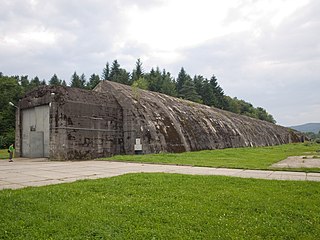
Anlage Süd was a pair of railway headquarters built for Adolf Hitler in the Nazi-occupied part of southern Poland during the Second World War. Two reinforced tunnels were built near the rail line between Rzeszów and Jasło. The first massive train bunker was located in the village of Stępina, and the other was in the town of Strzyżów. They were initially used for a two-day meeting between Hitler and Italian fascist leader Benito Mussolini, on 27–28 August 1941.


