
Parham Airfield Museum is a museum in Framlingham in Suffolk, England. The airfield was named after the village of Parham in Suffolk famously linked to the Aldeburgh poet George Crabbe.
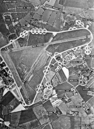
Royal Air Force Chelveston or more simply RAF Chelveston is a former Royal Air Force station located on the south side of the B645, 5 miles (8.0 km) east of Wellingborough, near the village of Chelveston in Northamptonshire, England. During the Second World War the airfield was occupied by both the Royal Air Force and the United States Army Air Forces. It was given the USAAF designation Station 105.
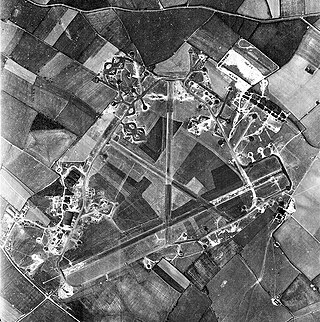
Royal Air Force Raydon or more simply RAF Raydon is a former Royal Air Force station located just to the northeast of the village of Raydon, about 6 miles (9.7 km) from Ipswich, England.

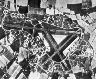
Royal Air Force Podington, more commonly known as RAF Podington, is a former Royal Air Force (RAF) station in northern Bedfordshire, England, 6 miles south-east of Wellingborough, Northamptonshire.

Royal Air Force Horsham St Faith or more simply RAF Horsham St Faith is a former Royal Air Force station near Norwich, Norfolk, England which was operational from 1939 to 1963. It was then developed as Norwich International Airport.

Thorpe Abbotts is a village and a former civil parish, now in the parish of Brockdish, in the South Norfolk district, in the county of Norfolk, England. The village is 6.5 miles (10.5 km) east of Diss, 20.8 miles (33.5 km) south south west of Norwich and 106 miles (171 km) north east of London. The village lies .4 miles (0.64 km) north of the A143 Diss to Great Yarmouth road. The nearest railway station is at Diss for the Great Eastern Main Line which runs between Norwich and Liverpool Street station, London. The nearest airport is Norwich International Airport. In 1931 the parish had a population of 170.

Royal Air Force Ridgewell or more simply RAF Ridgewell is a former Royal Air Force station located at Ridgewell, 7.5 miles (12.1 km) north west of Halstead, Essex, England.

Royal Air Force Bodney or more simply RAF Bodney is a former Royal Air Force Station located 4.5 miles (7.2 km) west of Watton, Norfolk, England.

Royal Air Force Tibenham or more simply RAF Tibenham is a former Royal Air Force station located 13.5 miles (21.7 km) southwest of Norwich and 5.8 miles (9.3 km) north of Diss, Norfolk, England.

Royal Air Force Old Buckenham or more simply RAF Old Buckenham is a former Royal Air Force station located 2 miles (3.2 km) south east of Attleborough, Norfolk, England which was used during the Second World War by the United States for the strategic bombing campaign against Germany.

Royal Air Force Eye or more simply RAF Eye is a former Royal Air Force station located 11 miles (18 km) northeast of Stowmarket, Suffolk, England on the northwest edge of Eye and south of Diss.

Royal Air Force Bungay or more simply RAF Bungay is a former Royal Air Force station located 3 miles (4.8 km) south-west of Bungay in the English county of Suffolk.

Royal Air Force Seething, or more simply RAF Seething , is a former Royal Air Force station located around 9 NM south-east of Norwich, Norfolk, England. The base was located on the parish boundaries of Seething, Mundham and Hedenham.

Royal Air Force Halesworth or more simply RAF Halesworth is a former Royal Air Force station located 2 miles (3 km) north east of the town of Halesworth, Suffolk, England and 7 miles (11 km) west of Southwold.

Royal Air Force Rackheath, more commonly known as RAF Rackheath, is a former Royal Air Force station located near the village of Rackheath, approximately 6 miles north-east of Norwich, in the county of Norfolk in England.
Royal Air Force Attlebridge, or simply RAF Attlebridge, is a former Royal Air Force station located near Attlebridge and 8 miles (13 km) northwest of Norwich, Norfolk, England.

Royal Air Force Thorpe Abbotts or more simply RAF Thorpe Abbotts is a former Royal Air Force station located 4 miles (6.4 km) east of Diss, Norfolk, England.

Royal Air Force Boxted or more simply RAF Boxted is a former Royal Air Force station located 4 miles (6.4 km) north-northeast of Colchester, Essex England.

Thwaite St Mary is a rural village in the English county of Norfolk, it sits just a few miles north of the Suffolk border. Thwaite – sometimes pronounced ‘twayt’ by locals – has approximately thirty-five dwellings and a population of around seventy-nine. The population is included in the civil parish of Hedenham.


