Love Canal is a neighborhood in Niagara Falls, New York, United States, infamous as the location of a 0.28 km2 (0.11 sq mi) landfill that became the site of an enormous environmental disaster in the 1970s. Decades of dumping toxic chemicals harmed the health of hundreds of residents; the area was cleaned up over the course of 21 years in a Superfund operation.

Olin Corporation is an American manufacturer of ammunition, chlorine, and sodium hydroxide. The company traces its roots to two companies, both founded in 1892: Franklin W. Olin's Equitable Powder Company and the Mathieson Alkali Works. Accidents at Olin chemical plants have exposed employees and nearby residents to health hazards.

The Agriculture Street Landfill was a dump located in the Desire Area of New Orleans, Louisiana. The area was later developed for residential use, with unfortunate environmental consequences. It became a Superfund cleanup site in 1994.
VOCs are a dangerous contaminant of groundwater, leading to groundwater pollution. They are generally introduced to the environment through careless industrial practices.

The former Lake Ontario Ordnance Works (LOOW) was a 7,500-acre (3,000 ha) military installation located in Niagara County, New York, United States, approximately 9.6 mi (15.4 km) north of Niagara Falls.
The 120-acre (0.49 km2) Pfohl Brothers Landfill was a privately owned and operated landfill in Cheektowaga, New York. The landfill accepted municipal and industrial wastes from 1932 until 1971. It is located 1/2 mile east of the Buffalo Niagara International Airport and sits on the north bank of Ellicott Creek. It lies west of Transit Road and south of the New York State Thruway near Thruway Exit 49. It is bisected by Aero Drive.
The Hercules 009 Landfill Superfund site is a 16.5-acre (67,000 m2) property that is bordered by Georgia State Route 25 on the west; an automobile dealership on the north; a juvenile slash pine forest on the east; and several homes, a church, a school, and a strip shopping center to the south/southeast of the property. Hercules Inc. was issued a permit in 1975 by the GaEPD to use 7 acres (28,000 m2) at the northern end of the property as a landfill to dispose of toxaphene-contaminated wastewater sludge generated during the manufacturing processes. The 009 Landfill was constructed at the northern end of the property as six cells, each approximately 100 to 200 feet (61 m) wide and 400 feet (120 m) long. Toxaphene has been detected at levels exceeding 15,000 parts per million at the Hercules 009 Landfill Site.
The Laurel Park, Inc. site, also known as Hunters Mountain Dump, or Murtha's Dump to locals, is a capped landfill that occupies approximately 20 acres (81,000 m2) of a 35-acre (140,000 m2) parcel of land in Naugatuck, Connecticut. The landfill has been in existence since the late 1940s, and several industries disposed of solvents, oils, hydrocarbons, chemical and liquid sludge, chemical solids, tires, and rubber products there. The facility continued to operate as a municipal landfill until 1987. It was owned and operated by Terrence and Howard Murtha.
Havertown Superfund is a 13-acre polluted groundwater site in Havertown, Pennsylvania contaminated by the dumping of industrial waste by National Wood Preservers from 1947 to 1991. The state first became aware of the pollution in 1962 and initiated legal action against the owners in 1973 to force them to cleanup the site. The Environmental Protection Agency (EPA) ranked the site the eighth worst cleanup project in the United States. The site was added to the National Priorities List in 1983 and designated as a Superfund cleanup site in the early 1990s. Remediation and monitoring efforts are ongoing and the EPA transferred control of the site to the Pennsylvania Department of Environmental Protection in 2013.
The Killing Ground is a 1979 American documentary film written by Brit Hume. The film portrays environmental and human health effects of toxic waste dump-sites in Niagara Falls, New York and other locations. It was nominated for an Academy Award for Best Documentary Feature.

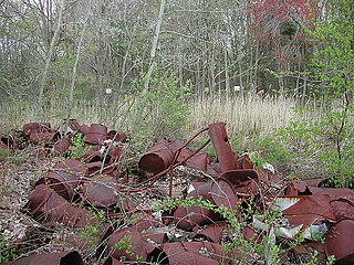
The Valley of the Drums is a 23-acre toxic waste site near Brooks in northern Bullitt County, Kentucky, near Louisville, named after the waste-containing drums strewn across the area. After it had been collecting waste since the 1960s, the United States Environmental Protection Agency (EPA) analyzed the property and creek in 1979, finding high levels of heavy metals, polychlorinated biphenyls, and some 140 other chemical substances. It is known as one of the primary motivations for the passage of the Comprehensive Environmental Response, Compensation, and Liability Act, or Superfund Act of 1980. While the widely publicized Love Canal disaster is often credited as the reason the Superfund law was passed, Love Canal activist Lois Gibbs has said that Love Canal looked like a suburban community, while "Valley of the Drums became the visualization of the problem." Officially, cleanup began at the site in 1983 and ended in 1990, though later problems have been reported and investigated.
The Ringwood Mines landfill site is a 500-acre former iron mining site located in the borough of Ringwood, New Jersey. Used in the late 1960s and early 1970s by the large Ford Motor Company plant in nearby Mahwah, New Jersey for disposal of waste, it was identified by the Environmental Protection Agency (EPA) for its Superfund priority list in 1984 for cleanup of hazardous wastes. EPA deleted the site from the Superfund list in 1994 but subsequently relisted the site several times due to failed environmental remediation. Portions of the landfill site were repurposed as land used for affordable housing for the Ramapough people in the 1970s, even though the land was contaminated.
Shpack Landfill is a hazardous waste site in Norton, Massachusetts. After assessment by the United States Environmental Protection Agency (EPA) it was added to the National Priorities List in October 1986 for long-term remedial action. The site cleanup is directed by the federal Superfund program. The Superfund site covers 9.4 acres, mostly within Norton, with 3.4 acres in the adjoining city of Attleboro. The Norton site was operated as a landfill dump accepting domestic and industrial wastes, including low-level radioactive waste, between 1946 and 1965. The source of most of the radioactive waste, consisting of uranium and radium, was Metals and Controls Inc. which made enriched uranium fuel elements for the U.S. Navy under contract with the U.S. Atomic Energy Commission. Metals and Controls merged with Texas Instruments in 1959. The Shpack landfill operation was shut down by a court order in 1965.
Hooker Chemical Company was an American firm producing chloralkali products from 1903 to 1968. In 1922, bought the S. Wander & Sons Company to sell lye and chlorinated lime. The company became notorious in 1977, when residents near its chemical waste site, Love Canal, reported extraordinarily high incidences of leukemia, birth defects, and other injuries. Although Hooker had sold its old chemical waste dump site to the Niagara Falls School Board in 1953, the company was held responsible as a result of a lawsuit thereafter.
The Dewey Loeffel Landfill is an EPA superfund site located in Rensselaer County, New York. In the 1950s and 1960s, several companies including General Electric, Bendix Corporation and Schenectady Chemicals used the site as a disposal facility for more than 46,000 tons of industrial hazardous wastes, including solvents, waste oils, polychlorinated biphenyls (PCBs), scrap materials, sludges and solids. Some hazardous substances, including volatile organic compounds (VOCs) and PCBs, have migrated from the facility to underlying aquifers and downstream surface water bodies, resulting in contamination of groundwater, surface water, sediments and several species of fish. There is currently a ban on fish consumption in Nassau Lake and the impacted tributaries. Site investigations are underway to determine the nature and extent of the contamination and inform the development of permanent cleanup options for the site.
Emmell's Septic Landfill (ESL) is located at 128 Zurich Ave, Galloway Township, New Jersey and takes up about 38 acres of space. The landfill was in operation from 1967 until 1979. ESL disposed of liquid and solid waste including many chemicals such as volatile organic compounds (VOCs), Polychlorinated Biphenyls (PCBs), Trichloroethene and Vinyl chloride which all had their own effect on the environment and community. These chemicals affected the groundwater required millions of dollars to reconstruct the groundwater pathways and provide clean water to residents. The landfill holds a Hazardous Ranking Score of a 50/100, qualifying for the Superfund National Priority List. In August 1999, the state acknowledged the site's contamination and held town meetings and provided research upon the site such as groundwater samples. In July 1997, a sitewide investigation was called upon by the United States Environmental Protection Agency. In total the clean up was estimated to cost $5 million to fund this superfund site, and a grant of $3.9 million was given by the Federal Government under the Recovery Act Funding (Previti). Today, the project is still ongoing however, greatly improved since the landfill was discovered.
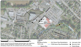
Price Landfill is a 26-acre site located in Pleasantville, Egg Harbor Township, Atlantic County, New Jersey. Price Landfill is also known as Price Sanitary Landfill, Prices Pit, Price Landfill No.1 and Price Chemical Dump. The United States Environmental Protection Agency (USEPA) added Price Landfill to the Superfund National Priorities List on September 20, 1983 because of the hazardous chemicals found on the site and in the groundwater. The site was originally owned by Mr. Charles Price and was used to mine sand and gravel, which was shut down in 1968. The site was then turned into a private landfill in 1969 and then a commercial solid waste landfill in 1971. At this point the landfill was used to dispose of liquid waste by companies, specifically Atlantic City Electric Company. The liquid waste consisted of industrial chemicals, oils and greases/sludges, septic tank and sewer wastes, which were disposed on the site for 8 years, ending altogether in 1976, but in the meantime, having contaminated the groundwater, soil, air, and nearby creeks, specifically Absecon Creek. Chemicals dumped on the site are believed to be 1,2-Dichloroethane, arsenic, benzene, chloroform, lead, and vinyl chloride, all of which contaminated the groundwater, soil, air, and nearby creeks. The USEPA originally got involved in 1982 by beginning to correct the damage. Currently the USEPA states that they are continuing to monitor and treat the groundwater and land, and that hazards to humans are controlled.
The Burnt Fly Bog Superfund Site is located in Marlboro Township in Monmouth County, New Jersey. Contamination began in the 1950s and 1960s. It was used as a dumping ground for hazardous chemicals and oils. This site was used to reprocess or recycle oil, and it was also used as a landfill during the 1950s. The contamination affected the surface water and soil. The EPA got involved in the 1980s and addressed the situation. Human health concerns were a main part of the EPA getting involved because residents lived only about 1,000 to 2,000 feet around the site. Major components of the remedy included excavation and off-site disposal of contaminated soil from Northerly Wetlands, Tar Patch Area. The back filling of the areas addressed, monitoring of the surface water and sediments, and biological sampling in the Westerly Wetlands. The current status of the site is complete. The remedial stages were completed in the late 1990s and a five-year monitoring of the surface water was completed around 2004.