This article needs additional citations for verification .(February 2024) |
The 1610s BC was a decade lasting from January 1, 1619 BC to December 31, 1610 BC.
Contents
| Millennium |
|---|
| 2nd millennium BC |
| Centuries |
| Decades |
| Years |
|
| Categories |
This article needs additional citations for verification .(February 2024) |
The 1610s BC was a decade lasting from January 1, 1619 BC to December 31, 1610 BC.
| Millennium |
|---|
| 2nd millennium BC |
| Centuries |
| Decades |
| Years |
|
| Categories |
A caldera is a large cauldron-like hollow that forms shortly after the emptying of a magma chamber in a volcanic eruption. An eruption that ejects large volumes of magma over a short period of time can cause significant detriment to the structural integrity of such a chamber, greatly diminishing its capacity to support its own roof, and any substrate or rock resting above. The ground surface then collapses into the emptied or partially emptied magma chamber, leaving a large depression at the surface. Although sometimes described as a crater, the feature is actually a type of sinkhole, as it is formed through subsidence and collapse rather than an explosion or impact. Compared to the thousands of volcanic eruptions that occur over the course of a century, the formation of a caldera is a rare event, occurring only a few times within a given window of 100 years. Only eight caldera-forming collapses are known to have occurred between 1911 and 2018, with a caldera collapse at Kīlauea, Hawaii in 2018. Volcanoes that have formed a caldera are sometimes described as "caldera volcanoes".
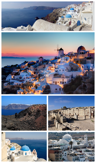
Santorini, officially Thira or Thera, is a Greek island in the southern Aegean Sea, about 200 km (120 mi) southeast from its mainland. It is the largest island of a small, circular archipelago formed by the Santorini caldera. It is the southernmost member of the Cyclades group of islands, with an area of approximately 73 km2 (28 sq mi) and a 2021 census population of 15,480. The municipality of Santorini includes the inhabited islands of Santorini and Therasia, as well as the uninhabited islands of Nea Kameni, Palaia Kameni, Aspronisi and Christiana. The total land area is 90.623 km2 (34.990 sq mi). Santorini is part of the Thira regional unit.

A volcano is a rupture in the crust of a planetary-mass object, such as Earth, that allows hot lava, volcanic ash, and gases to escape from a magma chamber below the surface. The process that forms volcanoes is called volcanism.

Mount Vesuvius is a somma–stratovolcano located on the Gulf of Naples in Campania, Italy, about 9 km (5.6 mi) east of Naples and a short distance from the shore. It is one of several volcanoes forming the Campanian volcanic arc. Vesuvius consists of a large cone partially encircled by the steep rim of a summit caldera, resulting from the collapse of an earlier, much higher structure.

The year 1816 AD is known as the Year Without a Summer because of severe climate abnormalities that caused average global temperatures to decrease by 0.4–0.7 °C (0.7–1 °F). Summer temperatures in Europe were the coldest of any on record between 1766 and 2000, resulting in crop failures and major food shortages across the Northern Hemisphere.

Mount Tambora, or Tomboro, is an active stratovolcano in West Nusa Tenggara, Indonesia. Located on Sumbawa in the Lesser Sunda Islands, it was formed by the active subduction zones beneath it. Before 1815, its elevation reached more than 4,300 metres high, making it one of the tallest peaks in the Indonesian archipelago.

Iwo Jima, officially romanized and pronounced Iōtō, is one of the Japanese Volcano Islands, which lie south of the Bonin Islands and together with them make up the Ogasawara Archipelago. Together with the Izu Islands, they make up Japan's Nanpō Islands. Although 1,200 km (750 mi) south of Tokyo on Honshu, Iwo Jima is administered as part of the Ogasawara Subprefecture of the Tokyo Metropolitan Government.

The Ring of Fire is a tectonic belt of volcanoes and earthquakes.

The volcanic winter of 536 was the most severe and protracted episode of climatic cooling in the Northern Hemisphere in the last 2,000 years. The volcanic winter was caused by at least three simultaneous eruptions of uncertain origin, with several possible locations proposed in various continents. Most contemporary accounts of the volcanic winter are from authors in Constantinople, the capital of the Eastern Roman Empire, although the impact of the cooler temperatures extended beyond Europe. Modern scholarship has determined that in early AD 536, an eruption ejected massive amounts of sulfate aerosols into the atmosphere, which reduced the solar radiation reaching the Earth's surface and cooled the atmosphere for several years. In March 536, Constantinople began experiencing darkened skies and lower temperatures.

Nevado del Ruiz, also known as La Mesa de Herveo is a volcano on the border of the departments of Caldas and Tolima in Colombia, being the highest point of both. It is located about 130 km (81 mi) west of the capital city Bogotá. It is a stratovolcano composed of many layers of lava alternating with hardened volcanic ash and other pyroclastic rocks. Volcanic activity at Nevado del Ruiz began about two million years ago, during the Early Pleistocene or Late Pliocene, with three major eruptive periods. The current volcanic cone formed during the present eruptive period, which began 150,000 years ago.

Kīlauea is an active shield volcano in the Hawaiian Islands. It is located along the southeastern shore of Hawaii Island. The volcano is between 210,000 and 280,000 years old and grew above sea level about 100,000 years ago. Since the islands were settled, it has been the most active of the five volcanoes that together form the island and among the most active volcanoes on Earth. The most recent eruption occurred on June 3, 2024, along fissures that opened on the volcano's southwest rift zone.

The volcanism of Italy is due chiefly to the presence, a short distance to the south, of the boundary between the Eurasian Plate and the African Plate. Italy is a volcanically active country, containing the only active volcanoes in mainland Europe. The lava erupted by Italy's volcanoes is thought to result from the subduction and melting of one plate below another.

Grindavík is a fishing town in the Southern Peninsula district of Iceland, not far from Þorbjörn, a tuya.

The Soufrière Hills are an active, complex stratovolcano with many lava domes forming its summit on the Caribbean island of Montserrat. After a long period of dormancy, the Soufrière Hills volcano became active in 1995 and continued to erupt through 2010. Its last eruption was in 2013. Its eruptions have rendered more than half of Montserrat uninhabitable, destroying the capital city, Plymouth, and causing widespread evacuations: about two-thirds of the population have left the island. Chances Peak in the Soufrière Hills was the highest summit on Montserrat until the mid-1990s, but it has since been eclipsed by various rising and falling volcanic domes during the recent volcanic activity.

Taal Volcano is a large caldera filled by Taal Lake in the Philippines. Located in the province of Batangas about 50 kilometers (31 mi) south of Manila, the volcano is the second most active volcano in the country with 38 recorded historical eruptions, all of which were concentrated on Volcano Island, near the middle of Taal Lake. The caldera was formed by prehistoric eruptions between 140,000 and 5,380 BP.
Jeju Island is South Korea's largest island, covering an area of 1,833.2 km2 (707.8 sq mi), which is 1.83% of the total area of the country. Alongside outlying islands, it is part of Jeju Province and makes up the majority of the Province.

The Minoan eruption was a catastrophic volcanic eruption that devastated the Aegean island of Thera circa 1600 BCE. It destroyed the Minoan settlement at Akrotiri, as well as communities and agricultural areas on nearby islands and the coast of Crete with subsequent earthquakes and paleotsunamis. With a Volcanic Explosivity Index (VEI) of 6, it resulted in the ejection of approximately 28–41 km3 (6.7–9.8 cu mi) of dense-rock equivalent (DRE), the eruption was one of the largest volcanic events in human history. Since tephra from the Minoan eruption serves as a marker horizon in nearly all archaeological sites in the Eastern Mediterranean, its precise date is of high importance and has been fiercely debated among archaeologists and volcanologists for decades, without coming to a definite conclusion.

Mount Price is a small stratovolcano in the Garibaldi Ranges of the Pacific Ranges in southwestern British Columbia, Canada. It has an elevation of 2,049 metres and rises above the surrounding landscape on the western side of Garibaldi Lake in New Westminster Land District. The mountain contains a number of subfeatures, including Clinker Peak on its western flank, which was the source of two thick lava flows between 15,000 and 8,000 years ago that ponded against glacial ice. These lava flows are structurally unstable, having produced large landslides as recently as the 1850s. A large provincial park surrounds Mount Price and other volcanoes in its vicinity. It lies within an ecological region that surrounds much of the Pacific Ranges.
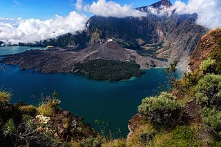
In 1257, a catastrophic eruption occurred at Samalas, a volcano on the Indonesian island of Lombok. The event had a probable Volcanic Explosivity Index of 7, making it one of the largest volcanic eruptions during the Holocene epoch. It left behind a large caldera that contains Lake Segara Anak. Later volcanic activity created more volcanic centres in the caldera, including the Barujari cone, which remains active.
| | This BC year article is a stub. You can help Wikipedia by expanding it. |