
Kastellet is a citadel located in Copenhagen, Denmark. It is one of the best preserved fortresses in Northern Europe. It is constructed in the form of a pentagon with bastions at its corners. Kastellet was continuous with the ring of bastioned ramparts which used to encircle Copenhagen but of which only the ramparts of Christianshavn remain today.

Indre By, also known as Copenhagen Center or K or Downtown Copenhagen, is an administrative district (bydel) in central Copenhagen, the capital of Denmark. It covers an area of 4.65 square kilometres (1.80 sq mi), has a population of 26,223, and a population density of 5,638 per km2.

Caspar Frederik (Friedrich) Harsdorff, also known as C.F. Harsdorff, was a Danish neoclassical architect considered to have been the leading Danish architect in the late 18th century.

Kongens Nytorv is a public square in Copenhagen, Denmark, centrally located at the end of the pedestrian street Strøget. The largest square of the city, it was laid out by Christian V in 1670 in connection with a major extension of the fortified city, and has an equestrian statue of him at its centre. The initiative moved the centre of the city from the medieval area around Gammeltorv, at that time a muddy medieval marketplace, to a cobbled new square with a garden complex, inspired by the Royal city planning seen in Paris from the early 17th century.
Elias David Häusser was a German-Danish architect working in the Baroque and Rococo styles. He is most known for designing the first Christiansborg Palace which was almost completely destroyed in a fire in 1794. Häusser is credited with introducing both those styles to Denmark.

Charlottenborg Palace is a large town mansion located on the corner of Kongens Nytorv and Nyhavn in Copenhagen, Denmark. Originally built as a residence for Ulrik Frederik Gyldenløve, it has served as the base of the Royal Danish Academy of Fine Arts since its foundation in 1754. Today it also houses Kunsthal Charlottenborg, an institution for contemporary art, and Danmarks Kunstbibliotek, the Royal Art Library.

The fortifications of Copenhagen underwent a comprehensive modernization and expansion in the 17th century. The project was commenced and was largely the masterplan of Christian IV in the early 17th century but was continued and completed by his successors. The new fortifications relied on the existing, medieval fortifications of the city but the fortified area was extended and a defensive ring around the city completed particularly with new edifices facing the sea. The ring fortification consisted of four bastioned ramparts and an annexed citadel as well as various outworks.
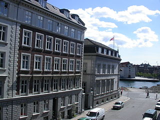
Gammelholm is a predominantly residential neighbourhood in the city centre of Copenhagen, Denmark. It is bounded by the Nyhavn canal, Kongens Nytorv, Holmens Kanal, Niels Juels Gade and the waterfront along Havnegade. For centuries, the area was the site of the Royal Naval Shipyard, known as Bremerholm, but after the naval activities relocated to Nyholm, it came under residential redevelopment in the 1860s and 1870s. The new neighbourhood was planned by Ferdinand Meldahl and has also been referred to as "Meldahl's Nine Streets". Apart from the buildings which face Kongens Nytorv, which include the Royal Danish Theatre and Charlottenborg Palace, the area is characterized by homogeneous Historicist architecture consisting of perimeter blocks with richly decorated house fronts.
Christianshavns Vold is a former rampart which was part of the bastioned fortification ring which used to surround Copenhagen, Denmark. Running along the full south-eastern perimeter of Christianshavn and Holmen, it used to form a protective barrier towards the island of Amager. It consists of earthworks with 12 bastions and in front of it ran a moat, Stadsgraven, now forming a broad canal which separates Christianshavn from the rest of Amager. On the other side of Stadsgraven. on Amager, was a lower system of outworks called Christianshavns Enveloppe of which only the northern half survives. Along with Kastellet on the other side of the harbour, it is the only intact part of the fortification system.
Den Danske Vitruvius is a richly illustrated 18th-century architectural work on Danish monumental buildings of the period, written by the Danish Baroque architect Lauritz de Thurah. It was commissioned by Christian VI in 1735 and published in two volumes between 1746 and 1749. The title refers to the Roman architect and engineer Vitruvius, who published De architectura in the 1st century AD, an authoritative treatise on the architecture of the time. The direct inspiration for de Thurah's Den Danske Vitruvius was Colen Campbell's Vitruvius Britannicus.

Hafnia Hodierna, Eller Udførlig Beskrivelse om den Kongelige Residentz- og Hoved-Stad Kiøbenhavn is an engraved architectural work on Copenhagen, published by the Danish architect Lauritz de Thurah in 1748. Profusely illustrated throughout, it is a valuable source of knowledge as to the appearance of Copenhagen in the middle of the 18th century. It complements, with some overlap, de Thurah's other major work Den Danske Vitruvius, which focuses primarily on surrounding areas, as well as the rest of Denmark.
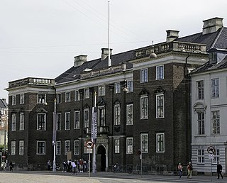
Ewert Janssen or Evert Janssen was a Danish architect who became a royal masterbuilder in 1668. His greatest achievement was Charlottenborg Palace in Copenhagen.

Gothersgade is a major street in the City Centre of Copenhagen, Denmark. It extends from Kongens Nytorv to Sortedam Lake, passing Rosenborg Castle and Gardens, Nørreport Station and Copenhagen Botanic Gardens on the way.
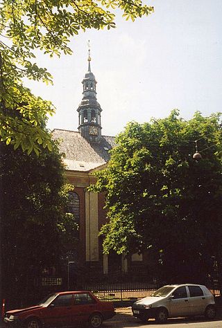
Reformed Church in Gothersgade, opposite Rosenborg Castle, is a church building used by the reformed congregations in Copenhagen, Denmark. Consecrated in 1689, the church was instigated by Queen Charlotte Amalie, consort of King Christian V, who was herself a German Calvinist. The church is noted for its fine Baroque interiors which date from 1730 when it was restored after being damaged in the Copenhagen Fire of 1728.
Events from the year 1724 in Denmark.

The Moltke's Mansion is a town mansion on the corner of Bredgade and Dronningens Tværgade in Copenhagen, Denmark. It is one of several town mansions in Frederiksstaden, although it actually predates the neighbourhood by half a century. It was built for Ulrik Frederik Gyldenløve between 1700 and 1702 and was originally known as Gyldenløve's Little Mansion. It received its current name in 1842, after it was acquired by Adam Wilhelm Moltke, the first Danish Prime Minister under the Danish constitutional monarchy.

The Thott Mansion is a listed town mansion located on Kongens Nytorv in Copenhagen, Denmark. It was built for the naval officer Niels Juel in the 1680s but his Baroque mansion was later adapted to the Neoclassical style by the French architect Nicolas-Henri Jardin in 1763. The building takes its current name after the Thott family who owned it from 1750 to 1930. It now houses the French embassy.

Store Kongensgade is the longest street in central Copenhagen, Denmark. It extends northeast from Kongens Nytorv to Esplanaden, running parallel to Bredgade, where it breaks left, continuing northwest to Grønningen.
Harald Conrad Stilling was a Danish architect who was active in Copenhagen during the Late Classical period of the mid-18th century. He received the C. F. Hansen Medal in 1841.

Lille Kongensgade is a back street located south of and roughly parallel with the Østergade section of Strøget in central Copenhagen, Denmark, linking Kongens Nytorv in the east with Nikolaj Plads in the west. The entire south side of the first part of the street is occupied by the Magasin du Nord department store.
