Related Research Articles
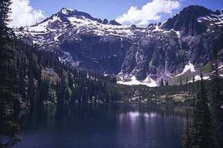
The Selway–Bitterroot Wilderness is a protected wilderness area in the states of Idaho and Montana, in the northwestern United States. At 1.3 million acres (5,300 km²), it is one of the largest designated wilderness areas in the United States.

The Nez Perce National Forest is a 4,000,000-acre (16,000 km2) United States National Forest located in west-central Idaho. The forest is bounded on the east by the state of Montana, on the north by the Clearwater National Forest, on the west by a portion of the Wallowa–Whitman National Forest and on the south by the Payette National Forest.

Clearwater National Forest with headquarters on the Nez Perce Reservation at Kamiah is located in North Central Idaho in the northwestern United States. The forest is bounded on the east by the state of Montana, on the north by the Idaho Panhandle National Forest, and on the south and west by the Nez Perce National Forest and Palouse Prairie.

The Great Fire of 1910 was a wildfire in the Inland Northwest region of the United States that burned three million acres in North Idaho and Western Montana, with extensions into Eastern Washington and Southeast British Columbia, in the summer of 1910. The area burned included large parts of the Bitterroot, Cabinet, Clearwater, Coeur d'Alene, Flathead, Kaniksu, Kootenai, Lewis and Clark, Lolo, and St. Joe national forests.

The Beaverhead–Deerlodge National Forest is the largest of the National Forests in Montana, United States. Covering 3.36 million acres (13,600 km2), the forest is broken into nine separate sections and stretches across eight counties in the southwestern area of the state. President Theodore Roosevelt named the two forests in 1908 and they were merged in 1996. Forest headquarters are located in Dillon, Montana. In Roosevelt's original legislation, the Deerlodge National Forest was called the Big Hole Forest Reserve. He created this reserve because the Anaconda Copper Mining Company, based in Butte, Montana, had begun to clearcut the upper Big Hole River watershed. The subsequent erosion, exacerbated by smoke pollution from the Anaconda smelter, was devastating the region. Ranchers and conservationists alike complained to Roosevelt, who made several trips to the area. (Munday 2001)

Bitterroot National Forest comprises 1.587 million acres (6,423 km2) in west-central Montana and eastern Idaho of the United States. It is located primarily in Ravalli County, Montana, but also has acreage in Idaho County, Idaho (29.24%), and Missoula County, Montana (0.49%).

Lolo National Forest is a national forest located in western Montana, United States with the western boundary being the state of Idaho. The forest spans 2 million acres (8,000 km2) and includes four wilderness areas; the Scapegoat and the Selway-Bitterroot Wilderness are partially within the forest while the Welcome Creek and Rattlesnake Wildernesses are solely in Lolo National Forest. The forest was created in 1906 from 4 different previous forests which were combined for administrative purposes. Lolo National Forest is west of the Continental divide and has a biodiversity influenced by both continental and maritime weather creating a transitional forest that has a high number of different plant and tree species.
Nez Perce Pass is a mountain pass in the Bitterroot Mountains on the border between the U.S. states of Idaho and Montana. The pass is at an elevation of 6,587 feet (2,008 m) above sea level. The Nez Perce Pass Trailhead offers access to the Selway-Bitterroot Wilderness and the Frank Church—River of No Return Wilderness.

The Yellowstone fires of 1988 collectively formed the largest wildfire in the recorded history of Yellowstone National Park in the United States. Starting as many smaller individual fires, the flames quickly spread out of control due to drought conditions and increasing winds, combining into several large conflagrations which burned for several months. The fires almost destroyed two major visitor destinations and, on September 8, 1988, the entire park was closed to all non-emergency personnel for the first time in its history. Only the arrival of cool and moist weather in the late autumn brought the fires to an end. A total of 793,880 acres (3,213 km2), or 36 percent of the park, burned at varying levels of severity.

Elk in the Bitterroot River is a wildlife photograph by John McColgan, a fire behavior analyst who worked for the Alaska Fire Service division of the Bureau of Land Management. It was taken on August 6, 2000, on the East Fork of the Bitterroot River on the Sula Complex, Bitterroot National Forest, Montana, United States, and is also sometimes known by the title, Bitterroot Forest Fire or, more vaguely, Montana Fire. When NASA featured it in its online Astronomy Picture of the Day series, it was called Fire on Earth. The image shows two Rocky Mountain elk seeking protection from a wildfire by standing in the river.

The United States' contiguous western and especially southwestern region has experienced widespread drought since about year 2000. Below normal precipitation leads to drought, and is caused by an above average persistence of high pressure over the affected area. Changes in the track of extratropical cyclones, which can occur during climate cycles such as the El Niño-Southern Oscillation, or ENSO, as well as the North Atlantic Oscillation, Pacific Decadal Oscillation, and Atlantic multidecadal oscillation, modulate which areas are more prone to drought. Increased drought frequency and severity is also expected to be one of the effects of global warming.

The Murphy Complex Fire was a 2007 wildfire that included acreage upon the Bureau of Land Management (BLM) Bruneau and Jarbidge Field Offices of Idaho, BLM Elko Field Office of Nevada, and Forest Service Mountain City and Jarbidge Districts of Nevada. It burned an estimated 652,016 acres (263,862 ha) of land. By acreage, it was the third largest wildfire in the United States between 1997 and 2009. The fire affected Owyhee and Twin Falls counties in Idaho, and Elko County, Nevada. Nearly three times as much acreage burned in the two Idaho counties as burned in Nevada. Aerial crews were primarily responsible for fighting the fire in Castleford, Idaho. About 560 wildfire firefighters were involved including a Type 1 team that specializes in fighting large wildfires. This was the third large fire in as many years on land managed by the Jarbidge Field Office in Idaho's Twin Falls District. Because of this, the BLM held a workshop on large wildfires in the district on May 12–14, 2009.


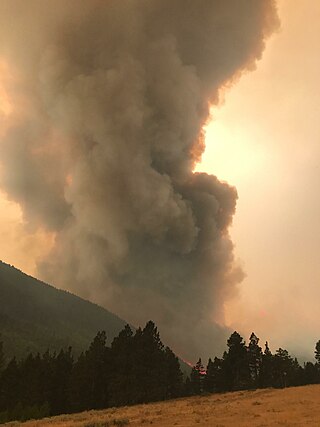
The Lolo Peak Fire was a wildfire in Lolo National Forest and Bitterroot National Forest, Montana in the United States, that began by lightning strikes on the western flank of Lolo Peak, 10 miles southwest of Lolo, Montana on July 15, 2017. The fire burned a total of 53,902 acres (218 km2). One firefighter, Brent Witham, was killed working the fire, and another firefighter was injured. Two homes were destroyed, over 3,000 people were evacuated and 1,150 residences were threatened. The fire threatened homes along Highway 12 and Highway 93, impacting recreational activities in the area and the communities of Lolo and Florence.
The 2017 Montana wildfires were a series of wildfires that burned over the course of 2017.

Wildfires can happen in many places in the United States, especially during droughts, but are most common in the Western United States and Florida. They may be triggered naturally, most commonly by lightning, or by human activity like unextinguished smoking materials, faulty electrical equipment, overheating automobiles, or arson.
The 2021 wildfire season involves wildfires on multiple continents. Even at halfway through the calendar year, wildfire seasons were larger than in previous history, with increased extreme weather caused by climate change strengthening the intensity and scale of fires.

The following is a list of weather events that occurred in 2021. The year began with La Niña conditions. There were several natural disasters around the world from various types of weather, including blizzards, cold waves, droughts, heat waves, tornadoes, and tropical cyclones. In December, powerful Typhoon Rai moved through the southern Philippines, killing 410 people and becoming the deadliest single weather event of the year. The costliest event of the year, and the costliest natural disaster on record in the United States, was from a North American cold wave in February 2021, which caused $196.4 billion (USD) in damage; the freezing temperatures and widespread power outages in Texas killed hundreds of people. Another significant natural disaster was Hurricane Ida, which struck southeastern Louisiana and later flooded the Northeastern United States, resulting in $70 billion (USD) in damage. December saw two record-breaking tornado outbreaks, only four days apart from each other. In Europe, the European Severe Storms Laboratory documented 1,482 weather-related injuries and 568 weather-related fatalities. The National Oceanic and Atmospheric Administration documented 796 weather-related fatalities and at least 1,327 weather-related injuries in the United States and the territories of the United States.

On December 15, 2021, the Midwestern U.S. state of Kansas was met with strong and damaging winds caused by the December 2021 Midwest derecho and tornado outbreak, which produced dust storms and multiple wildfires. An estimated 163,000 acres (66,000 ha) burned on the first day wildfires spawned due to dry fuel and strong wind gusts reaching up to 100 mph (160 km/h). The western and central portions of Kansas were mostly affected by the fires. Before December 15, forecasters had predicted that dry air, gusty winds, and warm temperatures could be present throughout the following days, creating conditions favorable for wildfires to spread quickly through the area. The largest wildfire, the Four County Fire, burned numerous buildings and killed hundreds of cattle along the way with a scorched area of 121,622 acres (49,219 ha).
References
- ↑ Billion Dollar Weather Disasters 1980 - 2008 [ permanent dead link ] National Climatic Data Center . Accessed 2009-02-01.
- ↑ White, Katherine (15 December 2003). The 2000-2002 Forest Fires in the Western United States By Katherine White. The Rosen Publishing Group. ISBN 9780823944880.
- 1 2 Ward, Tony J.; Smith, Garon C. "Air Sampling Study of the 2000 Montana Wildfire Season". University of Montana.
- ↑ "Northern Idaho and Western Montana Summer 2000 Wildfires" (PDF). U.S. Department of Commerce - NOAA. February 2001.
- Lorch, Donatella, and Mark Matthews. "Flaming Fury." -Newsweek- 21 August 2000: 58-59.
- Engelbett, Phillis. "Wildfire." -Dangerous Planet The Science of Natural Disasters.- Vol.3. Ed. Phillis Engelbert. Detroit: The Gale Group, 2001