
A grassland is an area where the vegetation is dominated by grasses (Poaceae). However, sedge (Cyperaceae) and rush (Juncaceae) can also be found along with variable proportions of legumes, like clover, and other herbs. Grasslands occur naturally on all continents except Antarctica and are found in most ecoregions of the Earth. Furthermore, grasslands are one of the largest biomes on Earth and dominate the landscape worldwide. There are different types of grasslands: natural grasslands, semi-natural grasslands, and agricultural grasslands. They cover 31–69% of the Earth's land area.

A savanna or savannah is a mixed woodland-grassland biome and ecosystem characterised by the trees being sufficiently widely spaced so that the canopy does not close. The open canopy allows sufficient light to reach the ground to support an unbroken herbaceous layer consisting primarily of grasses. Four savanna forms exist; savanna woodland where trees and shrubs form a light canopy, tree savanna with scattered trees and shrubs, shrub savanna with distributed shrubs, and grass savanna where trees and shrubs are mostly nonexistent.
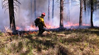
A controlled or prescribed (Rx) burn is the practice of intentionally setting a fire to change the assemblage of vegetation and decaying material in a landscape. The purpose could be for forest management, ecological restoration, land clearing or wildfire fuel management. A controlled burn may also refer to the intentional burning of slash and fuels through burn piles. Controlled burns may also be referred to as hazard reduction burning, backfire, swailing or a burn-off. In industrialized countries, controlled burning regulations and permits are usually overseen by fire control authorities.

The Llanos is a vast tropical grassland plain situated to the east of the Andes in Colombia and Venezuela, in northwestern South America. It is an ecoregion of the tropical and subtropical grasslands, savannas, and shrublands biome.

Fire ecology is a scientific discipline concerned with the effects of fire on natural ecosystems. Many ecosystems, particularly prairie, savanna, chaparral and coniferous forests, have evolved with fire as an essential contributor to habitat vitality and renewal. Many plant species in fire-affected environments use fire to germinate, establish, or to reproduce. Wildfire suppression not only endangers these species, but also the animals that depend upon them.
The Texas-Oklahoma wildfires of 2005–06 were a series of wildfires, primarily in the states of Texas and Oklahoma, that began November 27, 2005 and continued into April 2006. Surrounding states were also affected to a lesser extent.

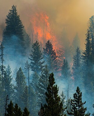
The Yellowstone fires of 1988 collectively formed the largest wildfire in the recorded history of Yellowstone National Park in the United States. Starting as many smaller individual fires, the flames quickly spread out of control due to drought conditions and increasing winds, combining into several large conflagrations which burned for several months. The fires almost destroyed two major visitor destinations and, on September 8, 1988, the entire park was closed to all non-emergency personnel for the first time in its history. Only the arrival of cool and moist weather in the late autumn brought the fires to an end. A total of 793,880 acres (3,213 km2), or 36 percent of the park, burned at varying levels of severity.

Severe weather is any dangerous meteorological phenomenon with the potential to cause damage, serious social disruption, or loss of human life. These vary depending on the latitude, altitude, topography, and atmospheric conditions. High winds, hail, excessive precipitation, and wildfires are forms and effects, as are thunderstorms, downbursts, tornadoes, waterspouts, tropical cyclones, and extratropical cyclones. Regional and seasonal phenomena include blizzards (snowstorms), ice storms, and duststorms.

The climate of Zambia in Central and Southern Africa is definitely tropical modified by altitude (elevation). In the Köppen climate classification, most of the country is classified as humid subtropical or tropical wet and dry, with small patches of semi-arid steppe climate in the south-west.
The biomes and ecoregions in the ecology of Zambia are described, listed and mapped here, following the World Wildlife Fund's classification scheme for terrestrial ecoregions, and the WWF freshwater ecoregion classification for rivers, lakes and wetlands. Zambia is in the Zambezian region of the Afrotropical biogeographic realm. Three terrestrial biomes are well represented in the country . The distribution of the biomes and ecoregions is governed mainly by the physical environment, especially climate.
Wildfires consume live and dead fuels, destabilize physical and ecological landscapes, and impact human social and economic systems. Post-fire seeding was initially used to stabilize soils. More recently it is being used to recover post wildfire plant species, manage invasive non-native plant populations and establish valued vegetation compositions.

The 2004 Alaska fire season was the worst wildfire season on record in the U.S. state of Alaska in terms of area burned. Though the 1989 fire season recorded more fires, nearly 1,000, the 2004 season burned more than 6,600,000 acres in just 701 fires. The largest of these fires was the Taylor Complex Fire. This fire consumed over 1,700,000 acres and was the deemed to be the largest fire in the United States from at least 1997 to 2019. Out of all 701 fires, 426 fires were started by humans and 215 by lightning.

The Las Conchas Fire was a large wildfire in the state of New Mexico, in the United States, in 2011. The fire started in Santa Fe National Forest and burned more than 150,000 acres, threatening Los Alamos National Laboratory and the town of Los Alamos. After five days of burning, it became the largest wildfire in New Mexico state history at the time. It was surpassed in 2012 by the much larger Whitewater-Baldy Complex Fire and in 2022 by the Calf Canyon/Hermits Peak Fire and the Black Fire making the Las Conchas Fire the fourth-largest fire in New Mexico's recorded history.

Mediterranean forests, woodlands and scrub is a biome defined by the World Wide Fund for Nature. The biome is generally characterized by dry summers and rainy winters, although in some areas rainfall may be uniform. Summers are typically hot in low-lying inland locations but can be cool near colder seas. Winters are typically mild to cool in low-lying locations but can be cold in inland and higher locations. All these ecoregions are highly distinctive, collectively harboring 10% of the Earth's plant species.
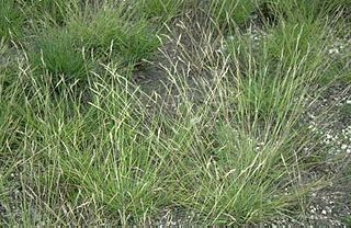
Danthonia spicata is a species of grass known by the common name poverty oatgrass, or simply poverty grass. It is native to North America, where it is widespread and common in many areas. The species is distributed across much of Canada and the United States, and its distribution extends into northern Mexico.

Wildfires are outdoor fires that occur in the wilderness or other vast spaces. Other common names associated with wildfires are brushfire and forest fire. Since wildfires can occur anywhere on the planet, except for Antarctica, they pose a threat to civilizations and wildlife alike. In terms of emergency management, wildfires can be particularly devastating. Given their ability to destroy large areas of entire ecosystems, there must be a contingency plan in effect to be as prepared as possible in case of a wildfire and to be adequately prepared to handle the aftermath of one as well.
The ecology of the Great Plains is diverse, largely owing to their great size. Differences in rainfall, elevation, and latitude create a variety of habitats including short grass, mixed grass, and tall-grass prairies, and riparian ecosystems.
The Beaver Creek Fire was a forest fire that began on August 7, 2013 after a lightning strike in an area twelve miles northeast of Fairfield, Idaho and northwest of Hailey, Idaho in Sawtooth National Forest. The fire burned through pine trees, sagebrush, timber in the understory, grass, and various riparian areas. The fire coated the resort areas of Hailey, Ketchum, and Sun Valley, in a layer of thick soot and ash. By the time the fire was fully contained on August 31, 114,900 acres of the Ketchum Ranger District of Sawtooth National Forest has been burned. Of the 114,900 acres burned, 57,000 acres were moderately damaged and 9,500 acres were severely damaged.

The 2017 Oregon wildfires were a series of wildfires that burned over the course of 2017.

The Frye Fire was a wildfire that burned 48,443 acres (19,604 ha) in Graham County, Arizona, United States, from June 7 to September 1, 2017. The fire was ignited by a lightning strike on Mount Graham, within the Coronado National Forest, and spread rapidly until it was mostly contained on July 12. The Frye Fire destroyed three buildings, briefly threatened the Mount Graham International Observatory, cost $26 million to contain and suppress, and involved more than 800 firefighters. There were no fatalities, but 63 firefighters were quarantined as a result of a strep throat outbreak.
