Related Research Articles

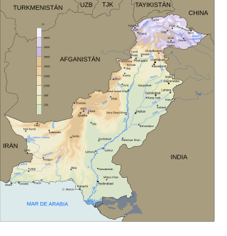
The Geography of Pakistan encompasses a wide variety of landscapes varying from plains to deserts, forests, and plateaus ranging from the coastal areas of the Indian Ocean in the south to the mountains of the Karakoram, Hindukush, Himalayas ranges in the north. Pakistan geologically overlaps both with the Indian and the Eurasian tectonic plates where its Sindh and Punjab provinces lie on the north-western corner of the Indian plate while Balochistan, most of Khyber Pakhtunkhwa, and Gilgit-Baltistan lie within the Eurasian plate which mainly comprises the Iranian Plateau and the Tibetan Plateau in the north.
Karachi has a tropical semi arid climate, albeit a moderate version of this climate, influenced by monsoons. Karachi has a tropical climate, despite being located slightly above the Tropic of Cancer. It is situated in the monsoon region of Pakistan. It is located on the coast bordering the Arabian Sea, and as a result, has a relatively mild climate. However, in more recent years, rainfall has become more abundant, with annual rainfall projected to reach over 500 mm by 2100. For this reason, the city may be classed as almost semi-arid (BSh), since it has a mild climate with a short but defined wet season, along with a lengthy dry season.

The four provinces, a capital territory, and two administrative territories of Pakistan are subdivided into 38 administrative "divisions", which are further subdivided into districts, tehsils, and finally union councils. These divisions were abolished in 2000, but restored in 2008.

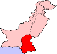
Rajanpur is a district of Dera Ghazi Khan Division in the Pakistani province of Punjab, with its administrative headquarters the city of Rajanpur. District of Rajanpur was formerly part of Dera Ghazi Khan District and was created on 1 July 1982. According to the 2023 Pakistani census, the district had a population of 2,323,980.

Pakistan's climate varies from a continental type of climate in the north (Gilgit-Baltistan,Kashmir,KPK), a mountainous dry climate in the west (Baluchistan), a wet climate in the East (Punjab) an arid climate in the Thar Desert, to a tropical climate in the southeast (Sindh), characterized by extreme variations in temperature, both seasonally and daily, because it is located on a great landmass barely north of the Tropic of Cancer.

Very Severe Cyclonic Storm Phet was a powerful tropical cyclone that made landfall on Oman, Western India, and Pakistan. The third named cyclone of the 2010 cyclone season, Phet developed in the Arabian Sea on May 31 to the west of India. With conducive environmental conditions, the storm intensified to reach peak sustained winds of 155 km/h (95 mph) on June 2, based on analysis by the India Meteorological Department (IMD). On the next day, Phet dropped heavy rainfall while moving across eastern Oman, with a peak of 603 mm (23.7 in) in Qurayyat. The rains flooded arid areas and collected into wadis – normally dry river beds. Thousands of homes were wrecked across Oman. There were 24 fatalities in the country, and damage was estimated at US$780 million.

The floods in Pakistan began in late July 2010, resulting from heavy monsoon rains in the Khyber Pakhtunkhwa, Sindh, Punjab and, Balochistan regions of Pakistan, which affected the Indus River basin. Approximately one-fifth of Pakistan's total land area was affected by floods, with the Khyber Pakhtunkhwa province facing the brunt of the damage and casualties. Nationwide, there were 1,985
Quetta, Pakistan features a continental semi-arid climate with a large variation between summer and winter temperatures. The highest temperature recorded in Quetta was 42 °C (108 °F) on 10 July 1998. The lowest temperature in Quetta is −18.3 °C (−0.9 °F) which was recorded on 8 January 1970.

South Punjab, also proposed as Bahawalpur-South Punjab or Bahawalpur Janoobi Punjab, are the names for the proposals to create a new province in Pakistan, out of the southern regions of Punjab. The region comprises the Bahawalpur, Multan and Dera Ghazi Khan divisions. The proposed province would form about 52 percent of the total area and almost 40 percent of the population of the current Punjab province. It has also been proposed to create instead two provinces in South Punjab.
The 2011 Sindh floods was the highest-ever recorded rainfall between 11 August 2011, and 14 September 2011 in Sindh Province, Pakistan.

Saraiki cuisine refers to the native cuisine of the Saraiki people in central Pakistan. It is one of the key part of the Pakistani and South Asian cuisines. The style of cooking is present in the Saraiki-speaking region of southern Punjab, as well as parts of southern Khyber Pakhtunkhwa, northern Sindh and northeastern Balochistan. Saraiki food comprises many unique local dishes, and also shares influences with neighbouring regional cuisines. The metropolitan city of Multan is a hub of Saraiki cooking.
From February to April 2019, widespread flash flooding affected large parts of Pakistan, most severely in Balochistan, KPK, Punjab, and other provinces. Pakistan has been hit by three major waves of rain and flooding over the course of more than one month. The first wave of rain began on 20 February, leading to flooding in to Khyber and Balochistan, therefore many villages and several cities have been evacuated, and more than 1,500 families has been rescued alone in Balochistan and many in other states. The 20 February rain and thunderstorms caused flash floods in the Lasbela area. The main areas affected were Turbat, Tump, Nasirabad and Dasht where 300 people were displaced due to the flood. These people were then moved to camps established by the Provincial Disaster Management Authority (PDMA). Casualties have came mostly due to roof collapsing amid heavy rains and flash flooding. Khyber Pakhtunwkha has witnessed the most deaths till now, 40, alongside Balochsitan has faced 26 casualties with more than 9 in Punjab and other places. Due to rain, flood and storm casualties are increasing.
In mid-March 2019, monsoonal downpours caused widespread flooding and landslides across South Asia.
In 2016 Pakistan experienced higher rainfall than normal (10-20%), especially in the pre-monsoon season. Heavy monsoon rains are common in the region. This led to multiple periods of flooding, landslides, and damage particularly in Northern Pakistan. The Swat River overflowed and multiple landslides occurred around Pakistan including in Khyber Pakhtunkhwa, Gilgit-Baltistan, Azad Jammu, and Kashmir.
From January to October 2022, excessive rainfall and widespread monsoon flooding occurred in the South Asian countries of Afghanistan, Bangladesh, India, Nepal, Pakistan, and Sri Lanka. It has become the region's deadliest floods since 2020, with over 4,700 people dead.
The events listed below are both anticipated and scheduled for the year 2023 in Pakistan.
Since 29 February 2024, flooding affected various regions across the country, including Sindh, Balochistan, Khyber Pakhtunkhwa, and Gilgit-Baltistan. At least 40 people were killed and 62 injured in the floods. Floods caused by heavy rains caused widespread destruction, disrupting normal life and damaging infrastructure. The government declared a state of emergency in several areas, and relief operations were launched by various agencies, including the Pakistan Navy, Pakistan Army, and the Frontier Corps.

Cyclonic Storm Asna was a tropical cyclone that affected Gujarat, Rajasthan and Madhya Pradesh states of India and southern Pakistan from 25 August to 2 September 2024. It formed as deep depression over land, intensified in the cyclone and moved into Arabian Sea. The heavy rains from deep depression caused widespread flooding across Gujarat and Sindh, leading to the deaths of 49 people in India and 24 in Pakistan, while also inflicting significant damage to infrastructure, private property, and agricultural lands.
References
- ↑ "Floods killed 455, affected five million: NDMA". 17 October 2012.
- ↑ "Rain batters Punjab; 18 lives lost". Dawn.Com. 10 September 2012. Retrieved 12 September 2012.
- ↑ "Rain system rapidly weakening". Dawn.Com. 11 September 2012. Retrieved 12 September 2012.