
The Maluku Islands or the Moluccas are an archipelago in the eastern part of Indonesia. Tectonically they are located on the Halmahera Plate within the Molucca Sea Collision Zone. Geographically they are located east of Sulawesi, west of New Guinea, and north and east of Timor. Lying within Wallacea, the Moluccas have been considered as a geographical and cultural intersection of Asia and Oceania.

North Maluku is a province of Indonesia. It covers the northern part of the Maluku Islands, bordering the Pacific Ocean to the north, the Halmahera Sea to the east, the Molucca Sea to the west, and the Seram Sea to the south. It shares a maritime borders with North Sulawesi,, Southeast Sulawesi and Central Sulawesi to the west, Maluku to the south, Southwest Papua to the west, and Palau and the Philippines to the north. The provincial capital is Sofifi on the largest island of Halmahera, while the largest city is the island city of Ternate. The population of North Maluku was 1,038,087 in the 2010 census, making it one of the least-populous provinces in Indonesia, but by the 2020 Census the population had risen to 1,282,937, and the official estimate as at mid 2022 was 1,319,338.

West Nusa Tenggara is a province of Indonesia. It comprises the western portion of the Lesser Sunda Islands, with the exception of Bali which is its own province. Mataram, on Lombok, is the capital and largest city of the province. It shares maritime borders with Bali to the west and East Nusa Tenggara to the east. The 2010 census recorded the population at 4,500,212; the total rose to 4,830,118 at the 2015 Intermediate Census and 5,320,092 at the 2020 census; the official estimate as at mid 2022 was 5,473,671. The province's area is 20,153.15 km2. The two largest islands by far in the province are Lombok in the west and the larger Sumbawa island in the east.

Morotai Island Regency is a regency of North Maluku province, Indonesia, located on Morotai Island. It covers an area of 2,336.6 km2 including the smaller Rao Island to the west of Morotai. The population was 52,860 at the 2010 census and 74,436 at the 2020 census; the official estimate as at mid 2022 was 78,270.
Halmahera, formerly known as Jilolo, Gilolo, or Jailolo, is the largest island in the Maluku Islands. It is part of the North Maluku province of Indonesia, and Sofifi, the capital of the province, is located on the west coast of the island.

Maluku is a province of Indonesia. It comprises the central and southern regions of the Maluku Islands. The largest city and capital of Maluku province is Ambon on the small Ambon Island. It is directly adjacent to North Maluku, Southwest Papua, and West Papua in the north, Central Sulawesi, and Southeast Sulawesi in the west, Banda Sea, Australia, East Timor and East Nusa Tenggara in the south and Arafura Sea, Central Papua and South Papua in the east. The land area is 46,150.92 km2, and the total population of this province at the 2010 census was 1,533,506 people, rising to 1,848,923 at the 2020 census. The official estimate as at mid 2022 was 1,881,727. Maluku is located in Eastern Indonesia.

The following table indicates declared Indonesian government national holidays. Cultural variants also provide opportunity for holidays tied to local events. Beside official holidays, there are the so-called "libur bersama" or "cuti bersama", or joint leave(s) declared nationwide by the government. In total there are 16 public holidays every year.

Ternate, also known as the City of Ternate, is a city in the Indonesian province of North Maluku and an island in the Maluku Islands. It was the de facto provincial capital of North Maluku before Sofifi on the nearby coast of Halmahera became the capital in 2010. It is off the west coast of Halmahera, and is composed of eight islands: Ternate, the biggest and main island of the city, and Moti, Hiri, Tifure, Mayau, Makka, Mano, and Gurida. In total, the city has a land area of 162.17 square kilometres and had a total population of 185,705 according to the 2010 census, and 205,001 according to the 2020 census, with a density of 1,264 people per square kilometre; the official estimate as at mid 2022 was 206,745. It is the biggest and most densely populated city in the province, is the economic, cultural, and education center of North Maluku, and acts as a hub to neighbouring regions. It was the capital of the Sultanate of Ternate in the 15th and 16th centuries, and fought against the Sultanate of Tidore over control of the spice trade in the Moluccas before becoming a main interest to competing European powers.

The Indonesian Navy is the naval branch of the Indonesian National Armed Forces. It was founded on 10 September 1945 and has a role to patrol Indonesia's lengthy coastline, to enforce and patrol the territorial waters and Exclusive Economic Zone (EEZ) of Indonesia, to protect Indonesia's maritime strategic interests, to protect the islands surrounding Indonesia, and to defend against seaborne threats.

Sail Indonesia is a series of sailing and other events for yachts conducted each year in Indonesia. The events are organised by Yayasan Cinta Bahari Indonesia (YCBI) and supported by the high-profile tourist destinations to international yachtsmen and women with a view to expanding the tourism potential and raising awareness of the region as well as introducing visitors to natural and cultural features of the Indonesian archipelago that they might otherwise not visit.

USS Iredell County (LST-839) was an LST-542-class tank landing ship built for the United States Navy during World War II. Named after Iredell County, North Carolina, she was the only U.S. Naval vessel to bear the name.
Leo Wattimena Airport, formerly known as Pitu Airport (IATA: OTI, ICAO: WAEW (formerly WAMR)) is a private airport located on the southern coast of Morotai Island, North Maluku, Indonesia.

North Halmahera Regency is a regency of North Maluku Province, Indonesia. It was declared a Regency on 31 May 2003, formed from part of the former North Maluku Regency. The capital town of the regency lies at the port of Tobelo. The Regency, which has been considerably reduced by the separation of Tidore and of Morotai Island, now covers an area of 3,891.62 square kilometres (1,502.56 sq mi) and had a population of 161,847 people at the 2010 Census, 179,783 at the 2015 Intermediate Census. and 197,640 at the 2020 Census. The official estimate as at mid 2022 was 202,755. The principal settlements are Tobelo, Kao and Galela. The area is noted for its white beaches and coral reefs.

Raja Ampat Regency is a regency of Southwest Papua Province of Indonesia. The regency, which was formed by separating the archipelago from Sorong Regency, based on the Law 26 of 2002, was inaugurated on 12 April 2003. It consists of a number of groups of islands situated off the north-west end of West Papua; the four main islands from south to north are Misool, Salawati, Batanta, and Waigeo. At present, the regency covers a land area of 7,559.60 km2, with a total area stated as 67,379.61 km2. It had a population of 42,508 at the 2010 Census and 64,141 at the 2020 Census; the official estimate as at mid 2022 was 66,839. The principal town lies at Waisai on Waigeo Island.
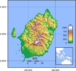
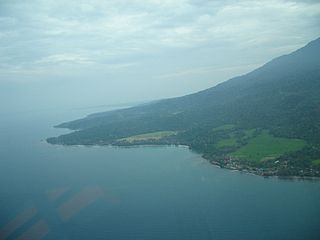
Morotai Island is an island in the Halmahera group of eastern Indonesia's Maluku Islands (Moluccas). It is one of Indonesia's northernmost islands.

Bandanaira Airport is the airport on Banda Neira in the Banda Islands of Maluku, Indonesia and one of the smallest airports in the country. The Banda Islands are a popular tourist destination for divers and snorkelers.
Coordinating Ministry for Economic Affairs is the Indonesian government ministry in charge of planning and policy co-ordination, as well as synchronisation of policies in the fields of economics. The ministry is led by a Coordinating Minister for Economics Affairs, who is Airlangga Hartarto since 23 October 2019.

Coordinating Ministry for Maritime and Investment Affairs is the Indonesian government ministry in charge of planning, coordinating as well as synchronizing policies in maritime affairs and investment. The coordinating minister for Maritime and Investment Affairs is Luhut Binsar Pandjaitan.

SS India Victory was a Victory ship built and operated as a cargo carrier and troopship in World War II. After the war the ship was used a private cargo ship. She sank on 12 July 1972, ran aground on a Pratas Reef in the South China in Typhoon Susan.

The Investment Coordinating Board is Non-Ministerial Government Body in Indonesia for formulation of government policies in the field of investment, both domestically and abroad.
