Hurricane Mitch was the second-deadliest Atlantic hurricane on record, only after the Great Hurricane of 1780 which killed at least 22,000 people. Hurricane Mitch caused 11,374 fatalities in Central America in 1998, including approximately 7,000 in Honduras and 3,800 in Nicaragua due to cataclysmic flooding from the slow motion of the storm. It was the deadliest hurricane in Central American history, surpassing Hurricane Fifi–Orlene, which killed slightly fewer people there in 1974.

Hurricane Opal was a large and powerful Category 4 hurricane that caused severe and extensive damage along the northern Gulf Coast of the United States in October 1995. The fifteenth named storm, ninth hurricane and strongest tropical cyclone of the unusually active 1995 Atlantic hurricane season, Opal developed from the interaction of a tropical wave and a low-pressure area near the Yucatán Peninsula on September 27 as Tropical Depression Seventeen. The depression crossed the Yucatán Peninsula and intensified into a tropical storm on September 30. Opal intensified into a hurricane on October 2 after entering the Gulf of Mexico. The cyclone turned northeastward and strengthened significantly. By October 4, Opal was an intense 150 mph (240 km/h), Category 4 hurricane. With a minimum pressure of 916 mbar (hPa), Hurricane Opal was the most intense category 4 Atlantic hurricane on record. However, the cyclone abruptly weakened to a low-end Category 3 hurricane prior to making landfall on the Florida Panhandle near Pensacola later that day. The storm quickly unraveled as it moved inland and became extratropical on October 5. The remnants of Opal moved northward and dissipated over Ontario the following day.
Hurricane Inez was a powerful major hurricane that affected the Caribbean, Bahamas, Florida, and Mexico in 1966. It was the first storm on record to affect all of those areas. It originated from a tropical wave over Africa, and became a tropical depression by September 21. It moved slowly westward, initially failing to intensify much; it was upgraded to Tropical Storm Inez on September 24. The storm strengthened into a hurricane and was quickly intensifying when it struck the French overseas region of Guadeloupe on September 27. Inez severely damaged the island's banana and sugar crops, and thousands of homes were damaged, leaving 10,000 people homeless. Damage on Guadeloupe was estimated at $50 million, and there were 40 deaths. After entering the Caribbean, Inez briefly weakened before restrengthening, attaining peak sustained winds of 165 mph (270 km/h) on September 28, eventually making landfall at that intensity in the Dominican Republic. That day a hurricane hunters flight reported a gust of 197 mph (317 km/h), which was the highest recorded at the time.
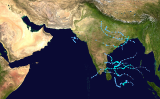
The 2005 North Indian Ocean cyclone season caused much devastation and many deaths in Southern India despite the storms’ weakness. The basin covers the Indian Ocean north of the equator as well as inland areas, sub-divided by the Arabian Sea and the Bay of Bengal. Although the season began early with two systems in January, the bulk of activity was confined from September to December. The official India Meteorological Department tracked 12 depressions in the basin, and the unofficial Joint Typhoon Warning Center (JTWC) monitored two additional storms. Three systems intensified into a cyclonic storm, which have sustained winds of at least 63 km/h (39 mph), at which point the IMD named them.

Typhoon Zeb, known in the Philippines as Typhoon Iliang, was a powerful typhoon that struck the island of Luzon in October 1998. It is tied with Cyclone Ron and Cyclone Susan in terms of minimum pressure, for the most intense tropical cyclone worldwide for 1998. The tenth tropical storm of the season, Zeb formed on October 10 from the monsoon trough near the Caroline Islands. It moved westward initially and quickly intensified. Zeb's inflow briefly spawned another tropical storm, which it ultimately absorbed. Developing an eye, Zeb rapidly intensified into a super typhoon, officially reaching maximum sustained winds of 205 km/h (125 mph); one warning agency estimated winds as high as 285 km/h (180 mph). After reaching peak intensity, the typhoon struck northern Luzon and quickly weakened over land. Turning to the north, Zeb brushed the east coast of Taiwan at a reduced intensity, and after accelerating to the northeast it moved through Japan. It became extratropical on October 18 and moved eastward over open waters.
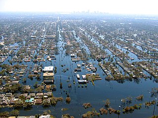
Floods in the United States (2000–present) is a list of flood events which were of significant impact to the country during the 21st century, since 2000. Floods are generally caused by excessive rainfall, excessive snowmelt, storm surge from hurricanes, and dam failure.

In October 1999, severe flooding affected portions of eastern Mexico and Central America. Rainfall in September preceded the primary event in Mexico, which moistened soils. On October 4, Tropical Depression Eleven developed in the Gulf of Mexico, which drew humidity from the gulf and the Pacific Ocean to produce torrential rainfall in mountainous regions of eastern Mexico, reaching 43.23 in (1,098 mm) in Jalacingo, Veracruz. This was the third-highest tropical cyclone-related rainfall total in Mexico from 1980–2006, and the event caused the highest rainfall related to tropical cyclones in Veracruz, Hidalgo, and Puebla. In some locations, the daily rainfall represented over 10% of the annual precipitation total. The heaviest rainfall occurred in mountainous regions that were the mouths of several rivers. A broad trough absorbed the depression on October 6, and rainfall continued for the next few days. Additional rainfall occurred in Tabasco state on October 18. The floods were estimated as a 1 in 67 year event in one location, although such floods are expected to affect eastern Mexico twice per century, the last time being 1944.
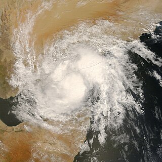
Deep Depression ARB 02 was a weak tropical cyclone that caused extensive damage and loss of life in Yemen in October 2008. The sixth tropical cyclone and third deep depression of the 2008 North Indian Ocean cyclone season, ARB 02 formed on October 19 off the west coast of India from the same broader system that spawned a tropical storm in the southern Indian Ocean at the same time. Moving generally westward, the depression failed to intensify much, reaching maximum sustained winds of only 55 km/h (35 mph). It was no longer classifiable as a tropical depression by October 23, and later that day, its remnants made landfall near Ash Shihr in eastern Yemen.

Severe Cyclonic Storm Aila was the second named tropical cyclone of the 2009 North Indian Ocean cyclone season. Warned by both the Regional Specialized Meteorological Center (RMSC) and Joint Typhoon Warning Center (JTWC), Aila formed over a disturbance over the Bay of Bengal on May 23, 2009 and started to intensify and organize reaching sustained wind speeds of 110 kmh (70 mph). It was the worst natural disaster to affect Bangladesh since Cyclone Sidr in November 2007. A relatively strong tropical cyclone, it caused extensive damage in India and Bangladesh.

The 2010 Ladakh floods occurred on 6 August 2010 across a large part of Ladakh, then part of the state of Jammu and Kashmir. 71 towns and villages were damaged, including the main town in the area, Leh. At least 255 people are reported to have died, six of whom were foreign tourists, after a cloudburst and heavy overnight rains triggered flash floods, mudflows, and debris flows. 200 people were reported missing in the initial aftermath of the storm, and thousands more were rendered homeless after the flooding caused extensive damage to property and infrastructure. Overall, 9000 people were directly affected by the event.

In early 2000, severe flooding occurred in the African nation of Madagascar after Cyclone Leon–Eline and Severe Tropical Storm Gloria struck the nation within a two-week period. The first storm, Eline, formed on February 1, and took an extended track across the Indian Ocean, eventually making landfall near Mahanoro on February 17. On March 1, Gloria struck northeastern Madagascar, and like Eline, moved southwestward across the country.

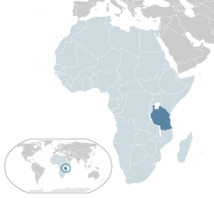
At least 30 tropical cyclones have affected the Southern African mainland. Three southeastern African countries border the Indian Ocean – Tanzania, Mozambique, and South Africa. Other inland countries also experience the effects of tropical cyclones, including Botswana, Eswatini, Lesotho, Malawi, Namibia, Zambia, and Zimbabwe.
Cyclone Savannah was a strong tropical cyclone that brought significant impacts to Java and Bali and minor impacts to Christmas Island and the Cocos (Keeling) Islands during March 2019. It was the sixteenth tropical low, sixth tropical cyclone and third severe tropical cyclone of the 2018–19 Australian region cyclone season. Savannah developed from a tropical low that formed well to the east of Christmas Island on 8 March. The system was slow to develop initially, but reached tropical cyclone intensity on 13 March after adopting a southwesterly track. Savannah underwent rapid intensification and reached peak intensity on 17 March as a Category 4 severe tropical cyclone on the Australian scale. Ten-minute sustained winds were estimated as 175 kilometres per hour (109 mph), with a central barometric pressure of 951 hPa (28.08 inHg). One-minute sustained winds reached 185 kilometres per hour (115 mph) at this time, equivalent to a Category 3 major hurricane on the Saffir–Simpson hurricane wind scale. Weakening commenced soon afterwards, and responsibility for the system passed from the Australian Bureau of Meteorology to Météo-France. As it moved into the new region, Savannah became the eighth of a record-breaking ten intense tropical cyclones in the 2018–19 South-West Indian Ocean cyclone season. Savannah was downgraded to a tropical depression on 20 March, and its remnants dissipated in the central Indian Ocean on 24 March.
The 2020 East Africa floods were a natural disaster in Rwanda, Kenya, Somalia, Burundi, Ethiopia, Uganda, Democratic Republic of Congo, Djibouti and Tanzania, affecting at least 700,000 people. They began when excessive rains began falling in March, leading to massive flooding and landslides. They caused more than 430 deaths, notably in Kenya and Rwanda. In the fall another round of floods hit the African Sahel.

Tropical cyclones regularly affect the coastlines of most of Earth's major bodies of water along the Atlantic, Pacific, and Indian oceans. Also known as hurricanes, typhoons, or other names, tropical cyclones have caused significant destruction and loss of human life, resulting in about 2 million deaths since the 19th century. Powerful cyclones that make landfall – moving from the ocean to over land – are some of the most impactful, although that is not always the case. An average of 86 tropical cyclones of tropical storm intensity form annually worldwide, with 47 reaching hurricane/typhoon strength, and 20 becoming intense tropical cyclones, super typhoons, or major hurricanes.

The effects of the 2020 North Indian Ocean cyclone season in India was considered one of the worst in decades, largely due to Super Cyclonic Storm Amphan. Throughout most of the year, a series of cyclones impacted the country, with the worst damage occurring in May, from Cyclone Amphan. The season started with Super Cyclonic Storm Amphan, which affected East India with very severe damages. 98 total people died from the storm. Approximately 1,167 km (725 mi) of power lines of varying voltages, 126,540 transformers, and 448 electrical substations were affected, leaving 3.4 million without power. Damage to the power grid reached ₹3.2 billion. Four people died in Odisha, two from collapsed objects, one due to drowning, and one from head trauma. Across the ten affected districts in Odisha, 4.4 million people were impacted in some way by the cyclone. At least 500 homes were destroyed and a further 15,000 were damaged. Nearly 4,000 livestock, primarily poultry, died. The cyclone was strongest at its northeast section. The next storm was a depression that did not affect India. Then Severe Cyclonic Storm Nisarga hit Maharashtra, with high damages. Nisarga caused 6 deaths and 16 injuries in the state. Over 5,033 ha of land were damaged.
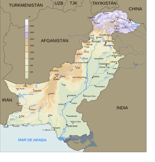
In 2016 Pakistan experienced higher rainfall than normal (10-20%), especially in the pre-monsoon season. Heavy monsoon rains are common in the region. This led to multiple periods of flooding, landslides, and damage particularly in Northern Pakistan. The Swat River overflowed and multiple landslides occurred around Pakistan including in Khyber Pakhtunkhwa, Gilgit-Baltistan, Azad Jammu, and Kashmir.

Throughout 2022, floods affected most of Africa, killing over 2,100 people. The worst affected country was Nigeria, with over 610 deaths.