
The Philippines is an archipelago that comprises 7,641 islands, and with a total land area of 300,000 square kilometers (115,831 sq mi), it is the world's fifth largest island country. The eleven largest islands contain 95% of the total land area. The largest of these islands is Luzon at about 105,000 square kilometers (40,541 sq mi). The next largest island is Mindanao at about 95,000 square kilometers (36,680 sq mi). The archipelago is around 800 kilometers (500 mi) from the Asian mainland and is located between Taiwan and Borneo.

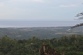
Bohol, officially the Province of Bohol, is an island province of the Philippines located in the Central Visayas region, consisting of the island itself and 75 minor surrounding islands. Its capital is Tagbilaran. With a land area of 4,821 km2 (1,861 sq mi) and a coastline 261 km (162 mi) long, Bohol is the tenth largest island of the Philippines.
The Moro Gulf is the largest gulf in the Philippines. It is located off the coast of Mindanao Island, and is part of the Celebes Sea. The gulf is one of the country's tuna fishing grounds.
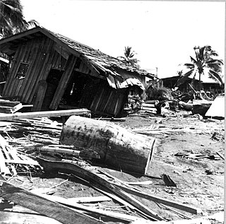
The 1976 Moro Gulf earthquake and tsunami occurred on near the islands of Mindanao and Sulu, in the Philippines. It measured 8.0 on the moment magnitude scale occurring at a depth of 20 km (12 mi). The earthquake was accompanied by a destructive tsunami that resulted in a majority of the estimated 5,000 to 8,000 fatalities. It was the deadliest and strongest earthquake in the Philippines in 58 years since the 1918 Celebes Sea earthquake.

The 2002 Mindanao earthquake struck the Philippines at 05:16 Philippine Standard Time on March 6. The world's sixth most powerful earthquake of the year, it registered a magnitude of 7.5 and was a megathrust earthquake. It originated near the Cotabato Trench, a zone of deformation situated between the Philippine Sea Plate and the Sunda Plate, and occurred very near to the Philippines' strongest earthquake for the 20th century, the 1918 Celebes Sea earthquake.
The 2010 Mindanao earthquakes occurred in the southern Philippines in the Moro Gulf. This was a complex sequence of events including three main events of magnitude 7.3 or greater on the 23rd of July, and two significant aftershocks of magnitude 6.6 on the 24th and 29th. All of these were deep focus earthquakes, at depths from 565 km (351 mi) to 634 km (394 mi). This resulted in minimal, but very widespread shaking at the surface, with a maximum intensity of IV on the PEIS scale; consequently there were no reports of casualties or damage.

The 1918 Celebes Sea earthquake occurred on August 15 at 12:18 UTC near the Moro Gulf coast of Mindanao. It had a magnitude of 8.3 on the moment magnitude scale and a maximum perceived intensity of X (Extreme) on the Mercalli intensity scale.
The Cotabato Trench is an oceanic trench in the Pacific Ocean, off the southwestern coast of Mindanao in the Philippines. Along this trench the oceanic crust of the Sunda Plate beneath the Celebes Sea is being subducted beneath the Philippines Mobile Belt. It forms part of a linked set of trenches along the western side of the Philippines formed over east-dipping subduction zones, including the Manila Trench and the Negros Trench. At its northern end the rate of convergence across this boundary is about 100 mm per year. It is a relatively young structure, forming during the late Miocene to Pliocene. This age is consistent with the estimated age of the sedimentary rocks in the accretionary wedge associated with the trench and the age of adakitic arc rocks on Mindanao thought to date the onset of subduction.
The 2019 Cotabato earthquakes were an earthquake swarm which struck the province of Cotabato on the island of Mindanao in the Philippines in October 2019. Three of these earthquakes were above 6.0 on the moment magnitude scale with a Mercalli intensity of VIII. More than 40 people have been reported dead or missing and nearly 800 were injured as a result of these events.
At 14:11 PST on December 15, 2019, the province of Davao del Sur on the island of Mindanao in the Philippines was struck by an earthquake measuring 6.8 . It had a maximum perceived intensity of VII on the Modified Mercalli Intensity Scale. At least 13 people were killed and another 210 injured.
On February 7, 2021, at 12:22 PM PST, an earthquake measuring Mww 6.0 struck Davao del Sur and Cotabato. The event registered a Modified Mercalli Intensity Scale (MMI) of VIII (Severe) with VII on the PHIVOLCS Earthquake Intensity Scale (PEIS).
Mindanao earthquake may refer to:
2023 Philippines earthquake may refer to:
This page is based on this
Wikipedia article Text is available under the
CC BY-SA 4.0 license; additional terms may apply.
Images, videos and audio are available under their respective licenses.