Related Research Articles

Broadway is a road in the U.S. state of New York. Broadway runs from State Street at Bowling Green for 13 mi (21 km) through the borough of Manhattan and 2 mi (3.2 km) through the Bronx, exiting north from New York City to run an additional 18 mi (29 km) through the Westchester County municipalities of Yonkers, Hastings-On-Hudson, Dobbs Ferry, Irvington, and Tarrytown, and terminating north of Sleepy Hollow.

A cable car is a type of cable railway used for mass transit in which rail cars are hauled by a continuously moving cable running at a constant speed. Individual cars stop and start by releasing and gripping this cable as required. Cable cars are distinct from funiculars, where the cars are permanently attached to the cable.
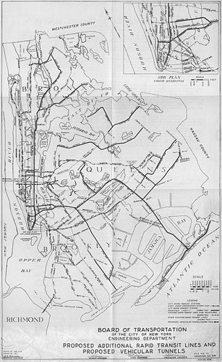
Since the opening of the original New York City Subway line in 1904, and throughout the subway's history, various official and planning agencies have proposed numerous extensions to the subway system. The first major expansion of the subway system was the Dual Contracts, a set of agreements between the City of New York and the IRT and the BRT. The system was expanded into the outer reaches of the Bronx, Brooklyn, and Queens, and it provided for the construction of important lines in Manhattan. This one expansion of the system provided for a majority of today's system.

Alfred Ely Beach was an American inventor, publisher, and patent lawyer, born in Springfield, Massachusetts. He is most known for his design of New York City's earliest subway predecessor, the Beach Pneumatic Transit. A member of the Union League of New York, he also patented a typewriter for the blind and a system for heating water with solar power.

The IRT Ninth Avenue Line, often called the Ninth Avenue Elevated or Ninth Avenue El, was the first elevated railway in New York City. It opened on July 3, 1868 as the West Side and Yonkers Patent Railway, as an experimental single-track cable-powered elevated railway from Battery Place, at the south end of Manhattan Island, northward up Greenwich Street to Cortlandt Street. It ceased operation on June 11, 1940, after it was replaced by the IND Eighth Avenue Line which had opened in 1932.

An elevated railway or elevated train is a rapid transit railway with the tracks above street level on a viaduct or other elevated structure. The railway may be broad-gauge, standard-gauge or narrow-gauge railway, light rail, monorail, or a suspension railway. Elevated railways are normally found in urban areas where there would otherwise be multiple level crossings. Usually, the tracks of elevated railways that run on steel viaducts can be seen from street level.
The BMT Jamaica Line, also known as the Broadway - Brooklyn Line is an elevated rapid transit line of the B Division of the New York City Subway, in Brooklyn and Queens, New York City, United States. It runs from the Williamsburg Bridge southeast over Broadway to East New York, Brooklyn, and then east over Fulton Street and Jamaica Avenue to Jamaica, Queens. In western Jamaica, the line goes into a tunnel, becoming the lower level of the Archer Avenue lines in central Jamaica. The J and Z trains serve the entire length of the Jamaica Line, and the M serves the line west of Myrtle Avenue.

The New York City Subway is a rapid transit system that serves four of the five boroughs of New York City, New York: the Bronx, Brooklyn, Manhattan, and Queens. Its operator is the New York City Transit Authority (NYCTA), which is controlled by the Metropolitan Transportation Authority (MTA) of New York. In 2016, an average of 5.66 million passengers used the system daily, making it the busiest rapid transit system in the United States and the seventh busiest in the world.

The Park Row station was a major elevated railway terminal constructed on the Manhattan side of the Brooklyn Bridge, across from New York City Hall and the IRT’s elevated City Hall station. It served as the terminal for BMT services operating over the Brooklyn Bridge Elevated Line from the BMT Fulton Street Line, BMT Myrtle Avenue Line and their feeders. Until the opening of the nearby Williamsburg Bridge to elevated train traffic in 1913, it was the only Manhattan station available for elevated trains from Brooklyn, and the only elevated station in Manhattan to be owned by a company other than the IRT or its predecessors.

The IRT Third Avenue Line, commonly known as the Third Avenue Elevated, Third Avenue El, or Bronx El, was an elevated railway in Manhattan and the Bronx, New York City. Originally operated by the New York Elevated Railway, an independent railway company, it was acquired by the Interborough Rapid Transit Company (IRT) and eventually became part of the New York City Subway system.

The 34th Street–Herald Square station is an underground station complex on the BMT Broadway Line and the IND Sixth Avenue Line of the New York City Subway. It is located at Herald Square in Midtown Manhattan where 34th Street, Broadway and Sixth Avenue intersect, and is served by the D, F, N, and Q trains at all times; the R train at all times except late nights; the B, M, and W trains on weekdays; and the <F> train during rush hours in the peak direction.
The New York and Putnam Railroad, nicknamed the Old Put, was a railroad line that operated between the Bronx and Brewster in New York State. It was in close proximity to the Hudson River Railroad and New York and Harlem Railroad. All three came under ownership of the New York Central system in 1894. The railroad was abandoned starting in 1958, and most of the former roadbed has been converted to rail trail use.
New York State Route 9A (NY 9A) is a state highway in the vicinity of New York City in the United States. Its southern terminus is at Battery Place near the northern end of the Brooklyn–Battery Tunnel in New York City, where it intersects with both the unsigned Interstate 478 (I-478) and FDR Drive. The northern terminus of NY 9A is at U.S. Route 9 (US 9) in Peekskill. It is predominantly an alternate route of US 9 between New York City and Peekskill; however, in New York City, it is a major route of its own as it runs along the West Side Highway and Henry Hudson Parkway. It is also one of only two signed New York State routes in Manhattan. In northern Westchester County, NY 9A follows the Briarcliff–Peekskill Parkway.

The Broadway Junction station is a New York City Subway station complex shared by the elevated BMT Canarsie Line and BMT Jamaica Line, and the underground IND Fulton Street Line. It was also served by trains of the Fulton Street Elevated until that line closed in 1956. It is located roughly at the intersection of Broadway, Fulton Street and Van Sinderen Avenue at the border of Bedford–Stuyvesant and East New York, Brooklyn. The complex is served by the A, J, and L trains at all times; the C train at all times except late nights; and the Z train during rush hours in the peak direction only.
The Third Avenue Railway System (TARS), founded 1852, was a streetcar system serving the New York City boroughs of Manhattan and the Bronx along with lower Westchester County. For a brief period of time, TARS also operated the Steinway Lines in Long Island City.

The first regularly operated subway in New York City was opened on October 27, 1904, and was operated by the Interborough Rapid Transit Company (IRT). The early IRT system consisted of a single trunk line below 96th Street in Manhattan, running under Broadway, 42nd Street, Park Avenue, and Lafayette Street. The line had three northern branches in Upper Manhattan and the Bronx, and a southern branch to Brooklyn. The system had four tracks between Brooklyn Bridge–City Hall and 96th Street, allowing for local and express service. The original line and early extensions consisted of:

Dey Street is a short street in Lower Manhattan, in New York City. It passes the west side of the World Trade Center site and the World Trade Center Transportation Hub. It runs for one block between Church Street and Broadway. It originally ran to West Street, but the western reaches were demolished to make way for the World Trade Center in the late 1960s. It now extends to Greenwich Street. 15 Dey Street is the site of the first transcontinental telephone call.
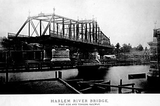
The Putnam Bridge was a swing bridge that spanned the Harlem River and the adjacent tracks of the New York Central Railroad in New York City. The bridge connected Harlem in Manhattan to Concourse, near the current location of Yankee Stadium, in the Bronx. It carried two tracks of the New York and Putnam Railroad, and later the 9th Avenue elevated line of the Interborough Rapid Transit Company (IRT), as well as two pedestrian walkways outside the superstructure.
The Dey Street station was the original southern terminus of the West Side and Yonkers Patent Railway, the first elevated railway in New York City and the United States.
References
- ↑ "The 9th Avenue Elevated-Polo Grounds Shuttle". nycsubway.org. Retrieved November 21, 2022.
- ↑ "The Elevated Broadway Railroad Scheme". New York Herald. No. 11, 532. March 27, 1868. p. 6. Retrieved November 21, 2022.
- ↑ "New York Elevated". Mid-Continent Railway Museum. April 8, 2006. Retrieved November 21, 2022.
| | This New York City transportation–related article is a stub. You can help Wikipedia by expanding it. |