
Yarmouth is a town in Cumberland County, Maine, United States, twelve miles north of the state's largest city, Portland. When originally settled in 1636, as North Yarmouth, it was part of the Massachusetts Bay Colony, and remained part of its subsequent incarnations for 213 years. In 1849, twenty-nine years after Maine's admittance to the Union as the twenty-third state, it was incorporated as the Town of Yarmouth.
The historical buildings and structures of Yarmouth, Maine, represent a variety of building styles and usages, largely based on its past as home to almost sixty mills over a period of roughly 250 years. These mills include that of grain, lumber, pulp and cotton. Additionally, almost three hundred vessels were launched by Yarmouth's shipyards in the century between 1790 and 1890, and the homes of master shipwrights and ship captains can still be found throughout the town.
Pleasant Street is a historic street in Yarmouth, Maine, United States. It was formerly part of the Atlantic Highway, a precursor to U.S. Route 1. It connects to Lafayette Street, part of today's Maine State Route 88, at Pleasant Street’s southern and northern ends. It has existed since at least 1761, which is when a milestone was placed on the street, on the order of Benjamin Franklin, due to its being on the King's Highway, to denote its distance from Boston, Massachusetts. As part of his duties, Franklin conducted inspections of the roads that were used for delivering mail. One method of charging for mail service was by mileage, so Franklin invented an odometer to measure mileage more accurately. The King's Highway, as a result, morphed into the Post Road.

Main Street is a historic street in Yarmouth, Maine, United States. It is part of the 18-mile-long (29 km) State Route 115 (SR 115), the eastern terminus of which is in Yarmouth at the intersection of Marina Road and Lafayette Street (SR 88), at Yarmouth Harbor in the Lower Falls area. Its western end is a merging with Walnut Hill Road in North Yarmouth, at which point SR 115 continues west.
Nathaniel Foster was a noted 18th- and 19th-century American potter and merchant.

Yarmouth Marina is a natural harbor and estuary of Casco Bay, and is located adjacent to the town of Yarmouth, Maine, United States. It is situated on the Royal River, around 0.5 miles (0.80 km) southeast of the town center, in an area known as Lower Falls. Today it functions solely as a marina.
Bridge Street is a historic street in Yarmouth, Maine, United States. It runs for about 0.36 miles (0.58 km) from Willow Street in the north to the town's Main Street, State Route 115, in the south. The street's elevation is around 75 feet (23 m) at each end, while its middle section, at its crossing of the Royal River, is around 13 feet (4.0 m), a drop of around 62 feet (19 m).
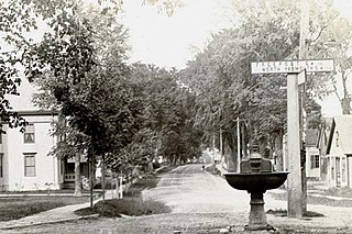
Elm Street is a prominent street in Yarmouth, Maine, United States. It runs for about 2.7 miles (4.3 km) from North Road in the north to Portland Street in the south. The street's addresses are split between "West Elm Street" and "East Elm Street", the transition occurring at Main Street in the Upper Village. Several of its buildings are homes dating to the late 18th and early 19th centuries.

Portland Street is a historic street in Yarmouth, Maine, United States. It runs for about 1.25 miles (2.01 km) from the town's Main Street, State Route 115, in the north to its merge with Middle Road in the south. It is so named because it leads to Portland, the state's largest city, after linking up with State Route 9 in Falmouth, Maine.
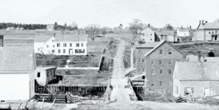
The First Falls are the first of four waterfalls in Yarmouth, Maine, United States. They are located on the Royal River, approximately a mile from its mouth with inner Casco Bay at Yarmouth Harbor and around 0.35 miles (0.56 km) downstream of the Second Falls. The river appealed to settlers because its 45-foot rise in close proximity to navigable water each provided potential waterpower sites. As such, each of the four falls was used to power 57 mills between 1674 and the mid-20th century.
The Johnathan True House is a historic home at 43 East Main Street in the Lower Falls area of Yarmouth, Maine. Built in 1780, before Yarmouth's secession from North Yarmouth, it is one of the oldest surviving buildings in the town. Between 1780 and the turn of the 19th century, Lower Falls saw an increase in its population after early settlers gradually moved inland from the area around the Meetinghouse under the Ledge on Gilman Road.
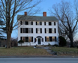
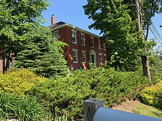
51 East Main Street, also known as the William R. Stockbridge House, is a historic home in Yarmouth, Maine. It was built in 1810, on today's State Route 88, before Yarmouth's secession from North Yarmouth. Its original owner was merchant William Stockbridge.
Lebbeus Bailey was a noted American clockmaker, prominent in the late 18th and early 19th centuries. After setting up his first business in Massachusetts, he came to prominence after moving to North Yarmouth in today's Maine, where he made clocks, sleigh bells and jewelry.
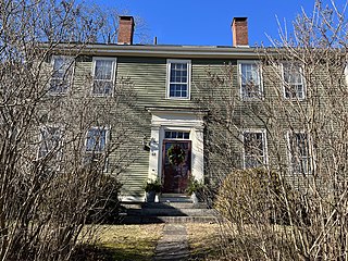
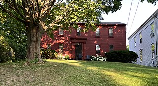
68 East Main Street is a historic home in Yarmouth, Maine, United States. It was built in 1785, when the town was part of North Yarmouth, around seventy years after the third, and earliest permanent, settlement of the town.

Hose No. 2 is a former fire station in the Lower Falls area of Yarmouth, Maine, United States. Built around 1889, seven years before the town's first fire hydrants were installed, it stands in a wedge-shaped plot of land separating Main Street and Marina Road at what was formerly known as Staples Hill. By 1901, the town had "two hose companies of fifteen men each" and a hook and ladder company of ten men. A system of fire alarms, consisting of eight boxes, were in the process of being installed.
Ammi Storer was an American merchant. He was prominent in today's Yarmouth, Maine, where a street is now named for him. He also worked in Boston, Massachusetts.

Church Street is a historic street in Yarmouth, Maine, United States. It runs for about 425 feet (142 yd) from West Elm Street in the east to Hillside Street in the west. It was one of the first streets laid out after the town's population moved inland from the Broad Cove area in the 19th century. Several of its buildings are homes dating to the late 18th and early 19th centuries.

Upper Village is the colloquial name for the western end of Main Street in Yarmouth, Maine, centered around its intersection with Elm Street. It is also known as the Corner.
Lower Falls is the colloquial name for the eastern end of Main Street, and part of East Main Street, in Yarmouth, Maine, centered around Main Street’s intersection with Portland Street. It is also known as Falls Village or The Falls.

Staples Hill is a historical section of Main Street in Yarmouth, Maine. It is located, in what is known as Lower Falls, at Main Street's split with Marina Road. Main Street continues on, down a substantial hill, to First Falls, while Marina Road leads, in a similar fashion, toward Yarmouth Marina, where ships were built between the late 18th and late 19th centuries. Today, both roads join State Route 88 around 450 feet (140 m) apart; historically, however, they provided access to the harbor from the town. The section of Route 88 between the intersections was formerly known as Grantville.

