Related Research Articles

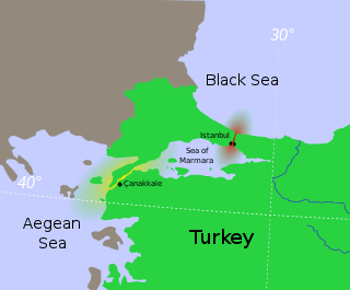
The Sea of Marmara, also known as the Marmara Sea, is a small inland sea located entirely within the borders of Turkey. It connects the Black Sea to the Aegean Sea via the Bosporus and Dardanelles straits, separating Turkey’s European and Asian sides. It has an area of 11,350 km2 (4,380 sq mi), and its dimensions are 280 km × 80 km. Its greatest depth is 1,370 m (4,490 ft).

Year 542 (DXLII) was a common year starting on Wednesday of the Julian calendar. From this year forward, the appointment of particular Roman consuls was abandoned and the office was merged with that of Byzantine emperor. Thus, the consular year dating was abandoned in practice, even though it formally remained until the end of the 9th century. The denomination 542 for this year has been used since the early medieval period, when the Anno Domini calendar era became the prevalent method in Europe for naming years.
Year 551 (DLI) was a common year starting on Sunday of the Julian calendar. The denomination 551 for this year has been used since the early medieval period, when the Anno Domini calendar era became the prevalent method in Europe for naming years.

On 17 August 1999, a catastrophic magnitude 7.6 earthquake struck the Kocaeli Province of Turkey, causing monumental damage and between 17,127 and 18,373 deaths. Named for the quake’s proximity to the northwestern city of İzmit, the earthquake is also commonly referred to as the 17 August Earthquake or the 1999 Gölcük Earthquake. The earthquake occurred at 03:01 local time at a shallow depth of 15 km. A maximum Mercalli intensity of X (Extreme) was observed. The earthquake lasted for 37 seconds, causing seismic damage and is widely remembered as one of the deadliest natural disasters in modern Turkish history.

The 1509 Constantinople earthquake or historically Kıyamet-i Sugra occurred in the Sea of Marmara on 10 September 1509 at about 22:00. The earthquake had an estimated magnitude of 7.2 ± 0.3 on the surface-wave magnitude scale. A tsunami and 45 days of aftershocks followed the earthquake. The death toll of this earthquake is poorly known; estimates range between 1,000 and 13,000.
The 426 BC Malian Gulf tsunami devastated the coasts of the Malian and Euboean Gulfs, Greece, in the summer of 426 BC. Thucydides inquired into its causes, and concluded that the tsunami must have been caused by an earthquake. He was thus historically the first known to correctly interpret the cause of a tsunami as a preceding geological event. Herodotus, in contrast, had attributed the Potidaea tsunami to the divine wrath of Poseidon.

The 1976 Moro Gulf earthquake and tsunami took place on August 17, 1976, at 00:11 local time near the islands of Mindanao and Sulu, in the Philippines. Its magnitude was calculated as being as high as 8.0 on the moment magnitude scale.

A devastating earthquake known in scientific literature as the Earthquake of 749 struck on January 18, 749, in areas of the Umayyad Caliphate, with the epicenter in Galilee. The most severely affected areas were parts of Palestine and western Transjordan. The cities of Tiberias, Beit She'an, Pella, Gadara, and Hippos were largely destroyed while many other cities across the Levant were heavily damaged. The casualties numbered in the tens of thousands.
The 1932 Jalisco earthquakes began on June 3 at 10:36 UTC with a megathrust event that registered 8.1 on the moment magnitude scale. With a maximum perceived intensity of X (Extreme) on the Mercalli intensity scale, at least 400 deaths were caused in Mexico and neighboring Guatemala. It was the first of a series of seismic events that affected parts of western Mexico during the month of June 1932, all reaching magnitude 7 or greater.
The 1901 Black Sea earthquakewas a 7.2 magnitude earthquake, the most powerful earthquake ever recorded in the Black Sea. The earthquake epicenter was located in the east of Cape Kaliakra, 30 kilometres (19 mi) off northeast coast of Bulgaria. The mainshock occurred at a depth of 15 km (9.3 mi) and generated a 4–5-metre (13–16 ft) high tsunami that devastated the coastal areas of Romania and Bulgaria. In Romania, the earthquake was felt not only throughout Northern Dobruja, but also in Oltenia and Muntenia, and even in southern Moldova.
The 991 Damascus earthquake took place in the city of Damascus on 5 April, 991.
The 957 Caspian Sea earthquake took place in the Caspian Sea and its vicinity in 957.
The 881 Acre earthquake took place in the vicinity of Acre in 881. Alexandria was reportedly affected by the same earthquake.
The 859 Syrian coast earthquake affected the Mediterranean coast of Syria in the year 859 or 860 CE. It caused almost the complete destruction of Latakia and Jableh, major damage at Antioch and led to many deaths.
The 740 Constantinople earthquake took place on 26 October, 740, in the vicinity of Constantinople and the Sea of Marmara.
The 554 Anatolia earthquake took place on August 15, 554 in the southwest coasts of Anatolia. It affected the Güllük Gulf, and the island of Kos.
The 551 Malian Gulf earthquake took place in the Spring of 551 in the vicinity of the Malian Gulf. It affected the cities of Echinus and Tarphe.

The 1766 Istanbul earthquake was a strong earthquake with epicenter in the eastern part of the Sea of Marmara, in the Çınarcık Basin which occurred in the early hours of Thursday morning, 22 May 1766. The earthquake had an estimated magnitude of 7.1 on the surface wave magnitude scale, and caused effects in a vast area extending from Izmit to Rodosto. In this area, the earthquake was followed by a tsunami which caused significant damage. The earthquake of 1766 was the last major earthquake to rock Constantinople because of a rupture of the North Anatolian Fault in the Marmara region.
The area around Constantinople was affected by a major earthquake in AD 447. It caused serious damage to the recently completed Theodosian Walls in Constantinople, destroying 57 towers and large stretches of the walls. The historical records contain no mention of casualties directly associated with this earthquake, although many thousands of people were reported to have died in the aftermath due to starvation and a "noxious smell".
The 1944 Gulf of Edremit–Ayvacik earthquake occurred on October 6 at 05:34:48 local time in Balıkesir Province, Turkey. It measured 6.7 on the moment magnitude scale (Mw ) and occurred at a depth of 15 km (9 mi). The normal-faulting event had a maximum MSK-64 intensity of IX. A total of 73 people died and 275 others were injured.