Related Research Articles

Lamu or Lamu Town is a small town on Lamu Island, which in turn is a part of the Lamu Archipelago in Kenya. Situated 341 kilometres (212 mi) by road northeast of Mombasa that ends at Mokowe Jetty, from where the sea channel has to be crossed to reach Lamu Island. It is the headquarter of Lamu County and a UNESCO World Heritage Site.
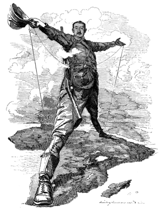
The Cape to Cairo Railway was an unfinished project to create a railway line crossing from southern to northern Africa. It would have been the largest, and most important, railway of the continent. It was planned as a link between Cape Town in South Africa and Port Said in Egypt.

Isiolo is a town in Isiolo County, of which it is the capital. It is located in the upper eastern region of Kenya and is geographically considered the center of the country Kenya. It lies 285 kilometers north of the capital Nairobi. The town grew around the local military camps. Much of the population consists of Somali, Borana and Ameru community. The town has an estimated population of 78,250, most of them living around the outskirts of the town. Like most African cities, there has been a steady increase in the urban population in recent years, especially moving from as far as Moyale, Marsabit and Mandera. Isiolo town is also becoming a centre of interest because of its newly acquired status as a resort city cashing in on the popular Samburu and Shaba Game reserves, which have become preferred destinations after the famed Maasai Mara. Isiolo lies along the long A2 Road, leading towards Marsabit and Moyale much further north.
Lamu County is a county in Kenya located along the North Coast of the country and is one of the six Coastal Counties in Kenya. Its capital is the town of Lamu. It borders Tana River County to the southwest, Garissa County to the north, Somalia to the northeast, and the Indian Ocean to the South.
Lamu Island is a port, city, and island just off the shore of Kenya in the Indian Ocean approximately 150 miles from Mombasa. It is a part of the East African country of Kenya. Lamu was founded in the 12th century. Lamu is one of the longest-established and best-preserved remaining settlements of the Swahili tradition in east Africa that remains today. The island has continually been inhabited for over seven hundred years, and continues to be an important center in eastern Africa.
Railway stations in Kenya include:
Railway stations in Uganda include:
Kenya Ports Authority (KPA) is a state corporation with the responsibility to "maintain, operate, improve and regulate all scheduled seaports" on the Indian Ocean coastline of Kenya, including principally Kilindini Harbour at Mombasa. Other KPA ports include Lamu, Malindi, Kilifi, Mtwapa, Kiunga, Shimoni, Funzi and Vanga.
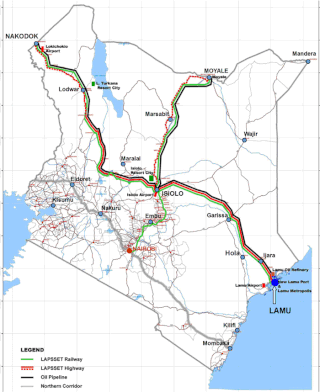
Lamu Port-South Sudan-Ethiopia-Transport (LAPSSET) Corridor project, also known as Lamu corridor is a transport and infrastructure project in Kenya that, when complete, will be the country's second transport corridor. Kenya's other transport corridor is the Northern Corridor, which links Mombasa to Uganda, passing through Nairobi and much of the Northern Rift. Some basic LAPSSET infrastructure has been built. The construction of LAPSSET's main components is currently ongoing with construction of the first berth at Lamu Port completed in October 2019.. Although the project is not formally stalled, its short to medium term success looks increasingly unlikely. Insecurity and political instability in Kenya are mostly to blame for this, as are more commercially viable alternative pipeline options through Tanzania or Ethiopia. The low oil prices since 2015 also affect LAPSSET's commercial prospects.

Ethiopia–Kenya relations are bilateral relations between Ethiopia and Kenya. The two nations maintain primarily trade ties.
The Garissa–Nuno–Modogashe–Wajir Road is a road in Kenya, connecting the towns of Garissa, Nuno, Modogashe and Wajir.
Garsen–Witu–Lamu Highway is a road, under construction in Kenya, connecting the towns of Garsen,Witu and Lamu.
Kenya Crude Oil Pipeline, also Lokichar–Lamu Crude Oil Pipeline, is a proposed crude-oil pipeline in Kenya. The pipeline will originate in the oil-rich South Lokichar Basin, near the town of Lokichar, in northwest Kenya to end at Port Lamu, on the Indian Ocean. The route will remain as originally planned in the Uganda–Kenya Crude Oil Pipeline, in August 2015. The route, was proposed by Toyota Tsusho, the consultant selected by the two governments of that now-abandoned project.
Lamu–Garissa–Isiolo Road, is a road in Kenya, and is part of the Lamu-Garissa-Isiolo-Lokichar Road, which itself is a component of the Lamu Port and Lamu-Southern Sudan-Ethiopia Transport Corridor (LAPSSET) Project.
The Kenya Standard Gauge Railway (SGR) is a partially finished railway system connecting Kenya's cities. Once completed, it will link the country to the neighboring country of Uganda, and through Uganda, to South Sudan, the Democratic Republic of the Congo, Rwanda, and Burundi. There are also plans to link to Addis Ababa, in neighboring Ethiopia to the north. The first segment, between Mombasa and Nairobi, opened passenger rail service in June 2017, and freight rail service in January 2018. Other segments are under construction or planned. The new standard gauge railway, is intended to replace the old, inefficient metre-gauge railway system.

The Isiolo–Moyale Road is a road section of the A2 Road in Kenya, connecting the towns of Isiolo, Archers Post, Marsabit, and Moyale. The road is a component of the Lamu Port and Lamu-Southern Sudan-Ethiopia Transport Corridor (LAPSSET) Project. It connects Kenya to Ethiopia, its neighbor to the north.
Isiolo–Mandera Road, is a road in Kenya. It is a major transport route linking north-central Kenya to Kenya's northeast. The counties that the road traverses are generally arid, and have hitherto been undeserved. This road project is the largest and most expensive infrastructure project in northeastern Kenya since the country became independent in 1963.
The Nairobi-Addis Ababa Railway is an upcoming Standard Gauge Railway in Kenya and Ethiopia under the LAPSSET project. Conceptualized in 1975, LAPSSET was launched in 2009 under President Mwai Kibaki as part of Kenya's Vision 2030. It is also part of the East African Railway Masterplan.
The A11 road is a road in Kenya situated in the easternmost part of the country. Spanning a distance of 107 kilometers, this route connects Lamu to Kiunga, a location near the international border with Somalia. Currently, the A11 exists as an unpaved dirt road, traversing a remote and potentially challenging terrain. Despite its rugged nature, this road plays a crucial role in linking these far-flung regions and facilitating movement within the area.
References
- 1 2 3 "Kenya Roads Board" . Retrieved 2024-08-05.
- 1 2 Kenya Gazette Supplement No. 4 of 2016
- ↑ http://kenyalaw.org/kl/fileadmin/pdfdownloads/Acts/KenyaRoadsAct_No2of2007.pdf
- ↑ https://www.afdb.org/en/documents/lamu-port-south-sudan-ethiopia-transport-lapsset-corridor-project-project-appraisal-report