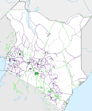
Transport in Kenya refers to the transportation structure in Kenya. The country has an extensive network of paved and unpaved roads.

Kisumu is the third-largest city in Kenya after the capital, Nairobi, and Mombasa. It is the second-largest city after Kampala in the Lake Victoria Basin. The city has a population of slightly over 600,000. The metro region, including Maseno and Ahero, has a population of 1,155,574 people according to the 2019 Kenya Population and Housing Census which was conducted by the Kenya National Bureau of Statistics.
Kisii is a municipality and urban centre in south-western Kenya and the capital of Kisii County. Kisii Town also serves as a major urban and commercial centre in the Gusii Highlands—Kisii and Nyamira counties—and the South Nyanza region and is the second largest town in formerly greater Nyanza after Kisumu City. Kisii municipality sits right at the centre of the western Kenya tourist circuit that includes the Tabaka Soapstone Carvings, Maasai Mara, Ruma National Park and part of the Lake Victoria Basin.
B1 Road is a major road in Kenya connecting Nakuru to the Ugandan border. The road can be divided into two distinct parts: Nakuru - Kisumu highway and Kisumu-Busia highway.

Ahero is a town in the city of Kisumu, the third largest city in Kenya and the second largest city, after Kampala, in the Lake Victoria Basin. It is an agriculture town in Kenya that is part of Kisumu County. The town has a retail market serving as a main trading center for food and goods coming from Kisii, Homabay, and Nandi. It hosts a town council and has an urban population of 7,891 and a total population of 61,556.

Kendu Bay is a bay and town in Kenya. The area is the part of Rachuonyo North District in Homa Bay County.
Loichangamatak is a settlement in Kenya's Rift Valley Province.
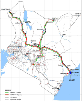
Lamu Port-South Sudan-Ethiopia-Transport (LAPSSET) Corridor project, also known as Lamu corridor is a transport and infrastructure project in Kenya that, when complete, will be the country's second transport corridor. Kenya's other transport corridor is the Northern Corridor, which links Mombasa to Uganda, passing through Nairobi and much of the Northern Rift. Some basic LAPSSET infrastructure has been built. The construction of LAPSSET's main components is currently ongoing with construction of the first berth at Lamu Port completed in October 2019.. Although the project is not formally stalled, its short to medium term success looks increasingly unlikely. Insecurity and political instability in Kenya are mostly to blame for this, as are more commercially viable alternative pipeline options through Tanzania or Ethiopia. The low oil prices since 2015 also affect LAPSSET's commercial prospects.
The Isebania–Kisii–Ahero Road is a road section of the A1 road in Kenya, connecting the towns of Isebania, Migori, Kisii and Ahero.
Isbania, also Isibania, is a town in Migori County of Kenya, at the International border with Tanzania.
Isebania, also Isibania, is a town in Tarime District, Mara Region, in northern Tanzania, at the border with Kenya.
The Kisumu–Kakamega–Webuye–Kitale Road, is a rural road in Kenya. The road links Kisumu, in Kisumu County, to the towns of Kakamega, in Kakamega County, Webuye in Bungoma County, and Kitale in Trans-Nzoia County.
The Kenya Standard Gauge Railway (SGR) is a partially finished railway system connecting Kenya's cities. Once completed, it will link the country to the neighboring country of Uganda, and through Uganda, to South Sudan, the Democratic Republic of the Congo, Rwanda, and Burundi. There are also plans to link to Addis Ababa, in neighboring Ethiopia to the north. The first segment, between Mombasa and Nairobi, opened passenger rail service in June 2017, and freight rail service in January 2018. Other segments are under construction or planned. The new standard gauge railway, is intended to replace the old, inefficient metre-gauge railway system.
The Kisumu–Chemelil–Muhoroni Road, is a road in Kenya, that links the city of Kisumu, to the towns of Miwani, Kibigori, Chemelil, all in Kisumu County, to the town of Muhoroni, also in Kisumu County. The road is sometimes referred to as the Nyanza Sugar Belt Road.
The Kakira–Kisumu Expressway, also Kenya–Uganda Highway, is a road in Uganda and Kenya, connecting the cities of Kakira and Iganga in Uganda to Busia, Malaba and Kisumu in Kenya.
The A7 road is a road in Kenya that spans 923 kilometers. It connects the Ugandan border to the port city of Mombasa, passing through Eldoret and Nairobi. The road is one of the main transportation routes in Kenya, providing an east–west connection. It also serves as a route for international traffic to and from Uganda.
The A12 road is a road in Kenya spanning a distance of 228 kilometers. It traverses the western region of the country, forming a crucial east–west route. The A12 originates at the Ugandan border in Busia and extends westward, passing through the city of Kisumu before terminating at Mau Summit. This transportation artery connects key urban centers and facilitates movement across the region, playing a role in Kenya's infrastructure network.

