
Samburu County is a county in the former Rift Valley Province, Kenya which covers an area of roughly 21,000 km2 (8,000 mi2) in northern Kenya where the Samburu, Turkana and many other tribes live. It stretches north from the Wuaso Ng'iro River to the south of Lake Turkana. According to the 2019 census, the county has a population of 310,327.
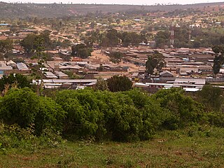
Maralal is a small hillside market town in northern Kenya, lying east of the Loroghi Plateau within Samburu County, of which it is the capital. It is the administrative headquarters of Samburu County. The town has an urban population of 31,350. The market was pioneered by Somali settlers in the 1920s.

The Ilchamus, are a Maa-speaking people living south and southeast of Lake Baringo, Kenya. They numbered approximately 32,949 people in 2019 and are closely related to the Samburu living more to the north-east in the Rift Valley Province. They are one of the smallest ethnic groups in Kenya.

Nyahururu is a town in Kenya, lying north east of Nakuru. The town derives its name from the Maasai word e-naiwurruwurr, meaning waterfall and/or windy or place of storms. It is allegedly located in Laikipia County. Despite this, Nyahururu formerly functioned as the administrative capital of Nyandarua District, before it became a county, until the headquarters was shifted to Ol Kalou. There have been calls for a reversal. The town has an urban population of 36,450. The town still continues to be a central economic power of the immediate former district of Nyandarua. For that reason, the town has strong economic ties to the two counties.
Lerata is a village in northern Kenya, between Marsabit and Shaba, Kenya. It is in an area populated by the Samburu people. Lerata is located along the A2 road, not far north of Archers Post. The C79 road towards Maralal and Baragoi has its eastern end in Lerata. Lerata is part of the Waso East ward in Samburu East Constituency and Samburu County Council of Samburu County.

Isiolo is a town in Isiolo County, of which it is the capital. It is located in the upper eastern region of Kenya and is geographically considered the center of the country Kenya. It lies 285 kilometers north of the capital Nairobi. The town grew around the local military camps. Much of the population consists of Somali, Borana and Ameru community. The town has an estimated population of 78,250, most of them living around the outskirts of the town. Like most African cities, there has been a steady increase in the urban population in recent years, especially moving from as far as Moyale, Marsabit and Mandera. Isiolo town is also becoming a centre of interest because of its newly acquired status as a resort city cashing in on the popular Samburu and Shaba Game reserves, which have become preferred destinations after the famed Maasai Mara. Isiolo lies along the long A2 Road, leading towards Marsabit and Moyale much further north.

Baragoi is a market town in Kenya, lying north of Maralal and east of the Suguta Valley. It is located in Samburu County. The entire Baragoi division has a population of nearly 20,000 comprising mostly people from the Samburu and Turkana tribes.
Marsabit County is a county in Kenya. Covering a surface area of 66,923.1 square kilometres. Marsabit is the second largest county by size in Kenya after Turkana county which has an area of 71,597.8 km2. Its capital is Marsabit and its largest town is Moyale. According to the 2019 census, the county has a population of 459,785. It is bordered to the North by Ethiopia, to the West by Turkana County to the South by Samburu County and Isiolo County, and to the East by Wajir County.

Local authorities in Kenya are the bodies controlling local governance in urban areas in Kenya.
The districts of Kenya were divided into 262 divisions (matarafa). Divisions of Kenya were further subdivided into locations. Today's counties of Kenya are based on the merging of some of the districts on this list and since the divisions are one level under the districts they are now the sub-counties. This is because Kenya recently changed its constitution and 47 Counties emerged. Here are the divisions listed below, by district :
South Horr is a settlement in Kenya's former Rift Valley Province. It is located in Laisamis Constituency, of Marsabit County. The A4 Road from Maralal and Baragoi to Loyangalani passes through the village.
Rumuruti is a town in Laikipia County in Kenya's former Rift Valley Province. It is approximately 40 kilometers due north of Nyahururu, on the Nyahururu-Maralal road (A4). Despite being smaller than either Nanyuki or Nyahururu, which are on the Southeastern and Southwestern corners of Laikipia respectively, its central location meant that it was selected as the administrative headquarters of the new County government in 2013. In 2013 a local business launched a plan to build a 200 million Kenya shilling meat processing facility in the town.
Kisima Airport is an airport in Kenya.
In November 2012, a series of ethnic clashes between the Samburu and Turkana tribes of Kenya's Samburu County resulted in the deaths of at least 46 people including police officers sent to quell the violence.
Samburu District was a district in the Rift Valley Province of Kenya. It covered an area of roughly 21,000 km2 (8,000 mi2) in northern Kenya where the Samburu tribe live. The district had a population of 143,547 in the 1999 census. It stretched north from the Wuaso Ng'iro River to the south of Lake Turkana and also includes Mount Kulal which lies just east of Lake Turkana.
Isaac Lenaola is a Kenyan lawyer and judge, who has served as a Justice of the Supreme Court of Kenya, since 28 October 2016.
Kisima is a small village in Samburu County in northwestern Kenya, southeast of the town of Maralal. It lies next to Lake Kisima in the eastern part of the Loroghi Plateau. The village is most notable as the location of Kisima Airport, which serves both Kisima and Maralal.
Lengusaka is a small village in Northern Kenya located between Archers Post and Wamba on the C37/C38 road that leads to Maralal, the County Capital, in the Samburu County Highlands. The Samburu people practice pastoralism. Lengusaka is primarily inhabited by shopkeepers who serve the nearby pastoralist community. The seasonal Lengusaka River marks the start of the town on the Archer’s Post Side, and on the Wamba side of town it currently ends a few hundred meters down the road at the Lengusaka Hill.
The Northern Acacia–Commiphora bushlands and thickets are a tropical grasslands, savannas and shrublands ecoregion in eastern Africa. The ecoregion is mostly located in Kenya, extending north into southeastern South Sudan, northeastern Uganda and southwestern Ethiopia and south into Tanzania along the Kenya-Tanzania border.
The mission of the Kenya Army Engineers Brigade is to support the Kenya Army in defence of the country against external aggression and to aid civil authority in humanitarian or civic projects.
