Related Research Articles

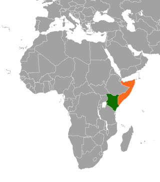
The Geography of Kenya is diverse, varying amongst its 47 counties. Kenya has a coastline on the Indian Ocean, which contains swamps of East African mangroves. Inland are broad plains and numerous hills. Kenya borders South Sudan to the northwest, Uganda to the west, Somalia to the east, Tanzania to the south, and Ethiopia to the north. Kenya currently faces border disputes with South Sudan over the Ilemi Triangle and with Somalia over Jubbaland where, if the Somalian Government gives it up, it could be a new part of Kenya, which would bring the total land area of Kenya to approximately 692,939 km2.
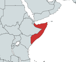
Somalia is a country located in the Horn of Africa which officially consists of the intra-46th meridian east territory, the seven federal member states, namely Galmudug, Hirshabelle, Jubaland, South West, Puntland, and the municipality of Benadir. It is bordered by Ethiopia to the west, the Gulf of Aden to the north, the Somali Sea and Guardafui Channel to the east, and Kenya to the southwest. With a land area of 637,657 square kilometers, Somalia's terrain consists mainly of plateaus, plains and highlands. Its coastline is more than 3,333 kilometers in length, the longest of mainland Africa. It has been described as being roughly shaped "like a tilted number seven".
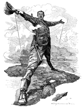
The Cape to Cairo Railway was an unfinished project to create a railway line crossing from southern to northern Africa. It would have been the largest, and most important, railway of the continent. It was planned as a link between Cape Town in South Africa and Port Said in Egypt.

The Lamu Archipelago is located in the Indian Ocean close to the northern coast of Kenya, to which it belongs. The islands lie between the towns of Lamu and Kiunga, near the Coast Province. It is a part of Lamu District.

Lamu County is a county in Kenya located along the North Coast of the country and is one of the six Coastal Counties in Kenya. Its capital is the town of Lamu. It borders Tana River County to the southwest, Garissa County to the north, Somalia to the northeast, and the Indian Ocean to the South.

Garissa County is an administrative county in Kenya. It is located in Eastern Kenya bordering Somalia to the East, Wajir County and Isiolo County to the North, Tana River County to the West and Lamu County to the South. Its capital and largest urban area is Garissa.
Ijara was a former administrative district in the North Eastern Province of Kenya. On May 20, 2000, it was carved out from the larger Garissa District. It covered an area of 11,332 km2 and, according to the population census of 1999, had a population of 62,571. It bordered Garissa District to the north, Lamu District to the south, Tana River District to the west, and Somalia to the northeast. The district had one local authority, Ijara county council, and one constituency, Ijara Constituency. In 2010, it was amalgamated with Garissa County.

The Bajuni people are a Bantu ethnic group who live primarily in the Bajuni Islands of Somalia and coastal areas between the port city of Kismayo and the city of Mombasa in Kenya. Many relocated from Somalia to Kenya due to war with the Orma, who drove them out from their ancestral territory.
The Kenya Navy is the naval branch of the Kenya Defence Forces. It is headquartered in Mombasa.
The Aweer are a Cushitic-speaking ethnic group inhabiting the Coast Province in southeastern Kenya. They are indigenous foragers, traditionally subsisting on hunting, gathering, and collecting honey.
Kenya Ports Authority (KPA) is a state corporation with the responsibility to "maintain, operate, improve and regulate all scheduled seaports" on the Indian Ocean coastline of Kenya, including principally Kilindini Harbour at Mombasa. Other KPA ports include Lamu, Malindi, Kilifi, Mtwapa, Kiunga, Shimoni, Funzi and Vanga.
Ashuwei is a Bajuni sea settlement in Kenya's Lamu County.
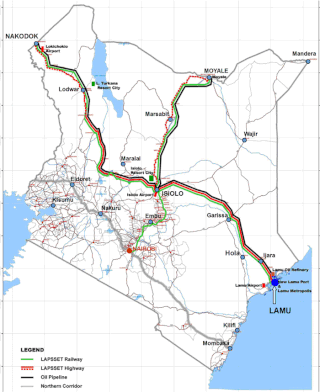
Lamu Port-South Sudan-Ethiopia-Transport (LAPSSET) Corridor project, also known as Lamu corridor is a transport and infrastructure project in Kenya that, when complete, will be the country's second transport corridor. Kenya's other transport corridor is the Northern Corridor, which links Mombasa to Uganda, passing through Nairobi and much of the Northern Rift. Some basic LAPSSET infrastructure has been built. The construction of LAPSSET's main components is currently ongoing with construction of the first berth at Lamu Port completed in October 2019.. Although the project is not formally stalled, its short to medium term success looks increasingly unlikely. Insecurity and political instability in Kenya are mostly to blame for this, as are more commercially viable alternative pipeline options through Tanzania or Ethiopia. The low oil prices since 2015 also affect LAPSSET's commercial prospects.
The Somali–Kenyan conflict has been an issue within Kenya since the colonial period. Problems have ranged from skirmishes between the two communities and have led to terrorist attacks, police harassment, extortion, home invasions, physical violence, and massacres perpetrated against Somalis and Kenyans.
The Northern Monsoon Current coast is a marine ecoregion along the eastern coast of Africa. It extends along a portion of the coasts of Somalia and Kenya, from south of Lamu in Kenya to north of Mogadishu in Somalia. It adjoins the Central Somali coast ecoregion to the north, and the East African coral coast ecoregion to the south.
Skyward Express,, is a private airline operating in Kenya. It serves local destinations, from its two operations bases at Wilson Airport for passengers and Jomo Kenyatta International Airport for cargo. Both airports are located in Nairobi, the Kenyan capital city.
The M9 road traverses the northwest region of Malawi, stretching from the vicinity of Mzimba to the Tanzanian border at Zepetia. This north-south route offers a link to the country's highlands but bypasses major urban centers. However, the majority of the route is unpaved, consisting of dirt roads that wind through the picturesque landscape.
The A7 road is a road in Kenya that runs along the Indian Ocean coastline. It spans 428 kilometers, starting at the Tanzanian border and passing through the port city of Mombasa before ending in Lamu. The road connects various locations along the coast.
The A7 road is a road in Kenya that spans 923 kilometers. It connects the Ugandan border to the port city of Mombasa, passing through Eldoret and Nairobi. The road is one of the main transportation routes in Kenya, providing an east–west connection. It also serves as a route for international traffic to and from Uganda.
The A10 road is a road in Kenya stretching a diagonal trajectory from Lokichar in the northwest to the port city of Lamu in the southeast, covering a planned distance of 970 kilometers. Currently, the route is in various stages of development, with certain sections yet to be constructed. As a key development axis, the A10 has the potential to play a role in connecting disparate regions and fostering economic growth. However, its full realization requires further infrastructure development to complete the envisioned route.