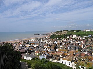
Hastings is a seaside town and borough in East Sussex on the south coast of England, 24 mi (39 km) east of Lewes and 53 mi (85 km) south east of London. The town gives its name to the Battle of Hastings, which took place 8 mi (13 km) to the north-west at Senlac Hill in 1066. It later became one of the medieval Cinque Ports. In the 19th century, it was a popular seaside resort, as the railway allowed tourists and visitors to reach the town. Today, Hastings is a fishing port with the UK's largest beach-based fishing fleet. It has an estimated population of 91,100 as of 2021.

East Sussex is a ceremonial county in South East England. It is bordered by Kent to the north-east, West Sussex to the west, Surrey to the north-west, and the English Channel to the south. The largest settlement is the city of Brighton and Hove, and the county town is Lewes.

Rother is a local government district in East Sussex, England. Its council is based in Bexhill-on-Sea. The district is named after the River Rother which flows within its boundaries.
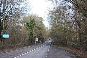
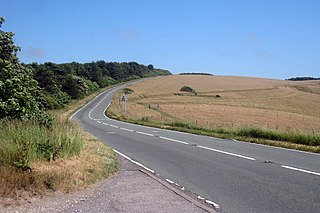
The A21 is a trunk road in Southern England, one of several which connect London and various commuter towns to the south coast. It provides a link to Hastings, East Sussex and parts of Kent. Half of the distance covered is over gently undulating terrain, with some hills and bends. Often traffic is slow-moving, particularly on weekdays on the short single carriageway stretches; and in summer with holiday traffic. Because of this, people have described the A21 as "a joke" and businesspeople have been reported to "hate coming down the A21". There have been many proposals to upgrade parts of the A21 in response to this.
The A259 is a road on the south coast of England passing through Hampshire, West Sussex, East Sussex, and Kent, and is the longest Zone 2 A road in Great Britain. The main part of the road connects Brighton, Eastbourne, Hastings, Rye, and Folkestone.

Battle is a town and civil parish in the district of Rother in East Sussex, England. It lies 50 miles (80 km) south-east of London, 27 miles (43 km) east of Brighton and 20 miles (32 km) east of Lewes. Hastings is to the south-east and Bexhill-on-Sea to the south. Battle is in the designated High Weald Area of Outstanding Natural Beauty. The parish population was 6,048 according to the 2001 census, increasing to 6,673 with the 2011 Census. Battle is near the site of, and named after, the Battle of Hastings, where William, Duke of Normandy, defeated King Harold II to become William I of England in 1066.

The Hastings line is a secondary railway line in Kent and East Sussex, England, linking Hastings with the main town of Tunbridge Wells, and London via Tonbridge and Sevenoaks. Although primarily carrying passengers, the railway also serves a gypsum mine which is a source of freight traffic. Southeastern Trains operates passenger trains on the line, and it is one of their busiest lines.

Mountfield is a village and civil parish in the Rother district of East Sussex, England, and three miles (5 km) north-west of Battle. It is mentioned in the Domesday Book.

Route 117 is a 31.0718-mile-long (50.0052 km) east–west state highway in Massachusetts, running from Route 12 in Leominster in northeast Worcester County to U.S. Route 20 in Waltham in central Middlesex County.

State Route 35 is a primary state highway in the U.S. state of Virginia. The state highway runs 48.71 miles (78.39 km) from the North Carolina state line near Boykins, where the highway continues as North Carolina Highway 35, north to SR 605 and SR 622 in Templeton. SR 35 is the main north–south highway of Southampton County; the highway also connects U.S. Route 58 in Courtland with Interstate 95 (I-95) and US 301 at Templeton south of Petersburg.

The A271 road is a main road through East Sussex, England. It runs east–west from the A2100 in Battle to the A22 and A267 at Horsebridge near Hailsham.

U.S. Highway 6 (US-6) in the U.S. state of Nebraska is a United States Numbered Highway which goes from the Colorado border west of Imperial in the west to the Iowa border in the east at Omaha. Significant portions of the highway are concurrent with other highways, most significantly, US-34 between Culbertson and Hastings. Also, from Milford east to the Iowa border, the highway is closely paralleled by Interstate 80 (I-80). Large portions of the route parallel the Chicago, Burlington and Quincy Railroad.
Baldslow is a suburb in the north of Hastings, East Sussex, England. It is sometimes considered part of Conquest as Bohemia and Silverhill.

Hollington is a council estate and local government ward in the northwest of Hastings, in the Hastings district, in the county of East Sussex, England. The area lies next to Baldslow, Ashdown, North and Conquest, and less than five miles southeast of Battle, East Sussex, the home of Battle Abbey, which commemorates the victory of William the Conqueror at the Battle of Hastings in 1066.

Silverhill is a suburb and local government ward of Hastings, East Sussex, England. It has a central location within the town, where the A21 meets the B2159 road.
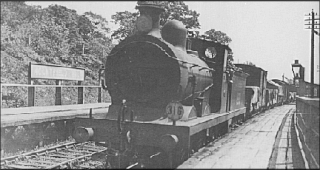
Mountfield Halt was situated on the Hastings Line between Robertsbridge and Battle. It opened in 1923 and was closed on 6 October 1969. Both platforms were built of sleepers. The station stood just east of Battle Road (A2100) level crossing.

St Leonards-on-Sea Congregational Church is a former Congregational church in St Leonards-on-Sea, part of the town and borough of Hastings in East Sussex, England. Considered "one of the most ambitious Nonconformist buildings in Sussex", the sandstone building of 1863 forms a significant landmark on one of the Victorian resort's main roads—despite the loss of its copper spire in the Great Storm of 1987. Unlike most churches of its denomination, it did not join the United Reformed Church when that denomination was formed in 1972. It fell out of religious use in 2008 and had stood empty and was at risk of demolition. English Heritage has listed the building at Grade II for its architectural and historical importance. Bought by a new owner in 2012 it was almost completely renovated, but was then sold again in 2019. The new owner plans to open the church to the public as an arts and antiques centre with a cafe in the tower.

Cripps Corner is a village in the civil parish of Ewhurst and the Rother district of East Sussex, England. It is in the High Weald Area of Outstanding Natural Beauty, and on a southern ridge of the valley of the River Rother which flows through Bodiam, 2.5 miles (4 km) to the north of Cripps Corner.

Vinehall Street, is a linear settlement in the civil parishes of Mountfield and Whatlington, and the Rother district of East Sussex, England. Vinehall School is situated in Vinehill Street.