
The M1 motorway connects London to Leeds, where it joins the A1(M) near Aberford, to connect to Newcastle. It was the first inter-urban motorway to be completed in the UK; the first motorway in the country was the Preston Bypass, which later became part of the M6.
The A1, also known as the Great North Road, is the longest numbered road in the United Kingdom, at 410 miles (660 km). It connects London, the capital of England, with Edinburgh, the capital of Scotland. The numbering system for A-roads, devised in the early 1920s, was based around patterns of roads radiating from two hubs at London and Edinburgh. The first number in the system, A1, was given to the most important part of that system: the road from London to Edinburgh, joining the two central points of the system and linking the UK's (then) two mainland capital cities. It passes through or near north London, Hatfield, Stevenage, Baldock, Biggleswade, Peterborough, Stamford, Grantham, Newark-on-Trent, Retford, Doncaster, Pontefract, York, Wetherby, Ripon, Darlington, Durham, Gateshead, Newcastle upon Tyne, Morpeth, Alnwick, Berwick-upon-Tweed, Dunbar, Haddington, Musselburgh, and east Edinburgh.

In Great Britain, there is a numbering scheme used to classify and identify all roads. Each road is given a single letter and a subsequent number. Though this scheme was introduced merely to simplify funding allocations, it soon became used on maps and as a method of navigation. There are two sub-schemes in use: one for motorways, and another for non-motorway roads.

The A14 is a major trunk road in England, running 127 miles (204 km) from Catthorpe Interchange, a major intersection at the southern end of the M6 and junction 19 of the M1 in Leicestershire to the Port of Felixstowe, Suffolk. The road forms part of the unsigned Euroroutes E24 and E30. It is the busiest shipping lane in East Anglia carrying anything from cars to large amounts of cargo between the UK and Mainland Europe.

National Development Plan is the title given by the Irish Government to a scheme of organised large-scale expenditure on (mainly) national infrastructure. The first five-year plan ran from 1988 to 1993, the second was a six-year plan from 1994 to 1999 and the third ran as a seven-year plan from 2000 to 2006. A fourth National Development Plan ran from 2007 to 2011. The main elements of the third plan were the development of a national motorway network between the major cities in Ireland. The upgrading of the rail network was a secondary scheme.

The Edinburgh City Bypass, designated as A720, is one of the most important trunk roads in Scotland. Circling around the south of Edinburgh, as the equivalent of a ring road for the coastal city, it links together the A1 towards north-east England, the A702 towards north-west England, the M8 through the Central Belt towards Glasgow, the A7 through south-east Scotland and north-west England as well as the A8 leading to the M9 for Stirling and the Queensferry Crossing.

The M1 is a motorway in Northern Ireland. It is the longest motorway in Northern Ireland and runs for 38 miles (61 km) from Belfast to Dungannon through County Antrim, County Down, County Armagh and County Tyrone. It forms part of the route via the A1 in Northern Ireland between Belfast and Dublin as well as being a part of the unsigned European E01 and E18 routes.

The A9 motorway is a motorway in the Netherlands. The motorway starts off by going from the A1 at Diemen to the A2 at junction 'Holendrecht'.
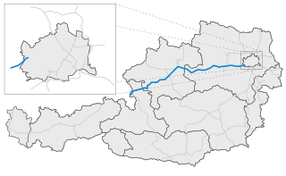
The West Autobahn (A1) was the first motorway (Autobahn) to be built in Austria, originating from plans drawn up for the so-called Reichsautobahn system. Completed in 1967, today it runs from the outskirts of Vienna via Linz to Salzburg, where it joins the German Bundesautobahn 8 at the Walserberg border crossing.

The motorways in North Macedonia are called avtopat and the name, like its translation in most languages, simply means auto road.

European route E73 forms part of the United Nations International E-road network, connecting Hungary and eastern Croatia to Bosnia and Herzegovina and the Adriatic Sea in the vicinity of the port of Ploče. This 679-kilometre (422 mi) route is also designated as the Pan-European Corridor Vc, a branch of the fifth Pan-European corridor. The route largely consists of two-lane roads with at-grade intersections, although in the 2000s, about a third of the route was upgraded to motorway standards. The remainder of the route is currently being upgraded in all the countries spanned. The longest part of this corridor goes through Bosnia and Herzegovina and is widely touted as a road instrumental to the development of the country. As such, and given its geographical location, the road has occasionally been dubbed as the kičma Bosne. The road also serves as the shortest connection of the eastern and southern parts of Croatia.

The A9 motorway is a north–south motorway in Croatia, with a length of 78.3 kilometres. Beginning in Pula, the largest city on the Istrian peninsula, it runs north to the Croatian motorway and expressway network at the Kanfanar interchange. Here it meets the A8 motorway, forming the Istrian Y road system. The A9 continues north from here to the Kaštel and Plovanija border crossings into Slovenia. The motorway represents a significant north–south transportation corridor in Croatia and is a part of the European route E751. The motorway's national significance is reflected in the positive economic impact on the cities and towns it connects, as well as its importance to tourism in Croatia. Importance of the motorway for tourism is particularly high during summer tourist seasons, when traffic volume increases by more than 80%.

The A1 motorway, locally referred to as the Nicosia–Limassol highway is the first and longest motorway built in Cyprus. It marked the beginning of an ambitious government project to link all the main cities on the island with modern 4 lane highways. It is 73 km long and is free of any at-grade intersections. It links the capital Nicosia, with Limassol, the largest port on the island.
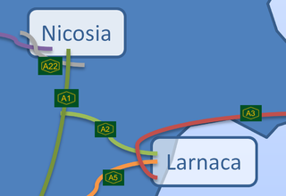
The A2 motorway in Cyprus is a road which branches off the A1 at Pera Chorio-Nisou and connects to the A3. It is referred to locally as the Nicosia - Larnaca motorway. It is also called "the tube" because it is mostly straight with a very limited number of exits. Two of its 6 junctions are limited access to facilitate access to Athienou.

Since the arrival of the first motor cars on the island in 1907, Cyprus has developed a modern road network. According to 2002 statistics, the road network in the Republic of Cyprus-administered areas of Cyprus consists of about 7,206 km of paved and 4,387 km of unpaved roads. Although the first motorway in Cyprus, A1, was completed as recently as October 1985, the country already has the most motorway km per capita among all European Union members. There are no toll paying roads in Cyprus to date.
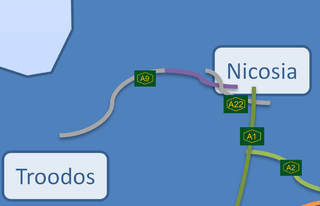
A9 is a highway under construction which is planned to connect Nicosia, the capital of Cyprus, with the Troödos Mountains. Currently this highway is completed until the small village of Dhenia. The project has stopped until the safety of planners will be established. Although, approach towards Troödos from Astromeritis is under planning, with Evrychou, a small village near Kakopetria to be the temporary ending junction.
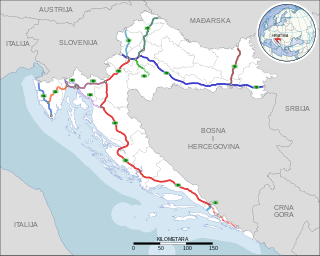
Highways in Croatia are the main transport network in Croatia. The Croatian classification includes several classes of highways:

Motorways in Serbia are called auto-put, a name which simply means car-road. Roads that are motorways are categorized as state roads of IA category and are marked with one or two digit numbers. Motorways in Serbia have three lanes in each direction, signs are white-on-green, and the normal speed limit is 130 km/h (81 mph). They are maintained and operated by the national road operator company JP "Putevi Srbije".
The Timișoara–Moravița Motorway is a proposed motorway in the southwestern part of Romania, labelled as A9. It will connect the city of Timișoara to the border with Serbia. Feasibility studies for the whole motorway are currently ongoing. It is planned to be 72.93 km long.

