
Transportation in Botswana is provided by an extensive network of railways, highways, ferry services and air routes that criss-cross the country. The transport sector in Botswana played an important role in economic growth following its independence in 1966. The country discovered natural resources which allowed it to finance the development of infrastructure, and policy ensured that the transport sector grew at an affordable pace commensurate with demands for services.
This article deals with the system of transport in Namibia, both public and private.

Gobabis is a town in eastern Namibia. It is the regional capital of the Omaheke Region, and the district capital of the Gobabis electoral constituency. Gobabis is situated 200 km (120 mi) down the B6 motorway from Windhoek to Botswana. The town is 113 km (70 mi) from the Buitepos border post with Botswana, and serves as an important link to South Africa on the tarred Trans-Kalahari Highway. Gobabis is in the heart of the cattle farming area. In fact Gobabis is so proud of its cattle farming that a statue of a large Brahman bull with the inscription "Cattle Country" greets visitors to the town. Gobabis also has its own local airport.

The Walvis Bay-Ndola-Lubumbashi Development Road, formerly known as the Trans-Caprivi Corridor and until 2004 the Trans-Caprivi Highway, begins in Walvis Bay. It runs through Rundu in northeastern Namibia and along the Caprivi Strip to Katima Mulilo on the Zambezi River, which forms the border between Namibia and Zambia. The Katima Mulilo Bridge spans the river to the Zambian town of Sesheke. From there, the road continues as the M10 Road to Livingstone, where it connects to the main north–south highway to Lusaka and extends to the Copperbelt.

Kanye is a village in southern Botswana, located 83 kilometres (52 mi) south-west of the capital, Gaborone. It is the administrative centre of the Southern District, and had a population of 48,028 as of the 2022 Population and Housing Census. This is an increase compared to the 45,196 of the 2011 census, making it the ninth-largest village in the country. Kanye is the traditional capital of the Ngwaketse tribe, who first settled in the area in the 1790s. The village is the longest continuously-occupied tribal capital in the country.

The N4 is a national route in South Africa that runs from Skilpadshek on the Botswana border, past Rustenburg, Pretoria, eMalahleni and Mbombela, to Komatipoort on the Mozambique border. The entire route is a toll road.
The Trans-Kalahari Corridor is a paved highway corridor that provides a direct route from the port of Walvis Bay and Windhoek in central Namibia, through Botswana, to Pretoria in Gauteng province in South Africa. It initially cost approximately 850 million Namibian dollars and was officially opened in 1998.

The T1 or Lusaka–Livingstone Road is the main highway of the Southern Province of Zambia. It begins 55 kilometres south of the city of Lusaka and heads south-west to the principal tourist destination, Victoria Falls in Livingstone, via Mazabuka, Monze, Choma and Kalomo, measuring approximately 430 kilometres (267 mi). The entire route is part of Trans-African Highway network number 4 or Cairo-Cape Town Highway between Cairo and Cape Town.
Charles Hill is a village in Ghanzi District of Botswana. It is located close to the Namibian border. Charles Hill is the second-largest village in Ghanzi District, with a population of 3,591 in 2011 census.
List of Railway stations in Botswana include:

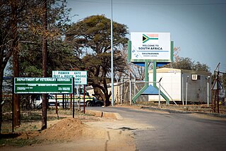
Buitepos is a small settlement in the Omaheke Region in eastern Namibia. It is situated on the national road B6 which is part of the Trans-Kalahari Highway, and a border post between Namibia and Botswana. The proposed Trans-Kalahari Railway may pass through this place, too.

The N11 is a national route in South Africa which runs from the Botswana border at Groblersbrug, through Mokopane, Middelburg, Ermelo and Newcastle to end at the N3 just after Ladysmith.
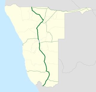
The B1 is a national highway of Namibia, and is the country's longest and most significant road, running the length of the country from south to north. It connects Noordoewer in the south on the South African border with Oshikango in the north on the Angolan border via Namibia's capital city Windhoek.
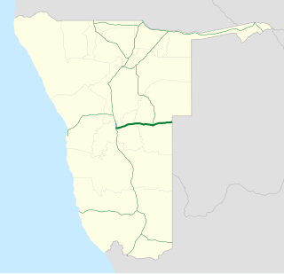
B6 is a national highway of eastern-central Namibia. It is 318 kilometres (198 mi) long and connects the capital Windhoek with the Buitepos border crossing to Botswana. Gobabis, the capital of Omaheke Region, lies on the B6, as do the villages of Seeis, Omitara and Witvlei. Hosea Kutako International Airport is also located on the B6, east of Windhoek.

The N18 is a national route in South Africa which runs from Warrenton through Vryburg and Mahikeng to Ramatlabama on the border with Botswana.

The rail service in Namibia is provided by TransNamib. The Namibian rail network consists of 2,687 km of tracks (2017).
Skilpadshek is a border checkpoint on the South African border with Botswana, located 52 kilometres (32 mi) north-west of Zeerust in North West province. The corresponding checkpoint on the Botswana side of the border is called Pioneer Gate. The Trans-Kalahari Corridor passes through Skilpadshek, and it is the western end of the N4 road, which continues in Botswana as the A2.

Mudumu is a National Park in Caprivi Region of north-eastern Namibia. Established in 1990, the park covers an area of 737 square kilometres (285 sq mi). The Kwando River forms the western border with Botswana. Various communal area conservancies and community forests surround Mudumu National Park.

The border between Botswana and South Africa is 1,969 kilometres (1,223 mi) long. More than 90% of the border follows rivers, including the Nossob, Molopo, Marico and Limpopo.
The A3 highway in Botswana is an 816-kilometre-long (507 mi) road that runs from Francistown through Nata, Gweta and Maun to end at a junction with the A2 road just after Ghanzi.
