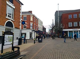
North West Leicestershire is a local government district in Leicestershire, England. The towns in the district include of Ashby-de-la-Zouch, Castle Donington, Coalville and Ibstock. Notable villages in the district include Donington le Heath, Ellistown, Hugglescote, Kegworth, Measham, Shackerstone, Thringstone and Whitwick.

Hinckley and Bosworth is a local government district with borough status in Leicestershire, England. The council is based in Hinckley, the largest town. The borough also includes the town of Earl Shilton and numerous villages and surrounding rural areas. The Bosworth in the borough's name refers to the small market town of Market Bosworth, near which the Battle of Bosworth Field was fought in 1485.

Coalville is a town in the district of North West Leicestershire, Leicestershire in the East Midlands of England. In 2011, it had a population of 34,575. It lies on the A511 between Leicester and Burton upon Trent, close to junction 22 of the M1 motorway where the A511 meets the A50 between Ashby-de-la-Zouch and Leicester. It borders the upland area of Charnwood Forest to the east of the town.

Hinckley and Bosworth is a constituency represented in the House of Commons of the UK Parliament since 2019 by Luke Evans, a Conservative.

Wolvey is a village and parish in Warwickshire, England. According to the 2011 census it had a population of 1,942, which increased to 2,121 at the 2021 census.

Ibstock is a former coal mining village and civil parish in North West Leicestershire, England. The population of the civil parish was 5,760 at the 2001 census increasing to 6,201 at the 2011 census and 7,615 at the 2021 census.

Barwell Football Club is a football club based in Barwell, near Hinckley in Leicestershire, England. They are currently members of the Southern League Premier Division Central and play at Kirkby Road.

Ellistown Football Club is a football club based in the village of Ellistown, near Coalville in Leicestershire, England. They are currently members of the Leicestershire Senior League Premier Division and play at Terrace Road.

Ibstock United Football Club was a football club based in the village of Ibstock, near Coalville in Leicestershire, England. They played at the Welfare Ground.
Ellistown is a village about 2 miles (3 km) south of Coalville in North West Leicestershire, England. It is named after Colonel Joseph Joel Ellis who died in 1885. The population from the 2011 census was included in the civil parish of Ellistown and Battleflat.
The LE postcode area, also known as the Leicester postcode area, is a group of 21 postcode districts in central England, within 12 post towns. These cover most of Leicestershire and most of Rutland, plus small parts of south Nottinghamshire and north Northamptonshire, and very small parts of Derbyshire and Warwickshire.

The River Sence is a river which flows in Leicestershire, England. The tributaries of the Sence, including the Saint and Tweed, fan out over much of western Leicestershire from Charnwood Forest and Coalville in the north-east to Hinckley and almost to Watling Street in the south and south-west. Its watershed almost coincides with Hinckley and Bosworth Borough of Leicestershire, which was formed in 1974 by amalgamation of Market Bosworth Rural District and Hinckley Urban District. It flows into the Anker, which in turn flows into the River Tame. It is part of the wider River Trent catchment, which covers much of central England. In 1881, Sebastian Evans wrote that the usual names for this river were Shenton Brook and Sibson Brook.

The Ashby and Nuneaton Joint Railway was a pre-grouping railway company in the English Midlands, built to serve the Leicestershire coalfield. Both the Midland Railway and the London and North Western Railway (LNWR) wished to build a line on similar alignments, and they agreed to build jointly. Construction began in 1869 and the railway was opened in 1873. It linked Moira and Coalville with Nuneaton. Mineral traffic was busy, and the line formed a useful link for through goods trains. Some long distance passenger operation took place over the line, but it was never successful in carrying passengers.

Hugglescote is a village on the River Sence in North West Leicestershire, England. The village is about 1 mile (1.6 km) south of the centre of Coalville, and its built-up area is now contiguous with the town.

Donington le Heath is a village on the River Sence just over 1 mile (1.6 km) south of the centre of Coalville in North West Leicestershire. Donington is contiguous with the village of Hugglescote immediately to the east. The population of the village is included in the civil parish of Hugglescote and Donington le Heath.
National Cycle Route 63 is a route of the United Kingdom National Cycle Network, running from Burton on Trent to Wisbech.

Kelham Bridge is a 8.1 hectares nature reserve north of Ibstock in Leicestershire. It is owned and managed by the Leicestershire and Rutland Wildlife Trust.


