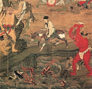
The Sanzu-no-Kawa is a mythological river in Japanese Buddhist tradition similar to the Chinese concept of Huang Quan, Indian concept of the Vaitarani and Greek concept of the Styx.
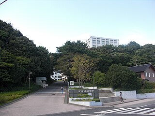
Ryutsu Keizai University is a Japanese private university in Ryūgasaki, Ibaraki. It was founded in 1965. The school has secondary campuses in Matsudo, Chiba and also in Kashiwa, Chiba.

Kashima Soccer Stadium is a football stadium in the city of Kashima, in Ibaraki Prefecture, Japan. It is the home stadium of the Kashima Antlers, a team in the J1 League. The stadium has a capacity of 37,638.

Ariake Coliseum is an indoor sporting arena in Ariake Tennis Park located in Ariake, Kōtō, Tokyo, Japan. It has a capacity of 10,000 and is one of the few professional tennis venues which has a retractable roof.

Kohband District is situated in the northwestern part of Kapisa Province, Afghanistan. It borders Kohistan District to the west, Parvan Province to the north, Nijrab District to the east and Mahmud Raqi District to the south. The population is 26,133 (2019). The district center is Hajjikheyl located in the western part of the district. The people mostly speak Pashayi language.
Korama was a town of ancient Cappadocia, inhabited in Byzantine times.
Eulepa (Εύλεπα) was an ancient Greek town in Cappadocia, inhabited in Hellenistic, Roman and Byzantine times.
El Ksour is a town and commune in the Kef Governorate, Tunisia. As of 2004 it had a population of 5,357. It is located 7.2 kilometres (4.5 mi) to the southeast of Dahmani. The Ancient Roman site Vicus Maracitanus is located to the south. The town contains some fine Berber architecture.
Kalâat Khasba is a town and commune in the Kef Governorate, Tunisia. As of 2014 it had a population of 2,558, compared to 2,871 in 2004. Kalâat Khasba is the chief town of Kalâat Khasba Delegation, which had a population of 7,353 people in 2004.
Menzel Salem is a town and commune in the Kef Governorate, Tunisia. As of 2004 it had a population of 2,211.
Tajerouine is a town and commune in the Kef Governorate, Tunisia. As of 2014 it had a population of 19,362.
Alge Sachi is one of the woredas in the Oromia Region of Ethiopia. It used to be called Supena Sodo woreda. The major town is Alge.
Al-Qubeir is a settlement in the Hama Governorate of Syria, near the larger village of Maarzaf. Al-Qubeir is described as a Sunni farming enclave surrounded by Alawite villages in the central province of Hama.
Bgheidid is a Syrian village located in Al-Saan Subdistrict in Salamiyah District, Hama. According to the Syria Central Bureau of Statistics (CBS), Bgheidid had a population of 50 in the 2004 census.
Pargais was a settlement and station (mutatio) of ancient Cilicia, on the road between Adana and Tarsus, inhabited during Byzantine times.
Moumoustra was a town of ancient Cilicia, inhabited during Byzantine times.
Skandos was a town of ancient Cappadocia, inhabited in Byzantine times.
Cromen was a town in the west of ancient Pontus, inhabited in Roman and Byzantine times. According to the Tabula Peutingeriana it was 11 M.P. from Amasia.
Sibora, also possibly called Foroba, was a town of ancient Pontus, inhabited in Roman and Byzantine times.
Euaissa was a town of ancient Cappadocia, inhabited in Byzantine times.


