Related Research Articles
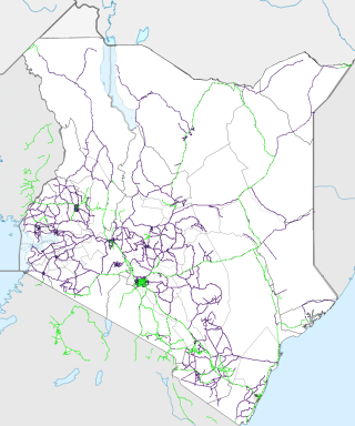
Transport in Kenya refers to the transportation structure in Kenya. The country has an extensive network of paved and unpaved roads.

Mombasa is a coastal city in southeastern Kenya along the Indian Ocean. It was the first capital of British East Africa, before Nairobi was elevated to capital status in 1907. It now serves as the capital of Mombasa County. The town is known as "the white and blue city" in Kenya. It is the country's oldest and second-largest city after Nairobi, with a population of about 1,208,333 people according to the 2019 census.

Bundesautobahn 7 is the longest German Autobahn and the longest national motorway in Europe at 963 km. It bisects the country almost evenly between east and west. In the north, it starts at the border with Denmark as an extension of the Danish part of E45. In the south, the autobahn ends at the Austrian border. This final gap was closed in September 2009.

The Adriatic Highway is a road that stretches along the eastern coast of the Adriatic Sea and is part of the European route E65. The road passes through Croatia, with smaller stretches through Bosnia and Herzegovina and Montenegro and ends at the Montenegro-Albania border. It is an undivided two-lane road for almost its entire length, with the exception of a short stretch through Zadar and a 24 kilometres (15 mi) dual-carriageway section from Plano (Trogir) to the southeast suburbs of Split. It was planned in the 1930s and built in the 50s and 60s. The dual carriageway is planned to be extended further southeast to Omiš. Completion of the Adriatic Ionian motorway is proposed in order to replace Adriatic Highway as a high-performance road transport route along the Adriatic coast.

Kilindini Harbour is a large, natural deep-water inlet extending inland from Mombasa, Kenya. It is 25–30 fathoms (46–55 m) at its deepest center, although the controlling depth is the outer channel in the port approaches with a dredged depth of 17.5 m (57 ft). It serves as the harbour for Mombasa, with a hinterland extending to Uganda. Kilindini Harbour is the main part of the Port of Mombasa, the only international seaport in Kenya and the biggest port in east Africa. It is managed by the Kenya Ports Authority (KPA). Apart from cargo handling, Mombasa is frequented by cruise ships.

The A7 motorway is a 42.4-kilometre-long (26.3 mi) motorway in Croatia. It connects the nation's largest port in Rijeka, to the Croatian motorway network, as well as to the Rupa and Pasjak border crossings to Slovenia. The motorway forms part of a longitudinal transportation corridor in Croatia, and it is a part of European route E61 Villach–Ljubljana–Trieste–Rijeka. The A7 motorway route south of Orehovica interchange, where it also intersects Pan-European corridor Vb, is a part of European route E65.

The D8 state road is the Croatian section of the Adriatic Highway, running from the Slovenian border at Pasjak via Rijeka, Senj, Zadar, Šibenik, Split, Opuzen, and Dubrovnik to the border with Montenegro at Karasovići. Most of the D8 state road remains single carriageway, though with some dual carriageway stretches. The total length of the road through Croatia is 643.1 kilometres (399.6 mi).
The Mombasa–Garissa Road, also B8 Road (Kenya) is a major highway in Kenya, the largest economy in the East African Community. The road connects the port city of Mombasa to the inland city of Garissa. This road is composed of the Mombasa–Malindi Road and the Malindi–Garissa Road.
Kenya Ports Authority (KPA) is a state corporation with the responsibility to "maintain, operate, improve and regulate all scheduled seaports" on the Indian Ocean coastline of Kenya, including principally Kilindini Harbour at Mombasa. Other KPA ports include Lamu, Malindi, Kilifi, Mtwapa, Kiunga, Shimoni, Funzi and Vanga.

Adriatic–Ionian motorway or Trieste-Kalamata Highway or the Blue Corridor, is a future motorway that will stretch along the entire eastern shore of the Adriatic and Ionian seas, spanning the western coast of the Balkan peninsula from Italy in the north through Slovenia, Croatia, Montenegro, Albania to Greece in the south.
Garsen is a small town located in Tana River County, Kenya. It is on the west bank of the Tana River.
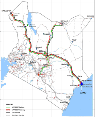
Lamu Port-South Sudan-Ethiopia-Transport (LAPSSET) Corridor project, also known as Lamu corridor is a transport and infrastructure project in Kenya that, when complete, will be the country's second transport corridor. Kenya's other transport corridor is the Northern Corridor, which links Mombasa to Uganda, passing through Nairobi and much of the Northern Rift. Some basic LAPSSET infrastructure has been built. The construction of LAPSSET's main components is currently ongoing with construction of the first berth at Lamu Port completed in October 2019.. Although the project is not formally stalled, its short to medium term success looks increasingly unlikely. Insecurity and political instability in Kenya are mostly to blame for this, as are more commercially viable alternative pipeline options through Tanzania or Ethiopia. The low oil prices since 2015 also affect LAPSSET's commercial prospects.

The Georgian S1 route, is a "road of international importance" with a registered length of 542.7 kilometres (337.2 mi) within the Georgian classification system, which makes it the longest Georgian highway route. It runs from Tbilisi via Mtskheta, Gori, Khashuri, Zestaponi, Kutaisi, Samtredia, Senaki, Zugdidi, Sukhumi and Gagra to the border with Russia near Leselidze at the northwestern tip of the country, covering in practice 537 kilometres (334 mi). After crossing the Georgia–Russia border in breakaway Abkhazia, the highway continues to Sochi and Krasnodar as A147. It is part of European E60, E97 and E117 routes and Asian Highways AH5, AH81 and AH82, and connects with six other S-routes.

Controlled-access highways in Romania are dual carriageways, grade separated with controlled-access, designed for high speeds. There are two types of highways, motorways and expressways, with the main difference being that motorways have emergency lanes and slightly wider lanes. The maximum allowed speed limit for motorways is 130 km/h (81 mph), while for expressways the limit is 120 km/h (75 mph). There are no toll roads, but a road vignette is required.
The Malindi–Bagamoyo Highway, also Coastline Transnational Highway, is a road in Kenya and Tanzania, connecting the cities of Malindi and Mombasa in Kenya to Tanga and Bagamoyo in Tanzania.
The A6 road is a road in Kenya spanning 113 kilometers which serves as an east–west artery in Kenya, connecting the Tanzanian border at Taveta to the bustling A8 route at Voi. The trunk road provides a crucial link between the two points, facilitating the flow of traffic and commerce across the region.
The A7 road is a road in Kenya that spans 923 kilometers. It connects the Ugandan border to the port city of Mombasa, passing through Eldoret and Nairobi. The road is one of the main transportation routes in Kenya, providing an east–west connection. It also serves as a route for international traffic to and from Uganda.
The A12 road is a road in Kenya spanning a distance of 228 kilometers. It traverses the western region of the country, forming a crucial east–west route. The A12 originates at the Ugandan border in Busia and extends westward, passing through the city of Kisumu before terminating at Mau Summit. This transportation artery connects key urban centers and facilitates movement across the region, playing a role in Kenya's infrastructure network.
References
- 1 2 3 4 "Kenya Roads Board" . Retrieved 2024-08-05.
- 1 2 Mandela, Dominic (2020-03-04). "Construction of the 2nd Nyali bridge in Kenya to begin in June". Constructionreview. Retrieved 2024-08-05.
- ↑ Kenya Gazette Supplement No. 4 of 2016
- ↑ Malindikenya. "How Mombasa will change with Nyali 2nd bridge - World bank funds approved, works starting in June". malindikenya.net (in Italian). Retrieved 2024-08-05.
- ↑ Andeso, Albert (2021-08-12). "Work Underway on Phase 2 of Dongo Kundu Bypass". CK. Retrieved 2024-08-05.
- ↑ http://kenyalaw.org/kl/fileadmin/pdfdownloads/Acts/KenyaRoadsAct_No2of2007.pdf