This article may need to be rewritten to comply with Wikipedia's quality standards.(December 2021) |
ABC Highway | |
---|---|
Major junctions | |
From | Grantley Adams International Airport in Christ Church |
To | Cave Hill Campus, University of the West Indies, in Saint Michael |
Location | |
Country | Barbados |
Highway system | |
The ABC Highway is the main urban highway in Barbados. Opened in 1989, it is named after three famous Barbadian politicians: John Michael Geoffrey Manningham ("Tom") Adams, Errol Barrow, and Hugh Gordon Cummins. From the east, the highway stretches from the Grantley Adams International Airport in Christ Church, to the western end at Cave Hill Road and University Drive, Cave Hill Campus, University of the West Indies, in Saint Michael. It roughly encircles the Parish of Saint Michael and the wider metropolitan area of Bridgetown.
The highway consists of two-lane and dual carriageway sections with at-grade intersections, mostly roundabouts. A 2006–2007 expansion project enlarged some areas, and there was some public sentiment voiced in local media about the project's lack of a competitive tender process or studies to justify costs. On July 24, 2006, Rayside Construction and C.O. Williams Construction, two local companies, began the construction and widening of the ABC Highway from the Darcy Scott Roundabout in Warrens, St. Michael to the Garfield Sobers Roundabout in Bartletts, Christ Church. As part of the project, the old streetlights and traffic lights at the junctions of the ABC Highway and Pine East-West Boulevard, Upton Road at BET Hill on Highway R and Highway 6 were removed, and jersey barriers were constructed in the center. Additionally, new HPS streetlights were installed along the highway, and new roundabouts, including the Samuel Jackman Prescod and Darcy Scott Roundabouts in Warrens and the Pine, St. Michael, were constructed. The Greater Warrens Traffic Improvement Project was started from late December 2010 into early January 2011 to mid-December 2014 with construction and widening of Jackson Road on Highway 2 to the newly constructed Jackson Roundabout around the Baobab Tree and Lodge Hill, St. Michael, two Warrens Mini Roundabouts in Warrens, St. Michael and the Welches and Redmans Village Roundabouts in St. Thomas. On 27 April 2008, during its effect, they changed the junctions from a two-way street into a one-way street with the Wildey "Y" Junction of Upton Road on Highway R, the ABC Highway and Highway 6. There was also a footbridge construction at the Pine, St. Michael, from early September to late November 2012. They had also installed two new traffic lights; one at the pedestrian crossing at Mount Friendship, St. Michael, and another at Redman's Village, St. Thomas. The construction of the four-lane highway was finished by 31 August 2009. Also, the same construction with the Greater Warrens Traffic Improvement Project had started with the widening of the Ronald Mapp Highway on Highway 2A from the top of Warrens Hill, St. Michael to the top of Redman's Village, St. Thomas with the installation of jersey barriers and new streetlights along Highway 2A, Jackson Road on Highway 2 and the Warrens South Road with three roundabouts: two mini and a circular roundabout. Highway 2A between the top of Warrens Hill in St. Michael to the top of Redman's Village in St. Thomas via Welches in St. Thomas, was unfinished and incomplete and will soon be finished and completed after the elections of the new BLP Government. Finally, in the parish of St. Michael, from late April 2001 to late October 2003, they constructed from its entrance and exit to Dalkeith Road at the Garrison Savannah along with the junctions of Dalkeith Road and Harts Road; Dalkeith Road, Dalkeith Hill, Beckles Road and Culloden Road; Culloden Road, Pine Road, Bishop's Court Hill and Collymore Rock; Pine Road, with a reconstruction of Nita Barrow Roundabout, Pine Hill, Welches Road and Belmont Road, Government Hill, Welches Main Road and Tweedside Road; the junction of Roebuck Street and Country Road; the junction of Country Road, Passage Road, Whitepark Road and Bank Hall Road; the junction of Passage Road, Westbury Road, Baxters Road and Barbarees Hill; the junction of Westbury Road, Westbury Main Road, Prescod Boulevard and President Kennedy Drive; the junction of Eagle Hall Main Road, Black Rock Road, Barbarees Hill and Tudor Bridge; the junction of Black Rock Road, Black Rock Main Road, Deacons Road and Fairfield Road, some of the traffic lights and streetlights; and the junction of Black Rock Main Road, Brighton Road and Yearwood Road; and also they constructed Baxters Road before they removed all the old utility poles and replaced them with some of the CFL English lampposts.
This section is missing kilometre posts for junctions. |
Parish | Location | km | mi | Destinations | Notes |
---|---|---|---|---|---|
Christ Church | Seawell | 0.0 | 0.0 | Highway 7 (Tom Adams Roundabout) | 13°4′49″N59°29′28″W / 13.08028°N 59.49111°W |
Newton Terrace | 4.4 | 2.7 | Highway T (Henry Forde Roundabout) | 13°4′49″N59°31′50″W / 13.08028°N 59.53056°W | |
Kendal Hill | 7.5 | 4.7 | Kendal Hill Road (Edwy Talma Roundabout) | 13°4′42″N59°33′28″W / 13.07833°N 59.55778°W | |
Graeme Hall | 8.7 | 5.4 | Graeme Hall Road (Errol Barrow Roundabout) | 13°4′38″N59°34′6″W / 13.07722°N 59.56833°W | |
Saint Michael | Wildey | 10.3 | 6.4 | Highway 6 (Sir Garfield Sobers Roundabout) | 13°5′13″N59°34′37″W / 13.08694°N 59.57694°W |
10.8– 11.6 | 6.7– 7.2 | Highway 6 / Highway R (Wildey Triangle [1] ) | No access to Highway R from westbound lanes, 13°5′26″N59°34′50″W / 13.09056°N 59.58056°W | ||
12.0 | 7.5 | Samuel Jackman Prescod Polytechnic Roundabout | 13°5′43″N59°34′48″W / 13.09528°N 59.58000°W | ||
Haggatt Hall | 13.1 | 8.1 | Highway 5 (J.T.C. Ramsey Roundabout) | 13°6′18″N59°34′48″W / 13.10500°N 59.58000°W | |
Rouen | Highway 4 (Norman A. Niles Roundabout) | 13°6′49″N59°35′0″W / 13.11361°N 59.58333°W | |||
Friendship/Belle | Highway 3 (Clyde Walcott Roundabout) | 13°7′36″N59°35′43″W / 13.12667°N 59.59528°W | |||
Warrens | Highway 2 (Everton Weekes Roundabout) | 13°8′30″N59°36′23″W / 13.14167°N 59.60639°W | |||
Ronald Mapp Highway (D'Arcy Scott Roundabout) | 13°8′34″N59°36′36″W / 13.14278°N 59.61000°W | ||||
Cave Hill, Saint Michael | University Drive, Cave Hill Road | Road continues as University Drive to the Frank Worrel Roundabout. 13°7′54″N59°38′0″W / 13.13167°N 59.63333°W | |||
1.000 mi = 1.609 km; 1.000 km = 0.621 mi |
The ABC Highway provides relatively easy of access to the Deep Water Harbour in Bridgetown. At the official western terminus, the road becomes University Drive (at Cave Hill). The route proceeds to the Frank Worrel roundabout, where it has a junction with Highway 1 and the MacDonald 'Mighty Grynner' Blennman (formerly "Spring Garden") Highway. Direct access to the harbor is available via the M.G Highway from the Frank Worrel roundabout. At the end of M.G. Highway, direct access to the port is accessed by turning right onto President Kennedy Drive.
Bridgetown is the capital and largest city of Barbados. Formerly The Town of Saint Michael, the Greater Bridgetown area is located within the parish of Saint Michael. Bridgetown is sometimes locally referred to as "The City", but the most common reference is simply "Town". As of 2014, its metropolitan population stands at roughly 110,000.
The M1 motorway connects London to Leeds, where it joins the A1(M) near Aberford, to connect to Newcastle. It was the first inter-urban motorway to be completed in the UK; the first motorway in the country was the Preston Bypass, which later became part of the M6.
The M2 is a 26-mile-long (42 km) long motorway in Kent, England, and was built to bypass a section of the A2 road in Kent, which goes through the Medway Towns, Sittingbourne, and Faversham. It provides an alternative route to the Port of Dover, which supplements the M20 motorway located further to the south. The terminal junctions of the M2 intersect with the A2, which come together to form a 62-mile-long (100 km) long trunk road from London to Dover.
The A68 is a major road in the United Kingdom, running from Darlington in England to the A720 in Edinburgh, the capital of Scotland. It crosses the Anglo-Scottish border at Carter Bar and is the only road to do so for some distance either way; the next major crossings are the A697 from Coldstream to Cornhill-on-Tweed in the east, and the A7 near Canonbie to the west.
The parish of St. Michael is one of eleven parishes of Barbados. It has a land area of 39 km2 (15 sq mi) and is found at the southwest portion of the island. Saint Michael has survived by name as one of the original six parishes created in 1629 by Governor Sir William Tufton.
The A350 is a north–south primary route in southern England, that runs from the M4 motorway in Wiltshire to Poole in Dorset.
The A500 is a major primary A road in Staffordshire and Cheshire, England. It is dual carriageway for most of its length and connects Nantwich, junctions 16 and 15 of the M6 motorway with the city of Stoke-on-Trent. It is 19 miles (31 km) long.
The parish of Christ Church is one of eleven historic political divisions of Barbados. It has a land area of 57 km2 (22 sq mi) and is found at the southern end of the island. Christ Church has survived by name as one of the original six parishes created in 1629 by Governor Sir William Tufton.
The parish of Saint James is an area located in the western central part of the country of Barbados. Increasingly St. James is becoming known as the playground of the rich and famous, and as a haven for sun-starved tourists with its up-market hotel resorts.
The landlocked parish of Saint Thomas is found in the centre of Barbados. It is one of only two landlocked parishes in the island, the other being Saint George to the south.
The A4540 is a ring road in Birmingham, England, also known as the Middle Ring Road, or the Middleway. It runs around the centre of the city at a distance of approximately 1 mile (1.6 km). The ring road was planned and designed by Herbert Manzoni. It is now simply known as the Ring Road due to the removal of the old Inner Ring Road.
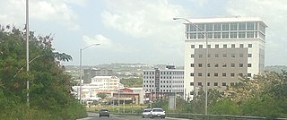
The City of Warrens, located in the parish of Saint Thomas, is one of the fastest developing areas in the country of Barbados. In the span of a few years beginning around the year 2000, the Warrens, Saint Thomas area has become synonymous with new money flowing into the country and for the development in the form of newly constructed tall buildings.
The Wildey area of the Parish of Saint Michael located roughly 4 km east of Bridgetown, it lies on the border with the Parish of Christ Church. Normally a very busy area with the ABC Highway, Wildey is one of the main convergence points for vehicles travelling either towards the capital-city Bridgetown or towards points in northern Barbados. In recent years the area was reconfigured for traffic mitigation, the tri-directional split or fork in the highway formerly known as the "Wildey Y" was changed to only allow southbound traffic to turn left or right on to Wildey Road only. Northbound traffic must now travel on Wildey Road to Highway R road which brings traffic back to BET hill.
The A380 is a road in South West England, connecting the Torbay area to the Devon Expressway, and hence to the rest of Great Britain's main road network.
The A585 is a primary road in England which runs from Kirkham to Fleetwood in Lancashire.
The A616 is a road that links Newark-on-Trent, Nottinghamshire, to the M1 motorway at Junction 30, then reappears at Junction 35A and goes on to Huddersfield, West Yorkshire.
The A6003 links Kettering and Corby in Northamptonshire, with Oakham in Rutland, via Leicestershire. The road forms the principal link between Rutland and Northamptonshire.
The City of Bridgetown constituency is one of eleven (11) electoral districts in the Parish of St. Michael, and one thirty (30) nationally in Barbados. The Constituency covers a portion of the capital city Bridgetown. The district formed in 1843 is the first electoral district formed after the original eleven in the country. The first representative for the constituency was the national hero the Right Excellent Samuel Jackman Prescod. The member of parliament since 2022 is Corey Lane from the Barbados Labour Party. Before then it was held by Lt.Col. Jeffrey Bostic (Ret.) from 2013. The seat is usually won by a slim margin.